Exprodat Increases Oil & Gas Workflow Integration with Updated Data Assistant
Exprodat, the oil and gas ArcGIS platform specialist, Esri Gold Partner and Getech group company, has released the latest version of its popular Data Assistant software, which simplfies and speeds up the process of importing and exporting common exploration data, to and from Esri’s ArcGIS platform. Data Assistant v222 is now compatible with ArcGIS Desktop 10.4 and 10.4.1 which means those people working with the latest Esri software versions will be able to benefit from easily importing cruci...
UTGIS Launches Mobile Electrical Safety Testing for IEEE 1695™ Contact Voltage Programs
PORT ST. LUCIE, Fla., — Utility Testing and Geographic Information Systems (UTGIS) announced today the launch of their Mobile Electrical Safety Testing (MEST) program. The MEST program is designed for utilities and municipalities interested in identifying and resolving contact voltages on their electrical infrastructure assets. "Contact voltage" defined by the new IEEE 1695 Guide to Understanding, Diagnosing and Mitigating Stray and Contact Voltage, is any fault voltage potential between two...
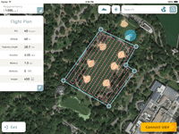
Datumate Unveils DatuFly, A Professional Imagery App for Drones
YOQNEAM, Israel, September 6, 2016 - Datumate, a market leader of automated "Field-to-Plan" solutions that save costly field and office time, is pleased to announce a new tablet app for effortless drone flight planning and automated, high resolution photo-shooting. DatuFly™ app saves up to 80% of field surveying time and eliminates follow-up site visits. "DatuFly™ automates the entire field surveying process, while keeping field work simple and safe," says Tal Meirzon, Datumate CEO. "Ease of...
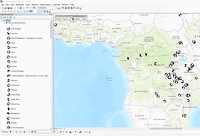
RAND and Lawrence Livermore National Lab Combine High Performance Computing and Public Policy Analysis for Demonstration of Water Resource Management
Researchers from the RAND Corporation and the Lawrence Livermore National Laboratory have joined forces to combine high-performance computing with innovative public policy analysis to improve planning for particularly complex issues such as water resource management. Building on previous work conducted by RAND on the Colorado River Basin in 2012, RAND and the High Performance Computing Innovation Center at Lawrence Livermore National Lab hosted a joint workshop to employ high-performance...

New SphereVision 360 Imaging Software Integrates iSTAR Measurement Module
Shepperton Studios, London – Arithmetica has released a new version of the SphereVision 360 degree imaging software with support for NCTech’s industrial grade iSTAR panoramic camera. SphereVision Project Builder now includes brand new functionality, allowing iSTAR users to capture measurements directly from within a spherical image. With applications including forensic evidence collection, as built surveying, asset management and construction, for example, this new functionality is designed for...

Urbano 9.0.28.0 Released!
The main focus of this release was achieving full compatibility on all AutoCAD 2017 product versions. In particular, Urbano 9.0.28.0 provides: - support for Autodesk AutoCAD 2017 products - improved pipe intersection & clash analysis tool - improved pipe topology checking tool - new system recovery tool - new element selections for protection pipes and additional network data Being the first major update since December, Urbano 9.0.28.0 includes many bug fixes and feature enhancements,...
Innovyze Releases SWMMLive and ICMLive Generation V7.0, Powering Real-Time Stormwater, Wastewater and Watershed Modeling
Broomfield, Colorado, USA — leading global innovator of business analytics software and technologies for smart wet infrastructure, today announced the worldwide release of the V7.0 Generation of its SWMMLive and ICMLive for real-time operational forecasting, modeling and management of urban drainage systems. The latest release sets the scene for the next quantum leaps in smart water modeling, giving wastewater utilities an unsurpassed tool for operating and managing their collection systems, ide...
Drone Mapping Software Provider Pix4D Elevates Agriculture Software to Desktop & Cloud Solution, Launches Flexible Monthly Rental Option at InfoAg
Today Pix4D announces its first hybrid processing solution: this week, users of Sequoia with a license of Pix4Dmapper Ag will be able to process both locally in Pix4Dmapper Ag and on the Pix4Dcloud. Together with this announcement, Pix4D also introduces very flexible monthly (149 USD) and yearly (1490 USD) plans for its Pix4Dmapper Ag solutions. This new strategy comes from seeing the need in the agriculture industry for more flexible processing options to facilitate competitive operations. W...

Successful Commissioning of Heap Profile and Volume Measurement System at ADANI
Further two reclaimers have been equipped with 3D laser measurement system at ADANI ports in Mundra, India. The system also includes a specific manager application, where a segmentation of multiple piles is shown as well as volume and weight information. A high reusability for further projects was concluded. The system for heap volume measurement determines information like e.g. volume, 3D profile, peaks by using 3D laser scanners from the LASE 3000D-S-13x Series, which are installed on top o...

AirGon LLC Revolutionizes Drone Data Extraction
Huntsville, AL – AirGon LLC, a wholly owned subsidiary of GeoCue Group, Inc., announces the launch of Topolyst™, an advanced desktop application designed to make easy work of extracting information and derived products from point cloud and/or LIDAR data collected by drones over construction and mining sites. The return on investment of Topolyst is almost immediate - site data collections that used to take days are now completed in hours with Topolyst’s strong complement of automated tools. Ap...
Stormwater Interview with Robert Page, P.E., Vice President, HNTB

TriMet’s Banfield Type 1 Substation Replacement Project

February Issue 2026
