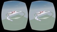
Autodesk LIVE now supports HTC Vive or Oculus Rift
Autodesk brought “on demand” interactivity to the architecture, engineering and construction (AEC) industries when we introduced Autodesk LIVE for Autodesk Revit in July. LIVE is the game-changing, cloud-based service that transforms your Revit model into an interactive experience, in just one click. Rather than just seeing your model, LIVE lets you experience it. If one click automates complex Building Information Modeling (BIM) data processing, what could Autodesk achieve with a second...
senseFly to Unveil New RTK/PPK-Ready, Large Coverage Mapping Drone at INTERGEO 2016
Cheseaux-Lausanne, Switzerland – senseFly, the world’s first choice producer of professional mapping drones, will introduce its next-generation fixed-wing system for survey-grade photogrammetric mapping, the eBee Plus, at INTERGEO 2016 on Oct. 11 in Hamburg, Germany. “The eBee Plus system is the ultimate tool for geospatial organisations that demand photogrammetric-quality mapping,” said senseFly’s CEO, Jean-Christophe Zufferey. “With its unique upgradeable RTK/PPK functionality and fli...

DTS and SmarterBetterCities Partnership Extends 3D to Asset Management
San Francisco, Calif. – DTS and SmarterBetterCities are pleased to announce a partnership that brings 3D tools and sharing to asset management. The world is not flat. Why run an asset management system that only allows you to track work management, perform condition assessments and generate projects for a capital improvement plan in the second dimension? This partnership will make the interaction with VUEWorks both richer and more intuitive. Using VUEWorks and CloudCities together brings many...

Contech's UrbanGreen Rainwater Harvesting Tank Receives Uniform Plumbing Code Certification
WEST CHESTER, Ohio, Oct. 3, 2016 - West Chester-based Contech Engineered Solutions announced today that the UrbanGreen Steel Reinforced Polyethylene Rainwater Harvesting Tank has been certified to be in compliance with the Uniform Plumbing Code (UPC®) by The International Association of Plumbing and Mechanical Officials (IAPMO) Research and Testing. Designated as an American National Standard, the UPC is a model code developed by the International Association of Plumbing and Mechanical Offici...

SITECO Partners with Pavemetrics Inc., Launching Pave-Scanner, the First Infrastructure and Pavement Inspection System
Bologna, Italy - SITECO Infomatica SRL has completed integration of the Pavemetrics vision system technology product lines onto the SITECO Road-Scanner hardware and software platforms. This partnership has made available the first commercially available true 360 degree infrastructure and pavement surface inspection system. This new Laser Automated Road Analyzer system, called the PAVE-Scanner, is already deployed and in use in the EU. SITECO brings it’s iRAP Accreditation Specification fo...
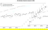
Orbital Insight Measures China Oil Supply With Satellite Imagery Analysis
Orbital Insight, a US-based geospatial analytics and software company, today announced the general availability of China Oil, the latest addition to its global oil supply monitoring tools. Using a proprietary combination of machine learning and computer vision, Orbital Insight can analyze satellite imagery to accurately estimate how much oil is being stored in China at any given time. This product joins other offerings from the company, which include retail parking lot car counts, freshwater res...
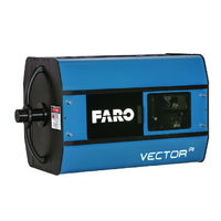
FARO Disrupts In-Process Guided Assembly and Verification with the Introduction of a New Class of LIDAR with High Speed Imaging (HSI) Technology
LAKE MARY, Fla. - FARO® (NASDAQ: FARO), the world's most trusted source for 3D measurement and imaging solutions for factory metrology, product design, construction BIM/CIM, public safety forensics and 3D solutions and services applications, announces the launch of the FARO VectorRI Imaging Laser Radar, an ultra-high speed, large-volume, non-contact 3D measurement solution with high-resolution 3D imaging and projection guidance for manual and automated manufacturing processes. “This product i...
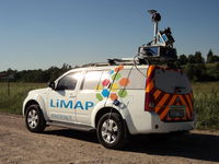
Lithuanian Survey Experts Takes Delivery of SITECO Road-Scanner
Bologna, Italy - SITECO Infomatica SRL has completed the delivery and commissioning of a Road-Scanner-4 to LiMAP, UAB of Vilnius, Lithuania. This latest delivery of the high performance Road-Scanner-4 is the first such configuration in Lithuania and the second of a SITECO mobile mapper to the Baltic region. The system is configured with two Zoller & Froelich (Z+F) 9012 Profiler laser scanners, a Point Grey Ladybug 5 spherical camera and an XBLUE Atlans IMU and inertial navigation system....
Exprodat Software Revolutionises Unconventionals Planning
Exprodat, the oil and gas ArcGIS platform specialist, Esri Gold Partner and Getech group company, has released a new version of its Unconventionals Analyst software. The company developed the Unconventionals Analyst extension to ArcGIS Desktop to help oil and gas companies simplify and speed up the processes of optimising unconventional well patterns and managing reserves. Version 222 of Unconventional Analyst includes a host of new features all of which have been designed to give the user...
OGC Publishes Testbed 12 Aviation Thread Engineering Reports
Members of the Open Geospatial Consortium (OGC®) recently approved the release of 7 draft public OGC Engineering Reports, products of the recently completed OGC Interoperability Testbed 12 Aviation Thread. Testbed 12’s Aviation Thread was sponsored by FAA and Eurocontrol, and is the most recent in the OGC's long series of major geospatial interoperability initiatives. The 7 released draft engineering reports focus on Aviation Information Management, specifically: •Semantics - Managing comple...
Stormwater Interview with Robert Page, P.E., Vice President, HNTB

TriMet’s Banfield Type 1 Substation Replacement Project

February Issue 2026
