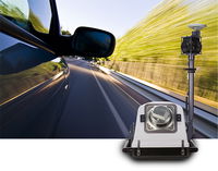
Teledyne Optech Doubles Scanner Speed with Lynx HS-600 Mobile Surveying Solution
Teledyne Optech is happy to announce the release of the Optech Lynx HS-600 mobile lidar scanner. Available in single- and dual-sensor configurations, the HS-600 is a major step forward for collecting uniform lidar data from high-speed platforms. The HS-600 model is an addition to the Lynx product line and complements the industry-leading Optech Lynx SG and SG-S models by providing an incredible 1200 lines/second scanner speed on the dual-sensor version. This, combined with a 1.6-MHz collectio...
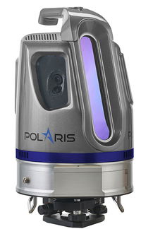
Brand-New Optech Polaris Terrestrial Laser Scanner Launches at INTERGEO 2016
Teledyne Optech is pleased to announce the release of its new Optech Polaris TLS Series of tripod-mounted laser scanners, which bridge the gap between small short-range scanners and heavier long-range scanners. Over three years in development, the Polaris is a sensor designed by surveyors for surveyors, based on Teledyne Optech’s decades of lidar experience. Launching with three distinct models at separate price points and a multitude of options and features, the Polaris promises to bring Tel...
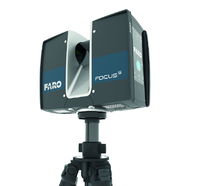
FARO Launches the FocusS Laser Scanner with IP54 Rating and In-Field Compensation for Construction BIM-CIM and Public Safety Forensics Professionals
LAKE MARY, Fla. - FARO® (NASDAQ: FARO), the world's most trusted source for 3D measurement and imaging solutions for factory metrology, product design, construction BIM/CIM, public safety forensics and 3D solutions and services applications, announces the release of the all-new FARO FocusS Laser Scanner. The FocusS is the newest member of FARO’s popular Focus Laser Scanner product line and is available in both 150m and 350m ranges. Designed for construction BIM-CIM and public safety forensics...
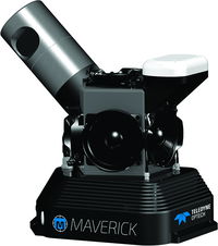
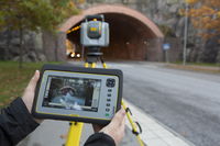
Teledyne Optech Unveils the Ultra-light Maverick for Mobile Asset Mapping
Teledyne Optech is excited to announce the release of its Maverick mobile mapping system. Light enough to be worn on a backpack, the Maverick sets a high bar for size, portability and versatility in mobile asset mapping. Weighing in at less than 9 kg, the Maverick integrates a lidar, a 360° camera, and an INS into an extremely small form factor that is easy to install, while maintaining the data quality that users expect from a Teledyne Optech system. Never has accurate, mobile asset data bee...
Trimble Expands 3D Laser Scanning Portfolio with Addition of New TX6 and Improved TX8
HAMBURG, Germany - Trimble (NASDAQ: TRMB) introduced today its new Trimble® TX6 and improved TX8 high-performance 3D laser scanning solutions. With a fully integrated High Dynamic Range (HDR) camera and Wi-Fi remote control, the high-speed 3D laser scanners provide increased productivity and versatility for users. The TX6 and the TX8 leverage Trimble's patented technology, combining microsecond time-of-flight distance measurement with advanced on-board signal and 3D data processing, designed to...
Sedaru Deploys Smart CIP, Advancing the Connected Utility, Empowering Integrated, Dynamic Asset Management for Water/Wastewater Systems
/ / / / ARCADIA, Calif. - IDModeling, Inc. the leading global provider of smart water software and services, announced today the deployment of Smart CIP™ for integrated, dynamic asset management of water & wastewater systems. Sedaru's Smart CIP technology provides a lightweight, sophisticated, enjoyable-to-use platform for utilities to connect their data, experience, and institutional knowledge to quantify and prioritize capital improvement projects (CIPs) to consistently measure and increa...

TomTom’s HD Map Powers Autonomous Driving
MELBOURNE, Australia - ITS World Congress – TomTom (TOM2) today announces a joint autonomous driving demonstration with Bosch. TomTom provided its HD Map and RoadDNA technology to setup a demonstration on the Australian F1 Grand Prix circuit at Albert Park; these novel products are important components to enable Bosch’s demo vehicle to perform in autonomous driving mode. TomTom HD Map and RoadDNA are two revolutionary, highly accurate digital map based products helping automated vehicles precise...
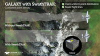
Teledyne Optech Announces New Efficiency Enhancement for ALTM Galaxy Wide-Area Lidar Mapping Sensor
Teledyne Optech is pleased to announce a high-performance scanner update to its innovative line of airborne laser terrain mappers, the Optech Galaxy ALTM™. The Galaxy’s scan efficiency has been engineered to deliver an additional 30% boost to its class-leading area coverage rates. When coupled with its innovative SwathTRAK™ and PulseTRAK™ technologies, collection efficiencies exceeding 70% are possible, relative to the traditional fixed-FOV dual-beam sensors currently on the market. According...
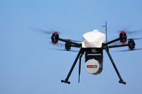
InterGEO2016: AltiGator and YellowScan Unveil a 5.6kg Survey-Grade LiDAR UAV all Integrated System, Ideal for Centimetric Urban Surveys
AltiGator and YellowScan are pleased to announce an ultra-light weight LiDAR UAV combo allowing for the first time centimetric UAV surveys in urban areas, in accordance with most regulations. The YellowScan Surveyor ultra-light stand-alone LiDAR system is embedded on the OnyxStar® XENA multirotor UAV, which is the last generation professional drone designed by Altigator. Compact, light, powerful and foldable, Xena is the result of the analysis of users' operational needs and months of Rese...
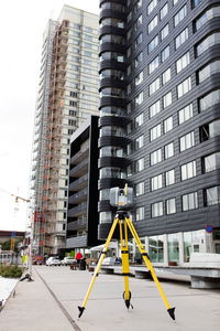
Trimble Unveils SX10 Scanning Total Station for Surveying, Engineering and Geospatial Professionals
SUNNYVALE, Calif., - Trimble (NASDAQ: TRMB) unveiled today a next-generation survey instrument—the Trimble® SX10 Scanning Total Station. It merges high-speed 3D scanning, enhanced Trimble VISION™ imaging technology and high-accuracy total station measurements into familiar field and office workflows for surveyors. The innovative solution provides surveyors and geospatial professionals with the capabilities and versatility to handle projects from traditional surveys to complex 3D modeling. Th...
Stormwater Interview with Robert Page, P.E., Vice President, HNTB

TriMet’s Banfield Type 1 Substation Replacement Project

February Issue 2026
