Vexcel Intelligence Gives AI Eyes, Making the World Searchable for the First Time
First-of-its-kind platform brings vision to AI through high-resolution aerial imagery, making the physical world searchable for the first time.DENVER - AI can summarize the internet. Now it can understand the Earth. Vexcel today launched Vexcel Intelligence, a breakthrough AI platform trained on continuous high-resolution aerial imagery that allows organizations and AI systems to search and reason against the physical world for the first time."Until now, AI has relied on what's been captured onl...
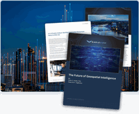
Eagleview White Paper Warns: Geospatial Intelligence Is About to Change Forever
From conversational AI to agent-driven systems, the report says maps are becoming obsolete and decision-making is moving to machine speed.Rochester, NY, Mar 04, 2026 - Eagleview, a leader in aerial imagery and geospatial intelligence, today released a new executive briefing warning that geospatial intelligence (GEOAI) is entering the most consequential transformation in its history. Within the next twenty years, the industry will fundamentally change how organizations see, understand, and act on...
.jpg?width=200)
Grass America Defines Excellence with Dynapro Undermount Slides, Built on Precision and Innovation
14 Years of Unmatched Synchronization and Engineering InnovationKernersville, N.C.: Grass America, Grass America, a trailblazer in functional hardware for the cabinet industry, proudly showcases its established synchronized Dynapro 3D and 2D undermount slides. Representing 14 years of refinement and innovation, these slides epitomize Grass’ dedication to precision engineering and its position as the industry leader in synchronized sliding technology.At the heart of the Dynapro system is its hall...
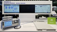
Rohde & Schwarz advances AI-RAN testing using digital twins with NVIDIA
Caption: Prior collaboration with NVIDIA: Testbed for AI/ML-based neural receiver as seen at MWC Barcelona Rohde & Schwarz, in collaboration with NVIDIA, continues to drive AI-RAN innovation for 5G-Advanced and 6G. The latest testbed to be showcased at MWC Barcelona 2026 integrates ray-tracing-based, site-specific channel emulation with the NVIDIA Sionna Research Kit to enable digital twin-based hardware-in-the-loop testing without leaving the lab.Rohde & Schwarz will showcase a new milestone in...
Leica Geosystems and Liebherr expand factory-integrated machine control for Generation 8 crawler and mobile excavators
(LAS VEGAS, USA) Leica Geosystems, part of Hexagon, and Liebherr today announced a major expansion of their long-standing collaboration with the factory integration of Leica Geosystems’ sensor chain across Liebherr’s Generation 8 mobile and crawler excavators as per default. The new solution is available ex-factory, providing contractors with immediate productivity benefits and a clear upgrade path to advanced 3D machine control.The integrated sensor chain from Leica Geosystems will serve as the...

Leica Geosystems expands 3D machine control compatibility options for Caterpillar Next Gen Wheeled Excavators
Leica Geosystems, part of Hexagon, expands 3D machine control compatibility to Caterpillar Next Gen Wheeled Excavators.The Leica MC1 solution boosts accuracy, efficiency, and sustainability across Caterpillar equipment.Available March 2026, the new aftermarket system streamlines installation and enhances performance. HEERBRUGG, SWITZERLAND: Leica Geosystems, part of Hexagon, today announced the expansion of its offerings to deliver advanced aftermarket 3D machine control solutions for Caterpilla...
Advanced Navigation Launches Chimera Land: A Laser Velocity Breakthrough in Uncharted Underground Mining
Global - Advanced Navigation, a global leader in autonomous systems, has announced the launch of Chimera Land. A new class of navigation, this 3D Laser Velocity Sensor (LVS) is specifically designed to solve the primary challenge for underground mining: maintaining precise vehicle positioning in deep, dark, and unmapped environments where GPS cannot reach.In underground mining, knowing exactly where a vehicle is located is mission-critical. Traditional navigation relies on GPS signals, which dis...
AGTEK introduces Reveal Transform: AI‑powered data preparation for faster, smarter takeoff and production tracking
(Livermore, California, 26 February 2026) AGTEK, part of Hexagon, today announced Reveal Transform, a new AI module that simplifies and accelerates how contractors convert plan sets into actionable digital data. Built specifically for the heavy construction industry, Reveal Transform uses AI‑assisted automation to reconstruct PDF plan sheets back into CAD‑like digital form, eliminating hours of manual cleanup and enabling estimators and project teams to understand quantities earlier, with higher...

MicroPure Filtration Mash Filter Press Achieves Up to 98% Extract While Boosting Productivity and Lowering Costs
(Cleveland, OH) – MicroPure Filtration introduces their Mash Filter Presses which produce savings in raw materials, energy, and labor of 20-40% compared to traditional lauter tuns and other filtration technologies. Rather than relying on gravity, rakes and circulation to remove the extract, mash filter presses squeeze the mash through a micron rated filter cloth to remove the wort and extract. This achieves up to 98+% extract and produces faster conversion with fine stripping mill (up to 20% flo...

Eagleview Launches Complete Exterior, Interactive, Remote-First, 3D Property Intelligence in Ultra-High Fidelity, Now in Eagleview OneTM
Now Eagleview One customers can reduce or even eliminate time on site by accessing remote 3D models that offer walls, windows and doors measurements for residential and commercial properties, and customizable data sets. Rochester, NY — February 26, 2026 — Eagleview, a leading provider of aerial intelligence, today announces the launch of 3D property intelligence including high-accuracy walls, windows and doors measurements for residential and commercial properties directly into Eagleview One. Th...
Stormwater Interview with Robert Page, P.E., Vice President, HNTB

TriMet’s Banfield Type 1 Substation Replacement Project

February Issue 2026
