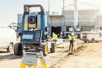
Sokkia Announces New Compatibility with Autodesk Layout Application
LIVERMORE, Calif., USA/ CAPELLE A/D IJSSEL, The Netherlands — Sokkia announces its new iX robotic total station series’ compatibility with the Autodesk BIM 360 Layout application. BIM 360 Layout is designed to provide vertical construction contractors the ability to connect the coordinated model to the field layout process — helping to increase job site productivity, while improving the accuracy of staked or installed building components. “We are committed to the interoperability between o...

Esri Releases EMUs to Understand the Ocean
REDLANDS, Calif.- Esri, the world leader in smart mapping technology, announced a whole new way of measuring the ocean on September 15, 2016, at the Oceans Conference in Washington, DC. Ecological Marine Units (EMUs) are Esri’s gift to a world whose final unexplored terrain lies beneath its seas. Esri and USGS collected a series of global measurements representing the ocean’s physical and chemical properties most likely to drive ecosystem responses. From millions of measurements taken, 37 phy...

Bentley’s AssetWise InspectTech Helps State DOTs and Agencies Achieve Compliance with FHWA MAP-21 Regulations
EXTON, Pa.- Bentley Systems, Incorporated, a leading global provider of comprehensive software solutions for advancing infrastructure, today announced that all 15 state DOTs and agencies using AssetWise InspectTech achieved compliance with annual Federal Highway Administration (FHWA) MAP-21 National Bridge Inventory (NBI) and National Bridge Element (NBE) reporting requirements and successfully submitted reports on time. AssetWise InspectTech delivers accurate element-level inspection data requi...

FARO Introduces Freestyle3D Objects, the First Handheld, Color Laser Scanning Solution Through FARO’s Early Adopter (EA) Program Specifically for the Public Safety Forensics and Product Design Markets
Lake Mary - FARO® (NASDAQ: FARO), the world's most trusted source for 3D measurement and imaging solutions for factory metrology, product design, construction BIM/CIM, public safety forensics and 3D solutions and services applications, introduces the FARO Freestyle3D Objects, a new medium-volume, handheld 3D Laser Scanner for crime/crash scene investigation and reverse engineering applications. With the new powerful Freestyle3D Objects, FARO expands the successful product concept of its const...

FARO Releases High-Resolution Array Imager for Factory Metrology and Product Design Applications
Lake Mary, FL - FARO® (NASDAQ:FARO), the world’s most trusted source for 3D measurement and imaging solutions for factory metrology, product design, construction BIM/CIM, public safety forensics and 3D solutions and services applications, announces the launch of a higher resolution version of the FARO® Cobalt Array Imager solution, geared toward quality inspection, factory automation and in-process verification (IPV) applications. The new 9MP version of the Cobalt Array Imager is a highe...

FARO Releases SCENE Version 6.1, Introducing a Fully Integrated Point Cloud to 3D Mesh Engine for Product Design and Construction BIM-CIM Professionals
LAKE MARY, Fla. - FARO® (NASDAQ: FARO), the world's most trusted source for 3D measurement and imaging solutions for factory metrology, product design, construction BIM/CIM, public safety forensics and 3D solutions and services applications, announces the release of SCENE 6.1, the next generation of its powerful software for efficiently processing and managing 3D laser scan data. For modeling freeform shapes such as statues, equipment, industrial components and buildings, SCENE 6.1 now offer...

Bringing the Civil Engineering Office to the Field Speeds Approvals and Helps Resolve Issues During Design, Construction, and Operations
Bentley Systems announces OpenRoads Navigator CONNECT Edition, an innovative application that provides civil and transportation professionals an easy-to-use, dynamic product for quick access to civil design information in the field. OpenRoads Navigator supports Windows, iOS, and Android. Key capabilities include: View, analyze, and augment a wide variety of project information, including geometry, 3D models, and 2D topography. Search and filter models based on attributes such as...

Trimble Connected Mine Provides Spatial Data Visualization Using Trimble and Microsoft Mixed-Reality Technologies
SUNNYVALE, Calif. —Trimble (NASDAQ:TRMB) announced today the release of its Trimble® Connected Mine™ Visual Intelligence module with support for mixed-reality technology including Microsoft HoloLens to provide visual collaboration of mine spatial data. Trimble Connected Mine is an integrated and complete view of mine data to improve and accelerate operational and strategic decision making. Visual Intelligence is an optional module that enables the 3D visualization of Trimble Connected Mine da...
Buckeye Mountain and Trimble Partner to Bring Mobile Computing, GPS and AEI Tag to Railways
NIWOT, Colo.- Buckeye Mountain and Trimble have been working together in an effort to provide the railroad industry with products that meet their specific needs for mobile computers, AEI (railcar automatic equipment identification tags) and GPS. Trimble's Juno® T41 R-AEI, an all-in-one rugged AEI reader, is a compatible platform for Buckeye Mountain's AEI Quick Read application, a simple and basic mobile application that reads AEI tags. Trimble has the unique capability...
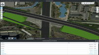
Quickly Produce Conceptual Roadway Designs
Bentley Systems announces OpenRoads ConceptStation, a conceptual modeling application that empowers highway engineering professionals to quickly create conceptual road and bridge models in a matter of hours – not days. OpenRoads ConceptStation enables rapid and iterative conceptual and preliminary design, leveraging contextual information obtained through point clouds, reality meshes, GIS, and other sources. OpenRoads ConceptStation combines engineering drawing tools and project costs to...
Stormwater Interview with Robert Page, P.E., Vice President, HNTB

TriMet’s Banfield Type 1 Substation Replacement Project

February Issue 2026
