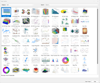
Golden Software Makes Grapher Package Faster to Learn, Easier to Use
Visually search, sort and filter through compact views of sample plots to discover Grapher's possibilities. Visualizing Data, Communicating Results Remain Focus GOLDEN, Colorado – Golden Software, a developer of affordable software for visualizing and analyzing diverse data sets, has focused on improving the user friendliness of its Grapher scientific graphing package for both existing and first-time users. Available today, the new version of Grapher includes enhancements that make it...

Vectorworks 2023 Service Pack 4 Delivers Next-Gen Technology to Designers
Latest Vectorworks Update Furthers Commitment to Providing Designers with Innovative Solutions That Save Time and Accelerate Collaboration Capabilities. Columbia, MD — Global design and BIM software provider Vectorworks, Inc. has released its latest service pack for the Vectorworks 2023 product line, granting users access to next-gen technologies and setting the foundation for further development in future releases. Service Pack 4 also includes new features and capabilities that provide...

AquaFim and WaterIQ Technologies Announce Mexico Partnership
Partnership Increases Access to Advanced Ultrasound Algae Technology WILSON, Wyo. – WaterIQ Technologies™, the leader in next-generation ultrasonic solutions to combat harmful algae and biofilm without the use of chemicals, today announced a partnership agreement with AquaFim, the leading agriculture and irrigation systems and services company for the export produce market in Mexico. As part of the partnership, AquaFim will hold exclusive rights to serve the agricultural irrigation market in...
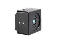
e-con Systems™ launches a new 3D ToF MIPI camera for NVIDIA® Jetson processors
940nm/850nm | MIPI CSI 2 | Multi-camera support| NVIDIA | Depth range upto 12m |
Georeferencing takes center stage for GeoSLAMs latest software release
Enhancements to georeferencing workflows have become the main focal point of GeoSLAMs latest software release, Connect 2.3. The release includes improvements to the Stop and Go Georeferencing workflow, as well as new ways to automatically georeference and align UAV data. The developments come as part of a whole package of new features designed to further improve usability. Adjust to Control The GeoSLAM research and development team set out to incorporate an Adjust to Control interface...
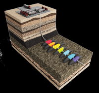
CARBO Ceramics Inc. partners with GEOSPLIT Middle East FZE
HOUSTON - CARBO and GEOSPLIT announced today that the companies have entered into a strategic partnership that will enable energy operators to improve their reservoir performance by optimizing drilling & completions designs through understanding the production inflow profiling. The use of the technology reduces the overall cost of the well's ownership, improves the carbon footprint for the well's lifecycle, and boosts the decision-making of the E&Ps for their offset wells. The agreement combi...
Chung-Ang University Researchers Use Deep Learning to Develop a Forecasting Model for Efficiently Managing Electric Grids
The model accurately predicts uncertain parameters related to renewable energy sources for microgrid operation, their energy demand, and market prices The increasing emphasis on green energy has led to the development of renewable energy sources (RESs). RESs are integrated into power supply systems via microgrids (MGs) whose efficient and profitable operation requires handling uncertainties associated with RESs, energy demand, and market prices. To this end, researchers have recently de...

Immersal Oy launches Immersal City-Scale Visual Positioning System
The new 5G-enabled smart city Visual Positioning System offers unmatched accuracy and new business opportunities for mobile network operators and their customers (Helsinki, Finland & Barcelona, Spain) Immersal Oy, part of Hexagon, announced today at Mobile World Congress (MWC) in Barcelona, Spain, the launch of Immersal City-Scale, a Visual Positioning System (VPS). This innovative solution offers unmatched accuracy in outdoor location-based services for mobile network operators and their ent...
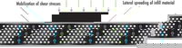
Article Sheds Light on the Power of Geocells in Load Support Applications
Geocells are one of the most valuable tools in the civil engineering and construction industries today. When constructing roadways over soft soils and weak subgrades, geocells can make a significant impact. However, some engineers may be uncertain about using geocells due to a lack of understanding. A recent article aims to clear up any confusion and show the power of geocells in load support applications. The article focuses on the concept of lateral confinement and how it relates to hoop st...
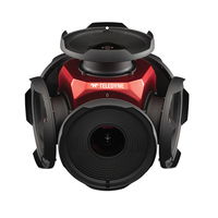
Teledyne’s New Ladybug6 Camera for High-Accuracy 360-Degree Spherical Image Capture Now Shipping
Richmond, CANADA - Teledyne FLIR is pleased to announce its all new Ladybug6 360-degree camera is now in full production. “We are excited to announce that our newest Ladybug camera is in production now and units are shipping immediately. The interest expressed by so many of our long-term customers has been astounding with order commitments made months in advance,” said Mike Lee, Senior Product Manager at Teledyne FLIR. “For applications that require high accuracy imaging like high-definition...
Stormwater Interview with Robert Page, P.E., Vice President, HNTB

TriMet’s Banfield Type 1 Substation Replacement Project

February Issue 2026
