DuPont Consolidates Ultrafiltration Technologies Under New IntegraTec™ Brand
To better serve municipal and industrial customers, DuPont is consolidating and rebranding its diverse portfolio of ultrafiltration (UF) membranes for the sustainable purification, conservation and reuse of water. The DuPont™ IntegraTec™ portfolio of ultrafiltration technologies and products consolidates several legacy ultrafiltration brands– from Inge®, Memcor®, and DuPont Ultrafiltration – into a singular portfolio available to customers. This new offering makes it easier for DuPont’s cu...
Leica Geosystems announces performance upgrades for airborne deep bathymetric surveys
The new Leica HawkEye-5 bathymetric LiDAR sensor provides a significant improvement in flight efficiency for detailed data capture in deep waters (Heerbrugg, Switzerland) — Leica Geosystems, part of Hexagon, announced today the release of the Leica HawkEye-5, the new highly efficient airborne bathymetric LiDAR solution for deep water surveying. The upgraded technology increases survey efficiency by up to 25% compared to previous generations. The Leica HawkEye-5 expands the capabilities o...
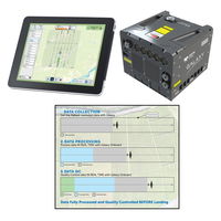
Teledyne Geospatial revolutionizes airborne lidar ROI with Galaxy Onboard: a real-time workflow solution
Vaughan, Ontario, CANADA – Teledyne Geospatial announced the release of the Galaxy Onboard, a workflow-focused solution that enables airborne surveyors to deliver quality-controlled processed data in real time. With Galaxy Onboard, Teledyne Geospatial has lowered the barrier of entry for organizations venturing into airborne mapping with a solution that does not require expertise or months of training. Galaxy Onboard will also offer exceptional value to airborne surveyors allowing them to exp...

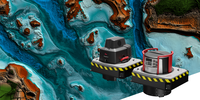
StormTrap’s New Stormwater Treatment Device, StormSettler, Receives New Jersey Department of Environmental Protection Certification Under Latest Protocol
StormSettler, developed by StormTrap, is a highly efficient stormwater treatment settling device that improves the quality of stormwater runoff. ROMEOVILLE, Ill.- StormTrap® announced today the release of the new stormwater treatment device, StormSettler™. The patent-pending treatment device, designed to remove sediment from stormwater runoff, has received New Jersey Corporation for Advanced Technology (NJCAT) verification and NJDEP Certification for online and offline use after su...
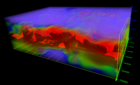
Golden Software Adds Powerful New 3D Subsurface Visualization Functionality to Surfer® Surface Mapping Package
Interpolate and visualize 3D data, such as subsurface soil or groundwater contamination, mineralization concentration, seismic refraction velocity, temperature distribution, or dissolved oxygen concentration. GOLDEN, Colorado – Golden Software’s Surfer package, long known as the geoscience profession’s most powerful 3D surface mapping software, now provides robust subsurface visualization and modeling functionality. In the latest Surfer release – available today – Golden Software has inc...

Esri Releases New ArcGIS Reality Software to Capture the World in 3D
ArcGIS Reality Enables Site, City, and Country-wide 3D Mapping for Digital Twins REDLANDS, Calif.— Business, government, and science organizations increasingly rely on drones, crewed aircraft, and satellites to capture imagery. Detailed imagery data provides visibility into operations and opportunities, unpacking information from every pixel and transforming static pictures into dynamic digital representations of the world. 3D models and high-resolution maps of construction sites, compl...

BAAM.Tech Named North American Reseller for AISPECO’s Next-Generation Infrastructure Inspection Platform
Lenexa, Kansas – BAAM.Tech®, headquartered in Lenexa, Kansas, is pleased to announce that it has executed an agreement with AISPECO from Vilnius, Lithuania to become their North American hardware reseller. BAAM.Tech® will assume sales, training, and technical support services for AISPECO’s Pod – a customizable, multi-vehicle LiDAR and imaging payload solution that is compatible with many FAA-approved aircraft mounts. This system is designed to support quick installation and sensor configurati...
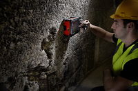
GSSI Showcases GPR Technology at Con Expo 2023
Geophysical Survey Systems, Inc (GSSI), the world’s leading manufacturer of ground penetrating radar (GPR) equipment, will be showcasing its GPR equipment at Con Expo, March 14-18, 2023 in Las Vegas, Nevada. In booth #N12921 GSSI will display its UtilityScan® system, StructureScan Mini XT, and PaveScan RDM 2.0 for the utility, concrete, and transportation industries. The UtilityScan® system makes locating and marking the depth of underground utilities in real-time in the field easier. With r...

Innovations improve field productivity and subcontractor management for better cost and schedule certainty
Newest enhancements to InEight’s construction project management platform bring better forecasting accuracy, improved field collaboration, and more visibility and control over subcontractor performance. SCOTTSDALE, Ariz. – InEight Inc., a global leader in construction capital project management software, has announced its latest suite of software innovations, which are designed to increase forecasting accuracy, field productivity, and subcontractor management. These latest updates pr...
Presagis Introduces VELOCITY 5D Plugin for Unreal Engine
Enables Geospatially Accurate 3D Simulations with Digital Twins Montreal, Canada — Presagis, developer of the VELOCITY 5D (V5D) digital twin production platform, today announced availability of the V5D Plugin for Unreal Engine, the most powerful 3D computer graphics engine on the market today. The plugin enables users to load a GIS-generated V5D digital twin into Unreal Engine to create highly realistic visualizations and simulations of entire cities and even countries. “The primary applic...
Stormwater Interview with Robert Page, P.E., Vice President, HNTB

TriMet’s Banfield Type 1 Substation Replacement Project

February Issue 2026
