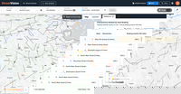
Cambridge Mobile Telematics Expands StreetVision With Intersection Safety Insights and Integrated Crash Data
Helps safety officials and state agencies identify risk faster to prevent crashes with the industry’s first platform that fully integrates crash and fatality records with driving behavior analyticsCambridge, MA — Cambridge Mobile Telematics (CMT), the world’s largest telematics provider, today announced new capabilities in StreetVision that help transportation agencies identify high-risk intersections, prioritize safety investments, and prevent crashes before they happen. CMT now provides inters...

Trimble Unveils 2026 Tekla Software: Accelerating BIM, Engineering and Construction Productivity Through Streamlined Workflows and AI
From office to site, Tekla is redefining how structures are designed, fabricated and built, combining automation and seamless collaboration into a connected construction workflowWESTMINSTER, Colo. — Trimble today introduced the 2026 version of its Tekla® software for constructible Building Information Modeling (BIM), structural engineering and steel fabrication management, delivering data-driven workflows that connect design and construction. This release accelerates the entire design-to-detaili...

ACE Welcomes Updated NISTA Pipeline
ACE has today welcomed the publication of the updated NISTA (National Infrastructure and Service Transformation Authority) pipeline, describing it as an important step in providing greater visibility and certainty for the UK’s infrastructure and public service transformation agenda. With higher quality data, the new pipeline provides a clearer forward look at planned projects and programs in government, which will help businesses, investors, and delivery partners better understand future opportu...
Vexcel Intelligence Gives AI Eyes, Making the World Searchable for the First Time
First-of-its-kind platform brings vision to AI through high-resolution aerial imagery, making the physical world searchable for the first time.DENVER - AI can summarize the internet. Now it can understand the Earth. Vexcel today launched Vexcel Intelligence, a breakthrough AI platform trained on continuous high-resolution aerial imagery that allows organizations and AI systems to search and reason against the physical world for the first time."Until now, AI has relied on what's been captured onl...
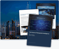
Eagleview White Paper Warns: Geospatial Intelligence Is About to Change Forever
From conversational AI to agent-driven systems, the report says maps are becoming obsolete and decision-making is moving to machine speed.Rochester, NY, Mar 04, 2026 - Eagleview, a leader in aerial imagery and geospatial intelligence, today released a new executive briefing warning that geospatial intelligence (GEOAI) is entering the most consequential transformation in its history. Within the next twenty years, the industry will fundamentally change how organizations see, understand, and act on...
Leica Geosystems and Liebherr expand factory-integrated machine control for Generation 8 crawler and mobile excavators
(LAS VEGAS, USA) Leica Geosystems, part of Hexagon, and Liebherr today announced a major expansion of their long-standing collaboration with the factory integration of Leica Geosystems’ sensor chain across Liebherr’s Generation 8 mobile and crawler excavators as per default. The new solution is available ex-factory, providing contractors with immediate productivity benefits and a clear upgrade path to advanced 3D machine control.The integrated sensor chain from Leica Geosystems will serve as the...

Rand Simulation Named an Ansys Apex Channel Partner
Rand SIM Earns Top Ansys Simulation Partner Status Baltimore, MD – Rand Simulation, a leading provider of engineering simulation solutions and services, has achieved Ansys Apex Channel Partner status, the highest designation within the Ansys Channel Partner Program, now part of Synopsys. This recognition reflects Rand SIM’s advanced technical expertise, proven customer success, and a sustained commitment to helping organizations achieve measurable business outcomes through simulation.“For our cu...

Jeju scales hydrogen as energy storage with KraftPowercon’s 5 MW rectifier solution
Jeju Island is becoming an important testbed for industrial-scale hydrogen production in Korea, with renewable-heavy power conditions that can challenge large electrolysis loads. In that environment, power conversion becomes critical to stabilizing the interface between the grid and the electrolyzer stacksIn connection with an electrolyzer system being built by HyAxiom, Inc. for a hydrogen production project on Jeju Island, KraftPowercon has been selected to supply a 5 MW-class rectifier system...

Leica Geosystems expands 3D machine control compatibility options for Caterpillar Next Gen Wheeled Excavators
Leica Geosystems, part of Hexagon, expands 3D machine control compatibility to Caterpillar Next Gen Wheeled Excavators.The Leica MC1 solution boosts accuracy, efficiency, and sustainability across Caterpillar equipment.Available March 2026, the new aftermarket system streamlines installation and enhances performance. HEERBRUGG, SWITZERLAND: Leica Geosystems, part of Hexagon, today announced the expansion of its offerings to deliver advanced aftermarket 3D machine control solutions for Caterpilla...
Advanced Navigation Launches Chimera Land: A Laser Velocity Breakthrough in Uncharted Underground Mining
Global - Advanced Navigation, a global leader in autonomous systems, has announced the launch of Chimera Land. A new class of navigation, this 3D Laser Velocity Sensor (LVS) is specifically designed to solve the primary challenge for underground mining: maintaining precise vehicle positioning in deep, dark, and unmapped environments where GPS cannot reach.In underground mining, knowing exactly where a vehicle is located is mission-critical. Traditional navigation relies on GPS signals, which dis...
Stormwater Interview with Robert Page, P.E., Vice President, HNTB

TriMet’s Banfield Type 1 Substation Replacement Project

February Issue 2026
