
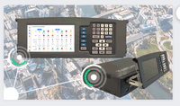
Leica Geosystems introduces the next evolution in smart, autonomous mobile mapping
(Heerbrugg, Switzerland, 2 May 2023) Leica Geosystems, part of Hexagon, today announced the latest addition to its Leica Pegasus TRK portfolio of mobile mapping solutions, the Leica Pegasus TRK100. Specifically designed for GIS professionals, the new mobile mapping system is a powerful, easy-to-use geospatial solution built for large-scale infrastructure measurement and digital twin creation. The Pegasus TRK portfolio is renowned for its simplicity and ease of use, lightweight robust design,...
Teledyne launches CARIS Cloud to support S-100 production
Fredericton, NB, CANADA: Teledyne Geospatial, a Teledyne Technologies company, is pleased to announce the release of three new applications on its CARIS Cloud platform—the CARIS Bathy Data Service, S-57 ENC Service, and Chart Data Service. The robust and scalable CARIS Cloud allows for the management, processing, and distribution of hydrospatial data, all from one platform. Leveraging CARIS Cloud accelerates and automates product delivery, enabling hydrographic offices to focus on planning a...

NEW WEBSITE LAUNCHED TO PROMOTE CAREERS IN CONSTRUCTION
Englewood Cliffs, NJ.- Those Amazing Professions Inc. (TAP) announces the launch of www.thoseamazingbuilders.com, a website created to interest young people in careers in the construction industry. The site highlights the work and wisdom of construction professionals at all levels, their accomplishments and challenges, and their advice to those considering a career in the industry. The publicly available site was developed with funding and support from major construction industry firms and organ...

SimActive Releases Correlator3D Version 10 with High Density Point Cloud Generation
Montreal, Canada, April 26th, 2023 – SimActive Inc., a world-leading developer of photogrammetry software, announces the release of Correlator3D Version 10. In addition to a completely redesigned user interface with a new dark mode option, point clouds can now be generated at significantly higher densities. New capabilities also include adding oblique imagery to improve results, colorizing photogrammetric point clouds during their generation and advanced filtering to eliminate less accurate p...

Aurigo Masterworks Cloud Achieves FedRAMP In Process Status
AUSTIN, Texas, April 20, 2023—Aurigo Software, the leading provider of capital planning and construction management software for infrastructure and private owners, today announced that their flagship product suite, Aurigo Masterworks Cloud, has reached In Process status on the Federal Risk and Authorization Management Program (FedRAMP®) marketplace. Aurigo’s software will provide federal agencies with enhanced security and monitoring capabilities, helping accelerate digital transformation for so...
ITSA: Yunex Traffic Launches the Yutraffic Blade in the U.S. – The First Edge Computing Traffic Controller on the Market
Introducing the Yutraffic Blade, the only edge computing traffic controller on the market today A powerful engine and quad-core processor enable the Yutraffic Blade to grow and expand with traffic management technologies. The Yutraffic Blade’s combines multiple 3rd party devices into a singular platform saving crucial resources and space at the cabinet. It was built with security at the forefront and can operate in zero-trust environments. Dallas, TX April 20, 2023 - Yune...
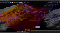
HEAVY.AI Launches HEAVY 7.0, Introducing Industry-First Machine Learning Capabilities
HEAVY 7.0 supercharges analytics for telcos and utilities with groundbreaking predictive modeling features, improved HEAVY Immerse experience, and enhanced HeavyRF operational configuration SAN FRANCISCO – HEAVY.AI, an innovator in advanced analytics, today announced general availability of HEAVY 7.0. The new product adds innovative machine learning capabilities, enabling telcos and utilities to perform in-database predictive modeling and simulate any scenario to uncover key insights. HEAVY...

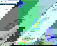
Underground mapping for flood modeling with mobile LiDAR
Mobile LiDAR scanners are mapping underground spaces in Belfast to better understand and prepare for coastal flooding. The use of innovative technology provides greater clarity of large flood risk areas for surveyors, through the creation of flood models. With sea levels predicted to rise 12 inches by 2050, sufficient flood defenses and a better understanding of water flow help to mitigate risk to coastal towns and cities. Globally, LiDAR solutions help to create the foundations for flood m...
EIVA launches cloud-based thin client for efficient NaviSuite project data sharing and viewing
DTM and 3D model visualised in NaviSuite Cloud Viewer EIVA has launched a cloud-based thin client, NaviSuite Cloud Viewer, enabling NaviSuite users to share project data with end clients in a web browser. This provides powerful data visualisation for operators and end clients – and eliminates the need to download any third-party programs. With this, operators can give their end clients the ability to easily navigate projects using high-performance data visualisation capabilities, such...
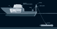
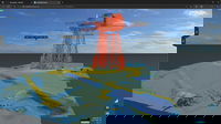
EIVA launches ROTV enabling autonomous USV systems to collect high-resolution data even in narrow areas
Concept illustration of ViperFish EIVA has launched a new remotely operated towed vehicle (ROTV): ViperFish. This all-in-one sensor platform is tailored for autonomous unmanned surface vehicle (USV) systems. With its compact, streamlined design and precise 3D control, ViperFish can safely survey narrow, hard to reach areas , with stable sensors close to the seabed for optimal data collection. ViperFish uses the same electronics and flight control as the industry-...
Stormwater Interview with Robert Page, P.E., Vice President, HNTB

TriMet’s Banfield Type 1 Substation Replacement Project

February Issue 2026
