EarthCam Announces Eighth-Generation Integration with Autodesk Construction Cloud
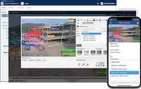
SAN DIEGO, October 17, 2024 – EarthCam, the leader in live camera technology, content and services, today unveiled its eighth-generation integration with Autodesk Construction Cloud®, a portfolio of software and services that combines advanced technology, a builders network and predictive insights for construction teams, coinciding with Autodesk University. EarthCam has improved speed and precision for its unique alignment of live video streams with BIM models and digital twins, enabling VDC (vi...

Matterport’s Fall 2024 Release: Insights Meets Imagination
Matterport introduces essential new tools for real estate agents, contractors and designers. Today, Matterport is proud to unveil a groundbreaking suite of new tools that will reshape the way real estate is designed, built, managed and marketed. As we hope you’ve experienced, Matterport has been evolving in recent years from a platform that captures the built world as it is to one that helps users unlock the future potential of a space—whether that’s a home, an office suite or a fa...

ALLPLAN 2025: Revolutionizing Design and Construction with AI-Powered Tools and Real-Time Collaboration
The AI Visualizer provides inspiration in the early stages of design by testing different architectural styles, and in the later stages of design by visualising furniture and materials. Copyright: ALLPLAN Seamless and innovative workflows for substantially increased productivity across all disciplines Munich, October 15, 2024 – ALLPLAN has launched its latest version of BIM software, setting a new standard in design and construction workflows. ALLPLAN 2025 introduces advanced features...
Golden Software Improves Grapher Scientific Graphing Package for Greater Ease of Use, Faster Learning
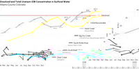
Grapher users can now more clearly demonstrate multifaceted data insights with enhanced visualization functionality, as in this review of uranium concentrations in surface water sources in Adams County, Colorado. GOLDEN, Colorado, 10 October 2024 – Golden Software, a leading developer of mapping, plotting, and visualization software, has improved numerous features in its Grapher scientific graphing package to provide greater ease of use to both long-time and first-time users. In addition...

Nearmap Elevates Location Intelligence with New Generation of AI-Derived Insights
SALT LAKE CITY — Nearmap, a global leader of location intelligence, has released its latest version of AI, Generation 6 (Gen 6), which empowers customers across multiple industries to make smarter, more informed decisions with 130+ AI-derived, location-based detections and scores. As the only full-stack SaaS provider of location intelligence, Nearmap provides its customers with the imagery, AI-derived insights, and answers needed to solve their specific business challenges. Trained on millio...

Bentley Systems: Open Data Ecosystems to Advance Infrastructure Engineering
OpenTower iQ, part of Bentley’s Asset Analytics product portfolio, allows multiple data layers to inform better decision-making. This image compares the as-built model to the as-designed model. (Photo: Bentley Systems) At its Year in Infrastructure conference, Bentley highlights the value of open data ecosystems to improve infrastructure resilience and sustainability VANCOUVER (Bentley Systems’ Year in Infrastructure 2024) — Bentley Systems, Incorporated (Nasdaq: BSY), the infras...
Bentley Systems Announces Generative AI Game-Changer for Civil Site Design
Bentley’s OpenSite+ software uses AI to automate annotation and plan production for civil site design. (Photo Bentley Systems) Company unveils first-to-market AI-powered civil engineering application that delivers optimized, accurate site designs up to 10 times faster than traditional methods VANCOUVER (Bentley Systems’ Year in Infrastructure 2024) – Bentley Systems, Incorporated (Nasdaq: BSY), the infrastructure engineering software company, today announced new generative AI c...
Bentley Systems’ New Carbon Analysis Capabilities Help Reduce Infrastructure’s Carbon Footprint
Example of Bentley’s Carbon Analysis capabilities: Embodied carbon grouping of common components for reporting (Photo: Bentley Systems) Bentley makes carbon impact analysis a systematic part of the design process for new and existing infrastructure assets, simplifies embodied carbon reporting with added 3D visualizations VANCOUVER (Bentley Systems’ Year in Infrastructure 2024) – Bent...

Bentley Systems Partners with Google to Bring Powerful Geospatial Context and Capabilities to Infrastructure
Collaboration enables use of Google 2D, 3D geospatial content within Bentley’s applications and platforms to deliver actionable insights to infrastructure professionals VANCOUVER (Bentley Systems’ Year in Infrastructure 2024), October 9, 2024 — Bentley Systems, Incorporated (Nasdaq: BSY), the infrastructure engineering software company, today announced a strategic partnership with Google to integrate Google’s high-quality geospatial content with Bentley’s infrastructure engineering software...

AGTEK launches Reveal Maps
The newest innovation on AGTEK’s Reveal platform creates simple verifiable drone models for heavy construction Livermore, California, USA, 08 October 2024 – AGTEK, part of Hexagon, today announced the release of Reveal Maps, the latest innovation in its Reveal platform. This new application allows heavy construction professionals to generate 3D point clouds and orthomosaic maps from their RTK drone flights through simple, intuitive and verifiable workflows. Once a drone flight is complete,...
Stormwater Interview with Robert Page, P.E., Vice President, HNTB

TriMet’s Banfield Type 1 Substation Replacement Project

February Issue 2026
