
Digital Twin Consortium Unveils Updated Definitions
Harmonizing digital twin and digital thread capabilities with core digital engineering principles BOSTON, MA – OCTOBER 3, 2024 – Today, the Digital Twin Consortium® (DTC) announced revised definitions for digital twin and digital thread, aligning these concepts more closely with core digital engineering principles. These refined definitions underscore the central role of digital twins and digital threads in advanced digital engineering disciplines and methodologies, highlighting their importanc...

Survipod Engineering Adds Innovative Innogain Former to Its Surveying Equipment Range
Research shows new design reduces survey errors by 200% Survipod Engineering, a leader in innovative surveying solutions, is proud to announce the launch of its latest product, the Survipod Innogain Former - the latest addition to its highly rated range of precise surveying tools. Research shows the pioneering new design can reduce surveying errors by as much as 200%, meaning it delivers tangible cost and time savings. The Survipod Innogain Former is poised to set a new benchmark in t...
HCSS Announces Integration Capabilities with Microsoft Intune
Integration Allows Secure Management of HCSS Plans and Field Apps on Mobile Devices in Heavy Civil Construction Applications SUGAR LAND, Texas — HCSS, the leading provider of software helping heavy civil construction businesses streamline their operations, is proud to announce that two of its core mobile applications, HCSS Plans and HCSS Field, are now fully integrated with Microsoft Intune. This inclusion enhances the management and security of HCSS applications on iOS devices for Intun...
Siemens launches digital decarbonization tool at Climate Week NYC to help simplify the path to net-zero facilities
The Decarbonization Business Optimizer (DBO™) provides baseline carbon assessments and more efficient pathways to net-zero emissions based on location, type and size of commercial and industrial facilities • Integrates verified data sets and tools from the US Department of Energy, Environmental Protection Agency, and National Renewable Energy Laboratory • Built on Amazon Web Services (AWS) using serverless architecture to minimize the tool’s carbon footprint Today, Siemens Financial Service...

New single photon LiDAR technology boosts the efficiency of large-area airborne mapping projects
With over 14 million measurements per second, the new SPL can produce high-resolution point clouds for detailed modelling of the ground and surface features (Heerbrugg, 24/09/2024) Leica Geosystems, part of Hexagon, today announced a new high-performance single photon LiDAR (SPL) technology that can be integrated into hybrid sensors to boost the efficiency of country-wide geospatial data collection. With an expanded 60-degree field of view and over 500 measurement channels, the new s...

Trimble and Worldsensing Collaborate to Expand Monitoring Solutions with Wireless GNSS Sensors
Mining, construction and infrastructure industries to benefit from real-time data analysis, and time and cost savings WESTMINSTER, Colo. & BARCELONA, Spain, September 23, 2024 – TrimbleⓇ (NASDAQ: TRMB) and Worldsensing announced today the introduction of a solution for long term 3D ground and structural movement monitoring that will combine Trimble 4D Control™ (T4D) monitoring software with the new Trimble GNSS Meter, powered by Worldsensing. Designed for the mining, construction and infrast...

Virtual Surveyor Adds Productivity Tools to Mid-Level Smart Drone Surveying Software Plan
Line survey in a quarry generated with the guided breakline feature. Create Surveys Faster at the Same Cost AARSCHOT, Belgium – Virtual Surveyor has significantly reorganized its smart drone surveying software plans with the addition of the Productivity Tools suite to the Ridge plan. Previously available only in the highest-level subscription package, the Productivity Tools enhance the speed of creating survey products from UAV-derived images and LiDAR data. Virtual Surveyor software pr...
Hexagon releases new on-demand geospatial data products on HxDR and integration with GIS applications
New developments in the Hexagon Digital Reality (HxDR) platform heighten the convenience and broaden access to on-demand geospatial content from the Content Program, Hexagon’s library of 2D and 3D aerial datasets. (Heerbrugg, Switzerland, 23 September 2024) Hexagon’s Geosystems division announced today that new 2D and 3D geospatial data products are being added to the HxDR platform. In addition, HxDR now provides expanded delivery options for on-demand content. The Hexagon Content Program i...
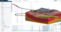
Leapfrog evolution supports geoscience professionals tackling increasingly complex civil and environmental projects
Caption: Downhole survey data can now be visualised to aid drilling data analysis in Leapfrog Works Leapfrog evolution supports geoscience professionals tackling increasingly complex civil and environmental projects Seequent, The Bentley Subsurface Company has unveiled a considerable update to its industry-leading 3D earth modelling and analysis tool Leapfrog. The new functionality enhances core tools and workflows to improve productivity and help solve a range of geoscience challenges in c...
Comcast Smart Solutions Expands Offerings with Smart Access Control Category
Customers across multiple industries can now benefit from Brivo's door stations, video-enabled intercoms, and visitor management solutions to help enhance asset and data management PHILADELPHIA, PA – Comcast Smart Solutions, a division of Comcast Cable (NASDAQ: CMCSA) that specializes in smart technologies for businesses and communities, today expanded its offerings to include smart access control. Comcast Smart Solutions is now offering cutting-edge smart access management solutions to its cus...
Stormwater Interview with Robert Page, P.E., Vice President, HNTB

TriMet’s Banfield Type 1 Substation Replacement Project

February Issue 2026
