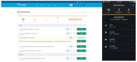
New in Skyward: Risk Assessment for Safer Drone Operations
Every aviation operation wants to maintain a low risk profile, and corporate drone programs are no exception. But tracking and recording risk across distributed teams flying dozens of missions is a big challenge. That’s where Skyward’s Aviation Management Platform comes in. We help you manage all your drone flights, personnel, aircraft, and more. And with our brand new risk assessment tool, we’re helping drone program managers proactively identify and document critical risks to an operation....

New in Skyward: Live Flight Tracking for Drone Operations
Over the last few months, Skyward has been hard at work on the latest developments in our Aviation Management Platform. Today, I’m excited to announce a brand new feature to support program oversight and risk mitigation: Live Flights. With today’s release, you can monitor your drone flights anywhere you have connectivity: from the office, the field, or even at home. Live Flights also serves as a foundation for Skyward’s implementation of Remote ID. You can learn more about Live Flights and ot...

Coast-to-Coast U.S. Coverage Now Deployed for Trimble’s CenterPoint RTX Fast Correction Service
Trimble’s CenterPoint RTX U.S. and Canada coverage map One-Inch GNSS Accuracy in Under a Minute, Delivering Seamless High-Precision Performance Across the U.S. and Southern Canada SUNNYVALE, Calif. —Trimble (NASDAQ: TRMB) announced today the completion of the breakthrough expansion of its CenterPoint® RTX Fast correction service, with coverage now spanning the contiguous U.S. and southern Canada. This expansion is central to Trimble’s vision to transform how and where users can l...
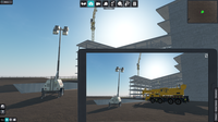
Mott MacDonald launches collaborative design and construction VR tool Rehearsive
Mott MacDonald has launched Rehearsive, a new virtual reality (VR) and desktop product that helps users rehearse their construction and operational processes ahead of time, unlocking safer, buildable design. It allows infrastructure designers and operators to walk through construction scenarios with their team and delivery partners in VR and desktop, no matter their location. The launch follows a successful three-month beta test with 250 volunteers from across the UK infrastructure sector. With...

Taqtile Announces Manifest 2.0
New features, Expert Connect and Working Together, allow for optimized communication and increased collaboration between remote workers SEATTLE — May 5, 2020 — Taqtile, the leading provider of enterprise software for industrial workers, today announces the 2.0 release of their flagship product Manifest. Manifest is an end-to-end spatial computing solution delivering digital transformation and productivity to frontline employees enabling the capture and sharing of knowledge in a simple,...

Inpho version 10.0.3 now available
Trimble Inpho version 10.0.3 is now available and features an increased stability of the modules in Inpho version 10, including improvements to camera setup and stereoscopic viewing in UASMaster and DTMaster, stability in OrthoMaster, as well as a better matching of analogue photos. Further information can be found in the release notes for Inpho and UASMaster. Customers working from home that encounter issues using Inpho software via a Windows Remote Desktop Connection should contact imaging_...
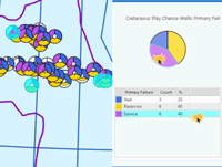
Enhanced Exprodat Software for ArcGIS Pro Provides Increased Exploration Insight
Exprodat, the Esri software oil and gas specialist, has released an enhanced version of its Exploration Analyst software for ArcGIS Pro. This updated version of the popular software that allows oil and gas geologists and geophysicists to make better exploration decisions provides a range of new tools and features which further enhance these critical workflows. Key to play based exploration (PBE) workflows is understanding how results of previously drilled wells inform the future prosp...

Trimble Introduces the Next Generation of Paving Control for Asphalt Pavers
Trimble Roadworks 2D Paving Control Platform Advances Machine Control with Integrated 2D Aftermarket Asphalt Paver Automatics SUNNYVALE, Calif.— Trimble (NASDAQ:TRMB) announced today Trimble® Roadworks 2D Paving Control Platform for asphalt pavers, an automatic screed control system that can improve the accuracy and productivity in applications of asphalt paving. Trimble Roadworks enables paving contractors to minimize the waste of expensive asphalt material, achieve optimal rideability resul...

Interview with Esri President Jack Dangermond
In November 2019, Informed Infrastructure Editorial Director Todd Danielson interviewed Esri President Jack Dangermond at the Autodesk University (AU) Conference in Las Vegas.

Black & Veatch’s Connected Data Real-Time Mapping Technology Keeps Projects Moving and Workers Safe
OVERLAND PARK, Kan. - Black & Veatch, a global provider of engineering, procurement and construction (EPC) services, has developed a geospatial tracking tool to additionally safeguard field services and construction crews during the current COVID-19 global health crisis. The rollout of “BV Safe Contact” comes at a time when essential power, water and telecommunications services are in high demand, making large infrastructure projects more critical than ever. Because project work must continue...
Stormwater Interview with Robert Page, P.E., Vice President, HNTB

TriMet’s Banfield Type 1 Substation Replacement Project

February Issue 2026
