RoadBotics Introduces Image Logger on Asset Management Operating System
PITTSBURGH, PA – RoadBotics is announcing the addition of Image Logger to its growing suite of products to help communities digitize their assets including roads, sidewalks, trails, and more. This innovative technology places time-stamped geo-spatial image data on a GIS-enabled map, creating an easy way for communities to view all of their public assets on one platform. Viewable from a desk or out in the field, Image Logger maps simplify decision making, saving users time and money. “The Im...
How the Digital Twin Market is set to grow to $35.8b pa over the next few years
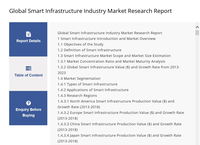
A recent Markets & Markets report estimated the Digital Twin market will grow from $3.8 billion in 2019, to $35.8 billion per year by 2025, at a CAGR of 45.4%. Digital Twin software is already revolutionizing industries such as Healthcare, Architecture, Aerospace, Defence, and Automotive & Transportation. Furthermore, the global Smart Infrastructure market, which includes the Digital Twin sector, is expected to thrive at a considerable CAGR between 2020 and 2025 as demand for the Smart Infras...

Monograph Launches New Forecasting Features
Firm management software provides comprehensive project status and budgeting tools for AEC firms San Francisco, CA — June 2020 — Monograph, a San Francisco-based technology company innovating the way architects and engineers oversee projects, timesheets and forecasts, is pleased to announce two important software features. Designed to support connected workflows and improve forecasting capabilities, the new Project Status categorizations and Project Planner are a direct response to curre...

Grand Opening Today for Old Hilliard’s Franklin Street, Redesigned by Woolpert
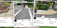
These before-and-after photos illustrate the renovation of Franklin Street in Hilliard, Ohio. The city will host a ribbon-cutting event with walking tours and local vendors from 4:30-6:30 p.m. HILLIARD, Ohio — The grand reopening of Franklin Street will take place from 4:30-6:30 p.m. today, June 17, at the corner of Franklin and Main streets in Hilliard, Ohio. Woolpert provided engineering, design and survey services for the redesign of the roughly 600-foot st...

Ideate Software Applications Now Aligned with Autodesk Revit 2021
San Francisco, CA – Ideate Software, a veteran Autodesk Developer Network member, announced enhancements to its Revit productivity applications. “As we do every year, we launched updates to all our products shortly after Autodesk released its newest version of Revit software,” said Glynnis Patterson, Director of Software Development. “In addition to aligning our software with Revit 2021, we added enhancements requested by Revit users around the world. One of the most significant changes is wi...
Virtual Surveyor Drone Surveying Software Simplifies Workflow for Earthworks Monitoring at Construction Sites
Fast Cut-and-Fill Calculations AARSCHOT, Belgium, 15 June 2020 – Virtual Surveyor has introduced new functionality in Version 7.3 of its popular drone surveying software to create a simplified workflow for monitoring earthworks progress at construction sites. The productive workflow enables construction managers to quickly calculate cut-and-fill changes over time for comparison with the Earthworks design plan. “Drones are an inexpensive and accurate way to monitor the movement of dirt...

CHC Navigation Introduces BB4 UAV and AlphaUni LiDAR Series
Shanghai, China - CHC Navigation (CHCNAV) announced today the launch of the new multi-rotor BB4 drone and AlphaUni 300/900/1300 LiDAR. The groundbreaking combination of the AlphaUni 300/900/1300 LiDAR and BB4 UAV solutions creates one of the most comprehensive and versatile ranges for 3D mapping and geospatial data acquisition in land, air and marine applications. "The purchase of a 3D mobile mapping system is too often constrained to a specific purpose, such as airborne or ground survey. A...

CUES New Product – GraniteNet WebInspect Browser-Based App
Orlando, Florida, USA: CUES is proud to offer GraniteNet WebInspect, a browser-based inspection app. to perform inspections and collect information about municipal assets, such as manholes, including MACP v7 Level 1, hydrants, lift stations, grease traps, light poles, signage, etc. Perform and track tasks such as valve turning, smoke tests, brush cutting, snow plowing, etc. Collect GPS points, water quality samples, flow tests, assess sewer backups, etc. - virtually any type of asset assessme...
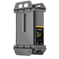
Trimble Offers New Solutions-as-a-Service Program for Remote Monitoring of Water and Wastewater Infrastructure
SUNNYVALE, Calif.,- Trimble (NASDAQ: TRMB) announced today the availability of its remote monitoring IoT hardware and software solutions offered as a service for water and wastewater utilities. With this new program, water and wastewater utilities, through a subscription, can access the latest in hardware and software technologies for remote monitoring of critical infrastructure. A New and Simplified Approach for Monitoring Critical Infrastructure As an alternative to the traditional appro...

Doosan Bobcat Partners with Ainstein to Develop Radar Sensor Technology for Compact Equipment
Strategic partnership will leverage state-of-the-art technology for autonomous operations WEST FARGO, N.D –Doosan Bobcat North America announced today it has partnered withAinstein AI, Inc., a radar technologies company headquartered in Lawrence, Kan., to develop next-generation radar sensor systems for Bobcat® equipment. Through this partnership, Ainstein and Doosan Bobcat North America will collaborate to create radar-based sensing solutions to detect objects and people on job sites. “Th...
Stormwater Interview with Robert Page, P.E., Vice President, HNTB

TriMet’s Banfield Type 1 Substation Replacement Project

February Issue 2026
