
elec calc™ 2020: Electrical Calculations Made Easy
Trace Software International announces that the latest version of elec calc™ is already available on the market. The software guarantees the optimal sizing and the calculation performance in real-time of any electrical installation. The newest version has been enhanced with new automation features, the result of the company’s decades of know-how in the industry. Since 1987, Trace Software International has focused its efforts on designing software solutions to help engineering professionals e...
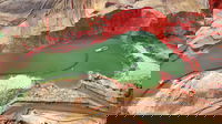
Newest Virtual Surveyor Software Highlights Dangerous Slope Angles in Sand Pits, Quarries, Escarpments
Focus on Safe Operations AARSCHOT, Belgium – Virtual Surveyor has introduced a new feature in Version 7.2 of its popular drone surveying software that automatically highlights terrain slopes that exceed dangerous steepness thresholds. Called Slope Threshold lens, this capability significantly enhances the safety of operations in sand pits, quarries and other dynamic environments with steep terrains. “With the click of a button, operators of sand pits and quarries can see precisely where the...
InnerSpace Announces inFORCE Public Health & Safety Solution
Indoor location platform provides municipalities with emergency response and public safety solutions on existing WiFi networks TORONTO (ON) - InnerSpace, the world’s most accurate WiFi-based indoor location intelligence platform, today announced its product capabilities to support all levels of government to analyze the patterns and movement in public spaces using existing WiFi networks. The platform is ideally suited to understand the movement of people inside pu...

Leica Geosystems announces new 3D laser scanning bundle
Leica Geosystems, a Hexagon company, announced today a new 3D laser scanning bundle for the BLK360 and greater integration with Autodesk ecosystem. HEERBRUGG, Switzerland – Leica Geosystems, a Hexagon company, announced today a new 3D laser scanning bundle for the Leica BLK360 and greater integration with Autodesk ecosystem. This new bundle consists of the Leica BLK360 imaging laser scanner, Leica Cyclone REGISTER 360 (BLK Edition) desktop software, and Leica Cyclone FIELD 360 for tab...

Plexscape’s response to COVID-19 pandemic: Free Plex.Earth licences for remote working
In response to COVID-19 pandemic, Plexscape, developers of Plex.Earth®, one of the most popular AutoCAD tools for the acceleration of architectural, engineering and construction (AEC) projects, is doubling its customers’ licenses at no extra cost, for the next 3 months. This initiative aims to help thousands of Plex.Earth users in more than 120 countries worldwide to have a smooth transition to the new remote-work conditions by installing the software on their home computers or laptops, free of...

SOLV3D Embraces Market and Client Requirements in Their Latest Product Release
CALGARY, AB – March 31, 2020 – SOLV3D, a leading provider of 3D processing, geospatial data visualization and collaboration solutions, is pleased to announce the immediate availability of version 2.2.1.1937 of SOLV3D encompass™ (Encompass) and version 3.0.2 of SOLV3D engine™ (Engine). The releases incorporate a number of new features and enhancements. “Much of this release can be attributed to the feedback and input we’ve received from the many partners and clients we are working with.” stat...
Pix4D Announces a New Generation of Tools for Photogrammetry, Drone Mapping and Analytics
Lausanne, Switzerland, March 31st, 2020: Photogrammetry leader Pix4D is announcing today the commercial release of next-generation software addressing the modern-day professional challenges. Developed in close collaboration with customers and partners, Pix4Dsurvey, Pix4Dmatic, Pix4Dinspect, and Pix4Dscan will contribute to revolutionizing the way professional customers operate and deliver their services. Breaking ground with Pix4Dsurvey & Pix4Dmatic Digital photogrammetry is an essential p...

State Governments in the U.S. Using Vexcel Imagery to Aid in COVID-19 Response
United States : The worldwide COVID-19 pandemic has now reached all 50 states in the U.S. In accordance with Federal Government and Center for Disease Control and Prevention (CDC) mandate social distancing is being put in place throughout the nation. As announced on March 17, 2020, state and federal government agencies have been given no-cost or obligation access to high-resolution aerial imagery and related geospatial information captured by Vexcel Imaging to support their responses to the...

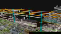
Dynamic Infrastructure responds to coronavirus and allows free use of its AI-based bridge maintenance technology
Transportation should keep moving: Dynamic Infrastructure responds to coronavirus pandemic and allows free use of its AI-based bridge maintenance technology by DOTs and PPPs worldwide The New York and Tel Aviv based company Dynamic Infrastructure has decided to open free of charge its AI-based technology to enable Departments of Transportation and Private Public Partnerships (PPP) to continue to remotely manage the critical maintenance of bridges and tunnels during the global emergency r...

Eka Releases Free COVID-19 Risk Monitoring App
Press Release: New York: Eka Software Solutions, the #1 cloud platform for commodity management, announced the release of COVID-19 Risk Monitoring, a free app designed to help customers and prospects quickly gain visibility into supply chain risks to better assess and mitigate risk. The app provides specific insights into the impact of COVID-19 by showing a company’s contract position across countries with reported cases of the virus. Based on company data, the app instantly visualizes contracts...
Stormwater Interview with Robert Page, P.E., Vice President, HNTB

TriMet’s Banfield Type 1 Substation Replacement Project

February Issue 2026
