
Presto Announces Ballast Research Performance Results
Presto Geosystems, industry-leading manufacturer of the HDPE GEOWEB® base stabilization system, has released results from rigorous track research performed to quantify the reinforcement benefit of GEOWEB-confined ballast as compared to unconfined ballast. The research initiative was a cooperative effort between Oregon State University (OSU) and the University of Kansas (KU) under the direction of Ben Leshchinsky, PE, PhD and Jie Han, PE, PhD. The results substantiate the effectiveness of GEOWEB...

Resilience In Action: Get Severe Weather Protection From Closed-Cell Spray Foam Insulation
When people think of disaster mitigation they often think of roof systems, shutters, and impact resistant glass. But what is behind the walls can have an enormous impact on what happens to a home in a weather event. Closed-cell spray polyurethane foam insulation (ccSPF) is the ideal insulation for hurricane and severe weather zones. The product: Adds structural strength Provides wind uplift resistance Offers water resistance Is cost-effective Is easy to install Provides du...

BuildSteel Releases e-Book with Proactive Tips to Minimize Construction Impacts from Fire, Cold Weather, Hurricanes and Flooding
WASHINGTON, D.C. (Feb. 13, 2018) – BuildSteel, a partnership of steel and construction industry organizations, announced the release of “Strength in the Face of Disaster: How Cold-Formed Steel Framing Keeps Buildings Safe,” a free e-book exploring the durability and resiliency of cold-formed steel (CFS) framing when confronted with fire, cold weather, hurricanes and flooding. Building professionals will also learn how the use of CFS framing can lower insurance rates and reduce construction delay...

New FARO Design ScanArm 2.0 Improves Product Design Workflow
Lake Mary, FL - FARO® (NASDAQ:FARO), the world’s most trusted source for 3D measurement and imaging solutions for factory metrology, product design, construction BIM/CIM, public safety forensics and 3D machine vision applications, introduces the next generation FARO® Design ScanArm® 2.0, specifically designed to address the most demanding challenges and requirements faced by product design and product engineering professionals. It offers an exceptional combination of flexibility, reliability, va...
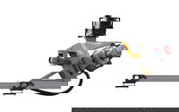
NavVis Sets New Standard in SLAM Precision
MUNICH, Germany – NavVis, a global leader in mobile indoor mapping, visualization, and navigation, announces new mapping software that significantly improves the accuracy of simultaneous localization and mapping (SLAM) technology in indoor environments, such as long corridors. The software update will be available for users of the NavVis M3 Trolley and will significantly improve the accuracy of the resulting maps and point clouds. NavVis’ mobile mapping system, the M3 Trolley, builds upon SLA...

Pettibone Introduces Next Gen T944X Telehandler With Industry-Exclusive Traversing Boom
BARAGA, Mich. — The new Pettibone Traverse T944X is the industry’s only new telehandler with an extendable, traversing boom that moves loads by traveling horizontally. Up to 70 inches of horizontal boom transfer allows users to precisely and safely place loads at full lift height through tight openings without having to coordinate multiple boom functions. With the Traverse, the specified lift height of 44 feet, 6 inches is nearly identical to the 44-foot landing height. This stands in co...
Leica Geosystems Introduces Latest in Linear Mode LiDAR
Heerbrugg, Switzerland – Leica Geosystems, industry leader in measurement technology, announced today the launch of TerrainMapper, its next generation linear mode LiDAR system. As part of the RealTerrain airborne LiDAR mapping solution, the new sensor builds on Leica Geosystems sensor technology and is supported by the HxMap unified multi-sensor post-processing workflow. TerrainMapper enables users to increase point accuracy, deliver even point density across the swath, and accommodates more...
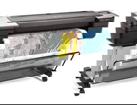
Trimble Announces New MX9 Mobile Mapping System for Surveying, Engineering and Geospatial Professionals
SUNNYVALE, Calif —Trimble (NASDAQ: TRMB) announced today the release of the Trimble® MX9 mobile mapping solution. The Trimble MX9 combines a vehicle-mounted mobile lidar system, multi-camera imaging and field software for efficient, precise and high-volume data capture for a broad range of mobile mapping applications such as road surveys, topographic mapping, 3D-modeling and asset management. The Trimble MX9 captures dense point cloud data along with 360 degree immersive georeferenced im...

Leica Geosystems Multipurpose Mobile Mapping Platform Increases Smart City Applications
Heerbrugg, Switzerland – Leica Geosystems, industry leader of measurement technology, released today the new Leica Pegasus:Two Ultimate, an upgrade to its current mobile mapping platform bringing higher quality digital reality capture to the market. Users can service new market segments, including Smart City applications by digitising road and rail infrastructures while expanding into new markets in support of autonomous vehicles, with seamless 360 and higher resolution imagery, and increas...
HP Launches the World’s Most Secure Large Format Printers for GIS mapping
PALO ALTO, Calif. — HP Inc. today introduced HP DesignJet T1700 printers, next-generation 44-inch solutions for CAD and geographic information system (GIS) workgroups to produce highly accurate documents and maps with powerful processing and a new level of security. New added features on the HP DesignJet T1700 make it the most secure large format workgroup printer available today1. The improved security is designed to help enterprises print CAD and GIS applications while protecting prin...
Stormwater Interview with Robert Page, P.E., Vice President, HNTB

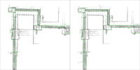
TriMet’s Banfield Type 1 Substation Replacement Project

February Issue 2026
