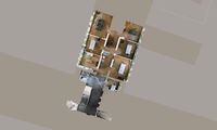
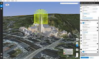
NavVis IndoorViewer 2.4: New Features Automatically Generate Highly Detailed Floorplans and Extend Routing Function
Munich, Germany – NavVis, the leading global provider of indoor spatial intelligence technology and solutions for enterprises, announces the release of NavVis IndoorViewer 2.4. This major software release includes an option to automatically generate highly detailed floorplans, enhanced routing capabilities, a new way to customize and view content and enterprise-ready security features. NavVis IndoorViewer is a web-based application that combines realistic 3D visualization of buildings with a...

Autodesk to Showcase New Unity Integration, Connected BIM at AIA 2019
Visualization and collaboration are at the heart of design, and new technologies like virtual and real-time reality, as well as cloud connectivity, have the potential to improve the way architects create and work. Tomorrow kicks off the AIA Conference on Architecture 2019, and this year Autodesk will be showcasing a new integration with Unity, as well as updates to BIM 360 Design since its debut at AIA 2018. Today, Unity announced Unity Reflect – the company’s first...

Unity Technologies Announces Unity Reflect – First of Its Kind Product Enables Real-Time BIM Collaboration on Any Device With One Click
SAN FRANCISCO - Unity Technologies (https://unity.com), creator of the world’s most widely used real-time 3D development platform, today announced Unity Reflect: a new product which will enable Architecture, Engineering and Construction (AEC) professionals to unlock the value of BIM data by putting it directly in the hands of any user and on any device. Unity Reflect makes real-time data visualization and data collaboration possible with a Revit plug-in that exports BIM and CAD data in just one...
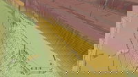
Virtual Surveyor Unveils Terrain Lenses in Drone Mapping Software
LEUVEN, Belgium – Virtual Surveyor has unveiled Terrain Lenses in Version 6.3 of its popular drone surveying and mapping software. Overlaid on a LiDAR point cloud or orthophoto, the six lenses enhance different aspects of the terrain in 3D to give users a better understanding of the topography in the area they mapped with an unmanned aerial vehicle (UAV). The Virtual Surveyor package enables professional surveyors to generate accurate topographic end products from drone data five times faster...

McCain Inc. to Unveil Transparity® TDX, at the Intelligent Transportation Society of America's Annual Meeting
VISTA, California – McCain, Inc. announced today that it will formally unveil Transparity® TDX during the Intelligent Transportation Society of America’s (ITS America) Annual Meeting in Washington, D.C., being held June 3-7. Transparity TDX (Transportation Data Exchange) will provide a new cloud-based software platform serving a network of standards compliant transportation applications and data processing services. As individual transportation systems are advancing, Transparity TDX is the answe...
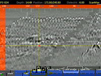
GSSI Releases Improved StructureScan™ Mini XT GPR Concrete Inspection Features with Software Update
GSSI, the world’s leading manufacturer of ground penetrating radar (GPR) equipment, announces the release of a major software update for the StructureScan™ Mini XT – the newest generation of GSSI’s popular all-in-one concrete inspection GPR system. The update expands StructureScan™ Mini XT capabilities with an increased depth range, improved Focus Mode, and a new Auto Drill feature. The update increases StructureScan™ Mini XT’s depth range by 20% to up to 24 inches for greater visibility in s...
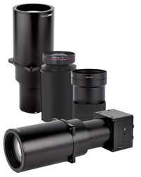
Phase One Industrial Introduces Three High Performance Lenses for High-Altitude Aerial Photography and Long-Range Aerial and Ground Inspection
COPENHAGEN – Phase One Industrial today expanded its RS and RSM lens offering with three new high performance lenses for high-altitude aerial photography and long-range aerial and ground inspection applications. The 300mm AF, 180mm, and 150mm MK II lenses are designed to enhance the performance and flexibility of Phase One Industrial’s iXM-RS and iXM aerial camera series. Each offers precision imagery, taking advantage of the cameras’ ultra-high resolution backside-illuminated (BSI) CMOS sensors...
Topcon Announces Next Generation Flight Planning Software
LIVERMORE, Calif., U.S./ CAPELLE A/D IJSSEL, the Netherlands – Topcon Positioning Group announces the next generation flight planning system for its rotary-wing aerial UAV offering — Intel® Mission Control Software. The new software is designed to facilitate automated flight planning, managing missions, and data handling for the Intel® Falcon™ 8+ Drone – Topcon®Edition and its available payload options. The software is designed to increase accuracy with advanced mapping features that allow op...

Topcon Announces Advanced Bentley Integration for Aerial Photogrammetry Processing
LIVERMORE, Calif. & CAPELLE A/D IJSSEL, Netherlands - Topcon Positioning Group announces new cloud-based photogrammetry processing powered by Bentley ContextCapture to its MAGNET Collage Web web-based service for publication, sharing, and analysis of reality capture data. The integration allows MAGNET Collage Web users who share and collaborate with scanning and mesh datasets to now process and add UAV photos directly to the MAGNET Collage 3D environment. The built-in Bentley ContextCapture C...
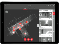
New Complete Ecosystem Created with Smallest Imaging Laser Scanner, Award-Winning Mobile-Device App
(HEERBRUGG, SWITZERLAND, 22 MAY 2019) - Leica Geosystems, part of Hexagon, today announced the Leica Cyclone FIELD 360 laser scanning mobile-device app now works in conjunction with the Leica BLK360 imaging laser scanner to create a laser scanning ecosystem where captured data is streamlined for registration and publication. With the innovative combination of laser scanner and software, users can view, quality control and prepare data directly in the field using a tablet computer. Downstream,...
Stormwater Interview with Robert Page, P.E., Vice President, HNTB

TriMet’s Banfield Type 1 Substation Replacement Project

February Issue 2026
