
ACI Certification Verify App Now Available for Download
FARMINGTON HILLS, Mich. – The American Concrete Institute (ACI) has released its new ACI Certification Verify app. The app allows users to quickly and easily verify the status of ACI-certified individuals through three search options: (1) verify an individual’s certification ID number, (2) search by an individual’s name, and (3) find the total number of ACI-certified individuals in an area. Download the app through the Apple App Store. ACI has certified more than 400,000 concrete finishers...
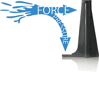
Leaving Sand Bags in the Past - Muscle Wall
Muscle Wall is a portable barrier primarily used to contain or divert water. However, our customers have found Muscle Wall to be a useful tool with many other applications as well. Some of which include: Flood Control Stormwater Management Primary & Secondary Containment Coastal Erosion & Many more... DOES IT REALLY WORK? It sure does! Muscle Wall is able to withstand the immense force of rushing or standing water due to its patented toe design. The pressure of the water...

Leica Geosystems, Autodesk Further Collaborate to Streamline Construction Documentation
(Heerbrugg, Switzerland, 26 June 2019) – Leica Geosystems, part of Hexagon, today announced further cooperation with Autodesk to offer streamlined communication and collaboration by integrating the field software Leica Captivate and iCON with Autodesk BIM 360. With the increasing complexity of construction projects and massive amounts of information generated, interoperability with various information systems and industry standards is a requirement for project success. The two organisations...
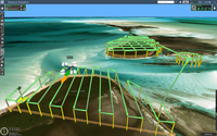
New UgCS Drone Mission Planning Software Update Arrives with Exciting Features
Riga, Latvia - June 26, 2019 - Improving core functionality, the new UgCS v.3.3 boasts a brand-new photo placemark feature and better mission saving and loading performance. For this latest update of the UgCS, its developer – SPH Engineering – has focused on improving the user experience and extending the analytics capacities of its smart drone mission planning software. Photo placemarks for a more detailed survey analysis The key new feature is the photo placemark option, allowing for...
LIDARUSA Puts Safety First With Drone Rescue Systems
LiDARUSA is pleased to announce the option of the Drone Rescue Systems parachute system with all DJI M600 UAV sales. As UAV’s become increasingly common for mapping applications the likelihood of a crash increases. The #1 concern for any pilot should be the safety of all people in the vicinity. Equipment safety is #2. Any mapping equipped drone will have enough weight to potentially harm a person even if falling from a low altitude flight. The Drone Rescue system greatly mitigates this danger...

SimActive Launches New Drone Processing Service
Montreal, Canada, June 25th, 2019 – SimActive Inc., a world-leading developer of photogrammetry software, announces a new drone data processing service based on Correlator3D™. Clients can now upload full projects and have SimActive experts generate optimal results from their imagery, including DSMs, DTMs, 3D models and orthomosaics. As opposed to common cloud-based solutions where outputs are generated automatically and delivered as-is, the new offering includes quality control by photogramm...

American Concrete Institute Releases New ACI 562-19 Repair Code
FARMINGTON HILLS, Mich. – The American Concrete Institute (ACI) announces that ACI 562-19 Code Requirements for Assessment, Repair, and Rehabilitation of Existing Concrete Structures and Commentary is now available in print and digital formats. ACI 562-19 was specifically developed to integrate with the International Code Council’s International Existing Building Code or to be adopted as a stand-alone code. ACI 562 was written specifically to be integrated into building codes as a mechanism...

EarthDefine Announces the National Building Map: A Seamless Source of Building Footprint Data
REDMOND, Wash.- EarthDefine, a provider of high resolution spatial data products, has released its National Building Map product that precisely maps over 137 million building outlines across the contiguous US. The dataset also includes accurate locations and addresses to support enhanced routing and rooftop-accurate geocoding for millions of properties across the country. The National Building Map product is powered by state-of-the-art deep neural networks. These are a class of artificial int...
PlanGrid Introduces Advanced RFIs and Project Hub to Boost Project Visibility and Extend Workflows to the Field
New products enable construction teams to resolve issues faster so they can stay on track and reduce project risk SAN RAFAEL, Calif, June 18, 2019 - Autodesk, Inc. (NASDAQ: ADSK), today announced availability of PlanGrid Advanced RFIs and Project Hub, two powerful new additions in the PlanGrid platform that give construction teams greater visibility into a project's progress and unforeseen challenges. Advanced RFIs automate the Request for Information (RFI) workflow to speed up the process, a...

Hexagon’s Geospatial Division Adds M.App Enterprise and M.App X to Education Program
Hexagon’s Geospatial Division will make its M.App Enterprise and M.App X solutions available through its global Education Program beginning 11 June 2019. This addition will offer students a chance to experience enhanced geospatial app building and deployment, giving them a technical edge in a competitive job market. “As the geospatial industry progresses into enterprise cloud-based applications, we need to equip universities with the proper tools to prepare students for the future,” said Mi...
Stormwater Interview with Robert Page, P.E., Vice President, HNTB

TriMet’s Banfield Type 1 Substation Replacement Project

February Issue 2026
