
Leica Geosystems innovates automated total station portfolio
Range of automated total stations now with new integrated functionalities increase productivity in any environment (HEERBRUGG, Switzerland ) – Leica Geosystems, part of Hexagon, has enhanced the entire automated total stations portfolio in 2020. Starting with the new Leica Nova MS60 MultiStation and TS60 total station, now the new Leica TS16 and TS13 total stations and the new TM60 monitoring total station are introduced. Leica Geosystems’ automated total stations range is designed t...

Polygon Announces PolySlide® Composite Tubing for Pneumatic and Hydraulic Cylinders
Ideal for replacing metallic material in a variety of cylinder applications Walkerton, IN – Polygon Composites Technology, a leading manufacturer of composite tubing solutions for bearings, dielectric applications, surgical devices and more, announces PolySlide® Composite Tubing for pneumatic and hydraulic cylinders. PolySlide tubing replaces metallic material in a variety of cylinder applications. Supplied as a cylinder tube ready for customer assembly, or as fully engineered cylinde...
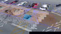
Virtual Surveyor Introduces Curb & Gutter Mapping in New Version of Drone Surveying Software
AARSCHOT, Belgium – Virtual Surveyor has introduced Curb & Gutter mapping functionality in Version 7.6 of its popular drone surveying software. The new capability enables surveyors to create a lightweight CAD model of curbs and gutters along the edges of streets and parking lots from standard orthophotos and elevation models captured by unmanned aerial vehicles (UAVs), or drones. “Accurately mapping the height of curbs and geometry of gutters is critical for modeling the flow of water away fr...

IntelliCAD Technology Consortium Announces Release of IntelliCAD® 10.0a
Portland, OR, USA — The IntelliCAD Technology Consortium (ITC) today announced the release of IntelliCAD 10.0a. IntelliCAD 10.0a is a maintenance release for version 10.0 that was previously issued on July 30, 2020. IntelliCAD maintenance releases concentrate on fixes, but IntelliCAD 10.0a includes minor new features: choose the color of print stamps, determine whether print stamps print upside down, and use the new Show Palettes and Hide Palettes commands. Also included for multiline text are...

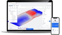
UP42 Partners with Intermap to Bring High-Resolution Elevation Data to UP42’s Geospatial Marketplace
NEXTMap Digital Surface Model (DSM) BERLIN, Germany – UP42 is pleased to announce that the NEXTMap Elevation Data Suite from Intermap Technologies is now offered on the UP42 developer platform for Earth observation data and analytics. The NEXTMap 3D elevation products are available as Digital Surface Models (DSM) and Digital Terrain Models (DTM) at one-, five-, and 10-meter resolution. The addition of NEXTMap datasets to the UP42 marketplace enables users to build even more powerful...
OnScale Introduces OnScale Solve™: The World’s First Cloud Engineering Simulation Platform
Silicon Valley, CA – OnScale today announced the release of the OnScale Solve, the web-based cloud engineering simulation platform bringing to engineers powerful multiphysics solvers and scalable cloud supercomputer resources. “OnScale Solve gives engineers, designers, and analysts access to the powerful cloud-native engineering simulation tools and cloud supercomputer resources they need to innovate, solve complex problems, and efficiently work from any location and device,” says Ian Campbel...
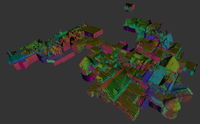
GeoSLAM Completes Spook-Tacular Scanning of Californian Landmark
The team at geospatial 3D mapping specialist GeoSLAM has produced a digital twin of one of the world’s most haunted mansions, The Winchester Mystery House, using the newly-launched ZEB Go. It may be hard to believe the feat of scanning this vast architectural landmark, built in 1886. The site, located in the City of San José, spans 4.5 acres and the four-story mansion covers 24,000 square feet, featuring some 160 rooms, as well as 40 staircases, basements and a myriad of passages, corridors a...

Datumate Announces Autodesk BIM 360 Integration for Improved Construction Site Visualization and Project Management
No-code integration empowers planning and construction teams with essential construction intelligence extracted in near real-time from survey-grade reality captures. YOKNEAM, Israel – Datumate, developer of the DatuBIM Construction Data Analytics platform, is pleased to announce today a productivity-enhancing integration with BIM 360®, a construction management software part of Autodesk Construction CloudTM. Seamless integration enables joint customers to stay informed about on-site construct...
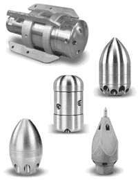
Tier 3 Nozzles Optimize Sewer Crew Efficiency and Profitability
Water conserving Tier 3 nozzles clean better and faster, enabling work crews to accomplish much more before having to refill the sewer truck water tank In sewer, storm and sanitary line cleaning, hose nozzles are an essential tool that directs pressurized water to clear out obstructions such as silt, sludge, grease, mineral buildup, and tree roots as part of required maintenance or to prepare pipes for re-lining. In this way, the nozzle is like a gun and water like bullets that must be...

GSSI Updates to StructureScan™ Mini XT GPR Kit and Palm XT Antenna
GSSI, the world’s leading manufacturer of ground penetrating radar (GPR) equipment, announces new updates to the StructureScan™ Mini XT all-in-one GPR concrete inspection system, including a software update and a newly designed survey wheel for the Palm XT Antenna. Rugged, compact, and flexible, the StructureScan Mini XT is ideal for locating rebar, conduits, post-tension cables, and voids. The Mini XT can help identify structural elements, including pan deck and concrete cover, and can also...
Stormwater Interview with Robert Page, P.E., Vice President, HNTB

TriMet’s Banfield Type 1 Substation Replacement Project

February Issue 2026
