
Q.E.D. LASER One™ Natural Gas Leak Detector Now Available in North America
Leading instrument targets methane (CH4) detection and localization of leaks Dexter, MI (DATE) – Q.E.D. Environmental Systems, Inc., a leading manufacturer of innovative environmental products and subsidiary of Graco Inc., introduces the Huberg LASER OneTM natural gas leak analyzer for sale in North America. This state-of-the-art portable natural gas leak analyzer detects methane using tunable diode laser absorption spectroscopy. This highly-sensitive detector offers all of the advant...
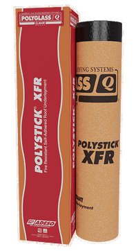
Polyglass Announces Polystick XFR Self-Adhered Fire-Resistant Roof Underlayment
Introducing Polystick XFR, a dual-purpose fire resistant and self-adhered waterproofing underlayment featuring Burn-Shield Technology™ Polyglass U.S.A., Inc., a leading manufacturer of roofing and waterproofing systems, is pleased to announce the release of Polystick XFR, an advanced dual-purpose fire-resistant and self-adhered waterproofing underlayment that provides superior fire resistance for combustible decks with metal roof coverings and other high-temperature applications. Wher...

Arcadis Gen launches two apps designed to help water companies plan and make better investment decisions
The apps help address water and wastewater pipes and above ground asset management Highlands Ranch, Colo.– Arcadis Gen, the digital business from global design and consultancy firm Arcadis, launched two new digital products today designed for the water industry. The Water Above Ground Optimizer (WAGO) and Water Artificial Intelligence Pipe Predictor (W(AI)PP) are web-based apps built to help water utilities plan and better use their data to inform investment decisions on water and wastewater...

Powerful, Real-Time Collaboration Becomes a Reality with Autodesk and NVIDIA
Autodesk and NVIDIA will demonstrate the power of real-time collaboration in design and engineering at Autodesk University this year. NVIDIA Omniverse signals a new experience for professionals in the Architecture, Engineering, and Construction (AEC), manufacturing, and media and entertainment industries. NVIDIA calls it Omniverse and we see it as an embodiment of the ‘new possible.’ NVIDIA Omniverse: Real-time, Cross-industry Collaboration Today, a major challenge is the inability of differen...
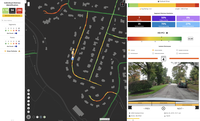
RoadBotics Debuts HD-PCI Ratings on Road Assessment Platform
PITTSBURGH, PA - RoadBotics is introducing a much-anticipated feature on its automated and objective road assessment platform, RoadWay, called HD-PCI, along with other enhancements to make pavement planning easier for its clients and partners. The official unveiling will occur during their first annual virtual User Conference scheduled for Thursday, November 12. RoadBotics has always provided its users high-definition imagery of their road network with conditional, color-coded 1-5 ratings on...

Esri Announces Launch of ArcGIS Field Maps
REDLANDS, Calif.- Esri, the global leader in location intelligence, today announced the launch of the ArcGIS Field Maps mobile app. ArcGIS Field Maps is an all-in-one app that uses data-driven maps to help mobile workers collect and edit data, find information, plus report their real-time locations. ArcGIS Field Maps will solve many workflow challenges for organizations that have prioritized digital transformation from paper-based to digital field operations management. “In the past, someone...

SimActive Releases Version 8.6 of Correlator3D™
Montreal, Canada – SimActive Inc., a world-leading developer of photogrammetry software, announces the release of Correlator3D™ version 8.6. The new version includes multiple new features, such as the use of intensity data from LAS files for image registration, the ability to improve mosaic seamlines with a DSM and the support of DJI sun sensors. The software also now allows to handle single image satellite projects. Specifically, aerial triangulation can be performed using GCPs to improve...

Pix4D launches new ground image capture app for 3D modeling with the iPad Pro and iPhone 12 Pro
Lausanne, Switzerland, [November 10, 2020]: Pix4D, the photogrammetry industry leader, announces today the release of a new app product for ground images acquisition: Pix4Dcatch. Pix4Dcatch empowers users to easily create ground-based 3D models using an iOS mobile device. No need to be an expert, the user simply scans the area of interest with Pix4Dcatch. The app records pictures along with GPS positions. Compatible with recent iOS devices, but optimized for the newest iPad Pro and iPhone 12...
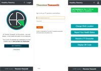
Thornton Tomasetti releases 'Healthy Reentry' free software to aid safe office return
Open Source App Provides Customizable Health Reporting And Contract Tracing Capabilities New York, NY – Thornton Tomasetti has open sourced its proprietary Healthy Reentry (HR) application for health monitoring and contract tracing. Designed to facilitate the safe return of employees to the workplace, the web-based solution can be customized to meet the needs of large and small companies while protecting the privacy of staff. Healthy Reentry enables employees to record their health s...

Enscape Releases Version 2.9 With Vectorworks 2021 Integration
Milestone release adds Vectorworks to Enscape’s list of fully supported 3D modeling programs Columbia, MD (November 5, 2020)—Enscape GmbH, the leading provider of real-time rendering and virtual reality technology for the global architecture, engineering and construction (AEC) industry, has launched Enscape 2.9. This release supports Vectorworks 2021 from global design and BIM software provider Vectorworks, Inc. and allows architects, landscape design professionals and entertainment designer...
Stormwater Interview with Robert Page, P.E., Vice President, HNTB

TriMet’s Banfield Type 1 Substation Replacement Project

February Issue 2026
