
New Leica CityMapper-2L configuration enables digital twin creation of cities in complex weather and congested flight operation areas
With a new focal length combination for ultra-high resolution projects or operations when low flying altitude is required, the Leica CityMapper-2 now offers a full product portfolio covering all flying parameters and GSD’s (HEERBRUGG, SWITZERLAND) – Leica Geosystems, part of Hexagon, introduces the new Leica CityMapper-2L configuration specifically designed for airborne urban mapping projects at low altitude operation. Lower flying heights can be required by air traffic control (ATC) restrict...
New ASCE Publication Offers Guidance on Using Remote Sensing Monitoring
Reston, Va. – ASCE’s newest publication, Remote Sensing for Monitoring Embankments, Dams, and Slopes, GSP 322, provides information on selecting and deploying a monitoring network to assess the behavior, geometry, total and differential for embankments, dams, and slopes (EDS) movement, and potential risks of the EDS movement on people and infrastructure. This Geotechnical Special Publication covers general technologies used for EDS monitoring, selection and installation of networked sensors f...
Remote GeoSystems Awarded Patent for Essential Geospatial Full Motion Video “Geo-editing” Technology
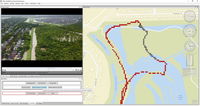
FORT COLLINS, Colorado, USA, - Remote GeoSystems, Inc., a global provider of immersive geospatial full motion video and survey data mapping software and recorder solutions, is pleased to announce the award of US Patent Number 10,893,287 on January 12, 2021 for essential elements of “video geo-editing” technology capabilities. The patent covers map-based GPS data and video segment selection, extraction and re-splicing functionality found in products like LineVision Desktop, Video GeoEditor and...

Q-Free launches first multiuse high-speed weigh-in-motion and multimodal classification solution
The versatile, future-proof HI-TRAC® TMU4X was developed in direct response to global demand for a single roadside data solution to help communities address Vision Zero and sustainability goals. NORTH SOMERSET, England, UK – Q-Free (OSE: QFR), a global leader in mobility solutions for smart city infrastructure, announced the formal launch of the HI-TRAC® TMU4X, an advanced multimodal, high-speed weigh-in-motion (WIM) and data collection solution offering automatic vehicle classification...

Autodesk Expands Preconstruction Offering with Global Launch of Autodesk Takeoff
SAN RAFAEL, Calif., March 9, 2021 — Autodesk, Inc. (NASDAQ: ADSK) today announced the worldwide availability of Autodesk Takeoff, a new product that empowers estimators to perform 2D and 3D quantification workflows from a common data environment to increase collaboration, speed and accuracy during the estimation process. Originally announced at Autodesk University in November 2020, Autodesk Takeoff will join Autodesk Build and Autodesk BIM Collaborate as part of the Autodesk Construction Cloud u...
Tensar Unveils Next Generation of the Leading Geosynthetic Design Software
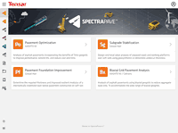
SpectraPave wins 2021 Constructech Top Products Award; launches online and mobile app (Alpharetta, GA) – For years, engineers, contractors and owners around the world have depended on Tensar’s SpectraPave software as a tool to design optimal pavement and gravel sections for a variety of subgrade support conditions. The new generation of this industry-leading software was specially redesigned to accommodate the collaborative, online needs of today’s civil and geosynthetic engineers. Spect...

Video: Reimagine Bridge Inspection with Azure Remote Rendering and HoloLens
Discover how Bentley Systems enables remote bridge inspection with Azure Remote Rendering and #Microsoft HoloLens. Learn more about Azure Remote Rendering: https://www.aka.ms/remoterendering
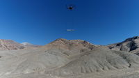
Accelerating exploration for geothermal energy with UAV magnetometry conducted in North-Central Nevada
Reno, Nevada, USA; Riga, Latvia - Geophysics faculty and graduate students from the University of Nevada, Reno, announce new exploration for blind geothermal systems with Unmanned Aerial Vehicle (UAV) magnetometry. The study site is located in the Humboldt Range, Nevada. By improving the margins of safety and ease of deployment, geophysicists can now conduct larger regional analysis for geothermal or mineralogical interests. Geothermal power is produced in many regions throughout the world a...
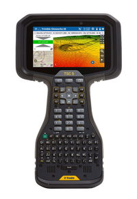
Trimble Introduces Siteworks SE Starter Edition Site Positioning Software for Construction Surveying
SUNNYVALE, Calif.—Trimble (NASDAQ:TRMB) introduced today the Trimble® Siteworks SE Starter Edition, an entry-level, easy-to-use construction surveying software at an affordable price point. Using a construction GNSS receiver, a supervisor, foreman, grade checker or site engineer can easily check a grade, slope or alignment and navigate the project more accurately and in less time than with traditional survey methods. Budget-conscious contractors can realize a quick return on investment by giving...
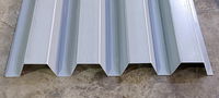
New Millennium introduces 32-inch-wide steel roof deck
Fort Wayne, INDIANA — New Millennium Building Systems today announced the addition of NW32™ steel roof deck and NW32 acoustical deck to the company’s line of award-winning roof and floor systems. At 32 inches wide, NW32 roof deck is 8 inches wider than standard N deck, enabling it to cover larger areas with fewer deck panels. NW32 steel roof deck adds another cost-efficient, high-performance option to what already is the broadest and deepest roster of structural steel building systems under...
Stormwater Interview with Robert Page, P.E., Vice President, HNTB

TriMet’s Banfield Type 1 Substation Replacement Project

February Issue 2026
