
CompassCom Releases New Features and Pricing Program to Benefit Winter Operations
DENVER, CO –CompassCom is pleased to announce the release of version 7.9 of CompassTrac® fleet and asset tracking and management solution. The features within this new release bring more detailed spreader controller information and provide further insight through enhanced dashboard and reporting functions. More specifically the features include: Integration of Force America, Bosh Rex Roth, and Certified Power Solutions Spreader Controllers for granular, pre-wet and liquid materials –...

Over 350,000 Projects Turn to Autodesk Construction Cloud for Preconstruction Workflows
Autodesk releases new product enhancements for quantity takeoff and design review workflows to increase collaboration and mitigate risk during preconstruction San Francisco, Calif. -- September 23, 2021 – Autodesk, Inc. (NASDAQ: ADSK) today announced that more than 350,000 projects across the globe are using Autodesk Construction Cloud to power more effective preconstruction workflows, including document management, bid management, quantification, model coordination and design collabora...
Applanix Introduces New Term Licenses for POSPac MMS, POSPac UAV and New Subscription for POSPac PP-RTX for UAV to Lower Upfront Costs
Customers can access the latest software releases and features with the included maintenance and support RICHMOND HILL, CANADA, Sept. 23, 2021—Applanix, a Trimble Company (NASDAQ: TRMB), announced today the introduction of new term licenses with full maintenance and support for its desktop post-processing software—POSPac™ Mobile Mapping Suite (POSPac™ MMS) and POSPac™ Unmanned Aerial Vehicles (POSPac™ UAV). In addition, a new subscription for POSPac™ PP-RTX for UAV is also available. These new...

Idrica, Orange, Huawei Tests Connection of Millions of Devices Via 5G to Remotely Read Water Consumption In Real Time
The pilot project is being conducted in conjunction with Orange, Huawei and other water industry partners in Valencia (Spain). September 22, 2021. Idrica is participating in the Spanish National 5G Plan, implemented by the public-sector company Red.es, promoted by the Ministry of Economic Affairs and Digital Transformation and co-financed by the European Regional Development Fund (ERDF). In the framework of this plan, fifteen pilot projects are being deployed in Valencia to apply the new...

New GeoSLAM Hardware and Software Revolutionises SLAM accuracy and automation
GeoSLAM launches its latest software offering Connect 2.0 at Intergeo. Connect 2.0 brings industry-leading accuracy to ZEB range of handheld scanners. The next generation SLAM algorithm, GeoSLAM Beam, powers new software. ZEB Vision, a new solution for colourisation and immersive walk throughs available for pre-orders. GeoSLAM has announced a major new update to its Connect software, bringing automatic processing to users of the ZEB range of handheld scanners. The release of Conne...

Guidebook on Airport Response to UAS Threats, Developed by Woolpert, Published by National Safe Skies Alliance
The information is designed to help airports develop planning, response and recovery protocols. DENVER (Sept. 22, 2021) — The “Airport Response to Unmanned Aircraft System (UAS) Threats” guidebook has been published by the National Safe Skies Alliance through its Program for Applied Research in Airport Security (PARAS). PARAS is funded by the Federal Aviation Administration and modeled after the Airport Cooperative Research Program of the Transportation Research Board. The guidebook was cr...

Data Science Helps Raleigh Water Avoid Digging Up The Streets
Xylem & Esri Partner to Analyze Risk on 88,000 Pipe Segments And Reduce Planning Time by 75% RYE BROOK, NY, (September 22, 2021) – Global water technology company, Xylem (NYSE:XYL), has helped the City of Raleigh Public Utilities Department (Raleigh Water) get a clearer picture of its 2,340 miles of pipes, some of which are more than 100 years old. Accurately predicting which parts of the pipe network might fail helps Raleigh Water pin-point maintenance, avoid unnecessary digs and reduce wat...
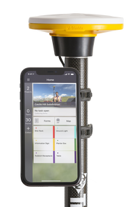
New Trimble DA2 Receiver Boosts Performance of Trimble Catalyst GNSS Positioning Service
Subscription-Based Positioning Solution with Trimble ProPoint GNSS Technology Delivers "Simply Precise" Mapping Workflows SUNNYVALE, Calif., Sept. 21, 2021—Trimble (NASDAQ: TRMB) launched today the Trimble® DA2 GNSS receiver for the Trimble Catalyst™ positioning service. The DA2—the second-generation receiver and antenna for the Catalyst service—now includes the Trimble ProPoint™ GNSS engine for enhanced performance. Unique to the latest Trimble Global Navigation Satellite System (GNSS)...

UltraCam Condor 4.1 is released
Graz, Austria • September 21, 2021: Vexcel Imaging is announcing the next camera release based on Vexcel Imaging’s 4th generation camera architecture, the UltraCam Condor 4.1. More than just a 'facelift' to the Condor M1, the UltraCam Condor 4.1 boasts multiple significant advancements to make it the gold standard for wide-area aerial mapping. The unique camera design consists of a very wide, high-resolution RGB array that delivers the utmost resolution and flying efficiency due to its impres...

InEight’s Fall 2021 Platform Innovations Double Down on Real-Time Capital Project Insights for Stronger Collaboration
Focused on bringing real-time based innovations to bear, ongoing quarterly updates will empower project teams with industry-leading capabilities — first in short-interval planning (SIP) and subcontractor management. SCOTTSDALE, Ariz. – Sept. 21, 2021 – InEight Inc., a global leader in construction project management software, today announced the rollout of the first in a series of quarterly platform enhancements designed to enable deeper project insights. These innovations will include...
Stormwater Interview with Robert Page, P.E., Vice President, HNTB

TriMet’s Banfield Type 1 Substation Replacement Project

February Issue 2026
