
WaterIQ TechnologiesTM emerges from stealth mode at WEFTEC 2021; announces three new product lines to combat harmful algae and biofilm
WaterIQ Technologies’ new Sentinel AIQTM, Pulsar 3000 and 4000TM and BioPulse 1000TM products restore and safeguard water ecosystems from harmful algae and biofilm without the use of chemicals WEFTEC, Chicago – WaterIQ Technologies, a privately owned technology company focused on developing next-generation ultrasonic solutions to combat harmful algae and biofilm without the use of chemicals, is announcing three new product lines and the availability of four new products – Sentinel AIQ, P...

Trimble and One Click LCA Collaborate to Provide Embodied Carbon Calculations for Different Phases of Construction Projects
Collaboration to Help Move the Needle Toward a Net Zero Future for Construction SUNNYVALE, Calif. and HELSINKI—Trimble (NASDAQ: TRMB) announced today that it has entered into a collaboration with One Click LCA that enables users of Trimble’s Tekla Building Information Modeling (BIM) software to calculate carbon emissions at different phases of a project, helping to move the needle toward a net zero future for construction. From early analysis and design through to finished constructi...
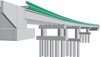
Allplan Bridge 2022: The Evolution in Modeling for Precast Girder Bridges
The new version Allplan Bridge 2022 introduces an additional specialized modeling approach that allows engineers to easily and quickly create accurate geometry for precast girder bridges. Copyright: ALLPLAN A dedicated modeling solution for generating an exact geometry easily and quickly Munich, October 8, 2021 – ALLPLAN, the global provider of BIM solutions for the AEC industry, today announced the availability of Allplan Bridge 2022. Allplan Bridge is the world’s first BIM soft...

Powerful New Advancements Strengthen Autodesk Construction Cloud
SAN FRANCISCO, Calif. — Autodesk University – Autodesk, Inc. (NASDAQ: ADSK) has announced powerful new capabilities across Autodesk Construction Cloud and an expansion of its partner ecosystem, delivering new ways for construction teams to connect their workflows on one platform. Advancements to Autodesk Build, including a new Schedule management tool, further connect office and field teams and data across the construction lifecycle. Project teams can now also integrate construction data from ov...
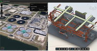
Esri Releases ArcGIS GeoBIM, Bringing Spatial Context to AEC Operations
New Product Connects with Autodesk Construction Cloud to Bridge GIS and BIM REDLANDS, Calif.—October 5, 2021—Global construction challenges, from affordable housing availability to infrastructure stress as a result of climate change, have increased in recent years. As a result, governments and commercial organizations will need to invest trillions of dollars in the next decade in mitigation and recovery processes. By adopting building information modeling (BIM) and geographic information...

Leading Design Firms Collaborate with IMAGINiT Technologies to Create New Clarity Space Programming Module
IMAGINiT Clarity 2022.1 Launches with New and Enhanced Integrations for Autodesk Revit Users BALTIMORE, MD — IMAGINiT Technologies has developed a new Space Programming Module add-on for IMAGINiT Clarity that addresses common space planning challenges that firms face on complex architectural projects. In addition to this optional, add-on module, the new 2022.1 version of IMAGINiT Clarity now includes a variety of features that enhance integrations and model metrics for Autodesk Revit and...
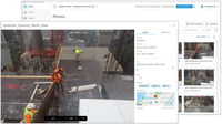
EarthCam Builds On its Connectivity with Autodesk Construction Cloud
New visual verification features for Autodesk Build Premiering new visual verification features for Autodesk Build and BIM 360 Upper Saddle River, New Jersey, Oct 5, 2021 – EarthCam, the leader in webcam technology and services, released important upgrades to its Autodesk Construction Cloud® integration today at Autodesk University. EarthCam’s live jobsite cameras can now capture and deliver imagery to Autodesk® Build, the new project management and field execution solution now availabl...
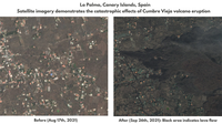
Plex-Earth 5D: Plexscape launches new platform during Autodesk University 2021 - Taking the guesswork out of civil design
Plexscape, developers of Plex-Earth, a full-blown popular platform for AutoCAD that brings the world’s largest aerial and satellite imagery providers under a single umbrella, participates again in this year’s Autodesk University as a premier sponsor. Plexscape will be officially launching Plex-Earth 5D, its latest most powerful version during Autodesk University, as it is the year’s biggest event for the Architecture, Engineering and Construction (AEC) industry. In today’s rapidly changing...

New Jobba Release Features Latest API Updates that Allow Seamless Data Flow
Jobba releases multiple new tools and feature enhancements. Chicago, IL— Jobba, the roofing industry’s leading software provider, recently added a number of new tools and features to its platform. Updates include new API connections, scheduling, estimating and accounting advancements that enhance the already robust platform. Jobba is committed to delivering what the roofing industry needs for unsurpassed data flow and management. “We are tuned into the industry and the overriding need f...

Easy Aerial Achieves AS9100 Certification for Aerospace and Defense
After months of preparation and intensive auditing, the company has satisfied all the AS9100 requirements Brooklyn, New York - Easy Aerial, a leading provider of autonomous drone-based inspection, monitoring and surveillance solutions, today announced its North America manufacturing facility has achieved AS9100 certification and registration, a standardized quality management system for the aerospace industry. The designation is the result of the company passing stringent audit requiremen...
Stormwater Interview with Robert Page, P.E., Vice President, HNTB

TriMet’s Banfield Type 1 Substation Replacement Project

February Issue 2026
