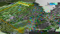
SPH Engineering and GreenValley International synchronize drone technologies for LiDAR data collection and processing
SPH Engineering and GreenValley International partner combining their expertise to deliver drone software technologies for LiDAR data collection and processing. The companies align UgCS mission planning software and LiDAR360 data processing software to optimize the workflow with LiDAR data collected with a UAV. The partnership is ready to provide a full end-to-end software toolchain for airborne LiDAR applications. It includes flight planning and data collection (done with UgCS) and data pr...

Epson Now Shipping New High-Speed, Compact SureColor T7770D 44-Inch Technical, CAD and Graphics Printer
Wide-Format Dual Roll Printer Features Innovative Design and Delivers Fastest in Class Print Speeds1 for Technical Professionals and Reprographics Providers LOS ALAMITOS, Calif. – With a space-saving design to fit into office spaces and production environments previously not possible, Epson today announced availability for the new SureColor® T7770D 44-inch dual roll printer. Featuring an innovative, compact design, the technical printer is the first available model in the new line of p...

Presagis Extends 3D Tiles Next Workflow into Esri ArcGIS Pro
The 3D Environments Add-In for ArcGIS Pro lets users convert 3D Tiles data into i3S files while preserving domain schemas, such as the One World Terrain (OWT) Ground-Warfighter Geospatial Data Model (GGDM). Montreal, Canada — Presagis, a global leader in 3D advanced modelling and simulation software, is releasing the 3D Environments Add-In application for Esri’s ArcGIS Pro. 3D Environments allows ArcGIS users to rapidly transform 3D Tiles Next data formats, such as One World Terrain, int...

How to Determine Return on Investment for Digital Delivery in Transportation
Alexa Mitchell, Transportation BIM Program Manager and Chris Williges, Economics, Director HDR Leaders Explain Research into Digital Delivery Costs and Benefits in New Experts Talk Interview OMAHA, Neb. — Digital delivery has a host of benefits in the design and construction of capital projects. But as transportation agencies grapple with competing priorities, they need to know the bottom line. Is it worth the investment? Two of HDR’s top experts led a research study to find o...

Tennessee adds Stantec’s Flood Predictor tool to support emergency management and resiliency planning statewide
Ob River Flood June 2015 Aerial View of same houses in vicinity of Nizhnevartovsk, Tyumen region, Russia. Aerial view of the residential area of the suburb of Nizhnevartovsk during the flood of 2015. The technology will allow officials to improve advanced planning efforts, helping Tennessee residents get ahead of the next major flood NASHVILLE, Tenn. (June 22, 2022) TSX, NYSE:STN The Tennessee Economic and Community Development Department (TNECD), in partnership with leading global...

Queen’s researcher develops new sensor which provides early warning of bridge damage
A new prototype sensor that provides an early warning signal if a bridge is at risk of scour – the number one cause of bridge collapse globally – has been developed by a Queen’s University Belfast researcher. Scour is erosion of riverbeds and banks, which can cause major bridge structural failure problems. Dr Myra Lydon has been working on a sensor since last year to tackle the problem. An initial prototype senor has been developed in partnership with Somni Solutions Ltd and testing has now...

Better collaboration with subcontractors, improved change order management, and new insights into project risks feature in InEight’s Innovations Update
InEight enhances capabilities of its open, integrated platform of project management solutions with a range of subcontractor management features, enhanced change-order management and insightful risk-assessment processes. Scottsdale, Ariz. June 21, 2022 – InEight Inc., a global leader in construction project management software, has today announced the latest in its program of software innovations. This round’s enhancements enable greater, real-time collaboration with subcontractors, give both...

CYPE launches the 2023 version improving BIM model accuracy and information in all project phases
The enhanced accuracy and information embedded in the digital models means that any specialist can use the company's applications to work with and integrate into a BIM project “CYPE databases have an exceptional level of detail”, Carlos Fernández, CYPE’s technical director By incorporating new codes from countries such as the UK, India, USA, Spain, Brazil, Portugal, Mexico, and Poland, CYPE is strengthening its international growth Wednesday, June 15. CYPE has launched the new 2023 vers...

New All-In-One, Cloud-Hosted Subscription Facilitates End-To-End Estimating Workflow for General and Specialty Contractors
Consistent, Reliable Data and Complementary Estimating Tools for Any Phase of the Estimating Process SUNNYVALE, Calif.—Trimble (NASDAQ: TRMB) announced today WinEst Essentials, a new cloud-hosted estimating software subscription that facilitates an end-to-end estimating workflow for general contractors and specialty contractors, such as concrete, masonry, and drywall contractors. This solution allows estimators to implement and automate their company’s estimating methodology throughout t...

Brookings Municipal Utilities Streamlines Processes, Boosts Efficiency with Modern GIS
Locana helps implement Esri ArcGIS ArcGIS Utility Network, ensures successful data migration, and optimizes results Greenwood Village, Colo. — Locana, a global leader in technology consulting and geospatial systems development, announced Brookings Municipal Utilities (BMU) successful deployment of a modern geospatial enterprise leveraging Locana services. The solution, built on the Esri ArcGIS System, including the ArcGIS Utility Network (UN), removes silos to create timely, accurate, an...
Stormwater Interview with Robert Page, P.E., Vice President, HNTB

TriMet’s Banfield Type 1 Substation Replacement Project

February Issue 2026
