
Leica Geosystems Launches New Safety Awareness Module in Leica Conx Cloud Solution
(Heerbrugg, Switzerland, August 23rd, 2022) Leica Geosystems, part of Hexagon, today announced the launch of the new safety awareness module in the cloud-based collaboration platform Leica ConX. The integration of Leica Geosystems’ safety awareness solutions with ConX increases safety on construction sites by collecting and visualising data that enhances awareness, speeds up hazard response and provides better insights. Leica Geosystems previously introduced the safety awareness solution por...
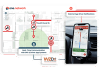
Florida DOT and one.network Launch First-of-its-Kind, Statewide Work Zone Safety Pilot Project
For the first time in the United States, construction crews in work zones will be able to post real-time lane closure information to major GPS providers. TALLAHASSEE, Florida – one.network, an innovative road management software as a service (SaaS) technology provider that empowers road agencies to plan, manage and coordinate work zones in real-time, today announced the launch of a major work zone safety pilot with the Florida Department of Transportation (FDOT). The Lane Closure Notifi...
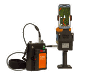
GeoSLAM adds real-time data capture feedback to ZEB Horizon
The leading handheld mobile mapping system from GeoSLAM, the ZEB Horizon, is now available with real-time feedback on data capture. The ZEB Horizon RT is compatible with most mobile devices, which attaches to the back of the handheld ZEB Horizon scanner, and generates a preview of the point cloud in real-time, ensuring complete coverage of a mapped area. The user-friendly interface gives users confidence that all areas of a scan site have been captured before finishing and leaving a jo...
Trimble RTX Integrity Validates Positioning Data Accuracy to Support Safety-Critical Applications
Providing Even More Reliable Measurements for Users of Trimble CenterPoint RTX Fast Networks in North America and Europe SUNNYVALE, Calif. —Trimble (NASDAQ: TRMB) introduced today data integrity monitoring for its precise point positioning (PPP) correction service, CenterPoint® RTX Fast. The Trimble RTX Integrity™ monitoring system is an innovative, patented solution, built in direct response to client requirements for production-ready applications. It continuously validates the reliabil...
UP42 Teams Up with Trimble for Faster Information Extraction from Geospatial Data
Automation to Enhance Feature Extraction, Change Detection on the UP42 Platform BERLIN – UP42, a leading geospatial developer platform and marketplace, is collaborating with Trimble to offer automated Trimble® eCognition® software object-based image analysis and change detection solution. The unique, object-based image analysis technology within Trimble eCognition dramatically enhances the accuracy and quality of information extracted from geospatial data. This enables eCognition developers t...
New from Oldcastle Infrastructure: Stormwater Design Tools
(Atlanta, GA) – Oldcastle Infrastructure, a CRH Company and an industry leader in infrastructure solutions, recently introduced digital stormwater Design Tools targeted at helping engineers, specifiers, regulators, and contractors design and assess stormwater management systems in an effortless and timely manner. “What makes our Design Tools different is that we offer an entire suite of solutions, all easily accessible from one dashboard,” said Craig Ramsey, director engineering, Oldcastle I...
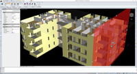
IntelliCAD Technology Consortium Announces Release of IntelliCAD 11.0
The IntelliCAD Technology Consortium (ITC) announces the release of IntelliCAD® 11.0. IntelliCAD 11.0 is a major release that includes performance improvements and new features. IntelliCAD 11.0 focuses on new view and visualization productivity tools: use section planes to visualize cross-sections of a model, view models as though you are walking or flying through them, use the view cube to check and switch viewing directions, and use the view and visual style controls to quickly appl...

WaterIQ Taps Industry Veteran Jordan Meissner to Lead Newly Established Lake and Pond Division
Experienced leader to drive growth with environmentally safe, cost-effective, simple to install ultrasonic solutions to combat the growing algae and biofilm crisis WILSON, Wyo. – WaterIQ Technologies, the leader in next-generation ultrasonic solutions to combat harmful algae and biofilm without the use of chemicals, has appointed Jordan Meissner as Vice President of the WaterIQ Lake and Pond Division. Meissner will be responsible for providing leadership and strategy – working with dealers...

CivilGEO Releases GeoHECHMS Version 1.2
Madison, WI, August 03, 2022 - CivilGEO, a leading provider of civil engineering software, today released the latest version of GeoHECHMS, a stormwater modeling software that greatly speeds up the creation, analysis, and review of stormwater models. GeoHECHMS Version 1.2 greatly simplifies the creation of storage areas (i.e., lakes and ponds), computes critical storm thresholds and allows the user to import and export HydroCAD projects. This latest release provides key new features, updates, and...
Enscape for Mac Now Shipping for SketchUp
Architects and Designers Can Now Visualize Designs in Real Time on the Mac Platform Karlsruhe, Germany – Today, Enscape announced its popular real-time rendering software used by architects and designers worldwide to turn their models into immersive 3D experiences is now available for the Mac platform. Following a successful open beta, Enscape for Mac is now shipping for SketchUp 2021 and 2022. As a direct plug-in to the modeling software, architects and designers can enjoy an integra...
Stormwater Interview with Robert Page, P.E., Vice President, HNTB

TriMet’s Banfield Type 1 Substation Replacement Project

February Issue 2026
