Bentley Systems and Topcon Collaborate for Constructioneering Academy Initiative
SINGAPORE – The Year in Infrastructure 2017 Conference – Topcon Positioning Systems, a world leader in positioning instruments for survey and construction, and Bentley Systems, a leading global provider of comprehensive software solutions for advancing infrastructure, announced today that they have joined efforts to provide opportunities for construction industry professionals to learn best practices in constructioneering, a process of managing and integrating survey, engineering, and construct...

Bentley’s New CONNECTservices Bring Comprehensive Learning, Mobility, and Collaboration Benefits to Bentley Application Subscribers
Going Digital: New Azure-based Services Accelerate Users’ Applications Mastery, and Empower Staying Connected Across Devices and Projects SINGAPORE – The Year in Infrastructure 2017 Conference – 9 October 2017 – Bentley Systems, Incorporated, a leading global provider of comprehensive software solutions for advancing infrastructure, today announced the introduction of SELECT CONNECTservices, new Azure-based services that deliver comprehensive learning, mobility, and collaboration benefits to Be...

SKUR Launches Assisted Model Alignment and Integrated Workflow to Turn Design Deviation Insights into Actions
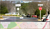
OAKLAND, California – October 5, 2017 – SKUR, the pioneer in providing as-built construction insights, today announced the launch of industry-leading innovations to make deviation detection much more streamlined and actionable. Assisted Alignment, which overcomes the need for Ground Control Points (GCPs) when aligning design and point-cloud models, and the integrated Approval Workflow, which drives accountability for deviations, are available to all SKUR customer tiers. SKUR bridges the physi...
GRM FieldForms Connects Intelligent Data Collection in the Field to the Cloud
JERSEY CITY, NJ – GRM Information Management, a leader in enterprise content management and records management, has introduced FieldForms. FieldForms is the latest advancement in GRM’s SaaS-based Intelligent Forms technology that incorporates intelligence behind distinct data fields in order to deliver higher quality and more efficient data collection. The new offline version of GRM’s cloud-based forms solution, FieldForms, delivers the same benefits without requiring internet connectivity durin...

GeoMax Releases All-In-One Office Software for Topographical Data
Widnau, SWITZERLAND: GeoMax, professional surveying and construction product provider, announced today the X-PAD Office Fusion, the all-in-one office software combining data from multiple sensors into one easy-to-use interface X-PAD Office Fusion software manages, combines and processes data from GNSS receivers, total stations, laser scanners and other sensors in one single environment whether from GeoMax or any other provider in the market. There is no need to export the data from one progra...
World First Augmented Reality Transport Intelligence Visualisation Demonstrated in Queensland
Utilising new Augmented Reality (AR) features released by Apple in iOS 11, Queensland based GPS tracking and transport intelligence company, GPSengine, has released and demonstrated the next generation in real-time data visualisation for vehicle asset tracking. Speaking at the Australian Intelligent Transport Systems Summit in Brisbane on Wednesday, CEO of GPSengine Jeremy McLean unveiled his vision of the future of data and Internet of Things (IoT) visualisation for vehicle, traffic, and ass...
Siemens Establishes Americas Digital Service Center to Help Transform Building Technologies Industry
Siemens has announced it is investing $14 million a year to establish a Digital Service Center in Austin, Texas for its Building Technologies Division that expands its capabilities to help customers collect and convert data into real-time knowledge for faster, smarter decision making. The Siemens Americas Digital Service Center is devoted to delivering solutions to help customers navigate the transformation of the building technologies industry and drive additional value of buildings via oper...
Trimble Adds Inertial-Based Trolley Solution to its Track Survey and Scanning Rail Portfolio
BERLIN — Trimble (NASDAQ: TRMB) introduced today a new addition to its track survey and scanning rail portfolio—the Trimble® GEDO IMS System. The latest trolley system is lightweight, flexible and fast. It combines an Inertial Measurement Unit (IMU) with scanning and geodetic sensors for surveying railway lines and documenting assets along the track. The announcement was made today at INTERGEO 2017, the world’s largest conference on geodesy, geoinformatics and land management. Th...

Trimble Introduces New Version of eCognition Software Suite with Powerful New Geospatial Data Analysis Capabilities
BERLIN—Trimble (NASDAQ: TRMB) today announced the release of eCognition Suite 9.3, a software platform for advanced geospatial image analysis for environmental, agriculture, forestry and infrastructure applications. Version 9.3 leverages the latest image feature extraction technology to solve challenging problems faster and more accurately for remote sensing specialists, Geographic Information System (GIS) experts, cartographers, photogrammetry and other geospatial professionals. The ann...
Trimble Expands Field-to-Finish Capabilities for Geospatial Professionals with Enhancements to Software Portfolio
BERLIN—Trimble (NASDAQ: TRMB) announced enhancements to its industry leading portfolio of geospatial office software with a new version of Trimble® Business Center and the introduction of Trimble Clarity, a new cloud-based application that enables geospatial professionals to easily visualize and share three-dimensional point cloud data with clients. The new software versions expand the field-to-finish workflows for survey and mapping professionals, providing a complete solution for the delivery...
Stormwater Interview with Robert Page, P.E., Vice President, HNTB

TriMet’s Banfield Type 1 Substation Replacement Project

February Issue 2026
