
A Digital Twin to Make Amsterdam’s 3D-Printed Steel Bridge Smarter and Safer
Amsterdam, Netherlands : Amsterdam-based startup MX3D is 3D printing a 12-meter-long stainless steel pedestrian bridge to be installed crossing one of Amsterdam’s canals in the old city center by late 2018. Today we announce that a consortium of mathematicians, IoT specialists and engineers have teamed up with us to develop a smart sensor network to monitor the bridge’s health in real time. A great example of data centric engineering. The partners joining the MX3D project include: Autode...

IDS GeoRadar Unveils Ground Penetrating Radar to Improve Safety Before Cutting or Drilling into Concrete Structures
Pisa, Italy – IDS GeoRadar, a leading provider of multi-frequency, multi-channel Ground Penetrating Radar (GPR) and interferometric technology solutions worldwide, today launched C-thrue, a radar-based technology solution specifically developed to support construction and service companies as well as civil and structural engineers to locate rebars, voids, post-tension cables, cavities, conduits and any other objects buried in the structure before cutting or drilling into the concrete. The sol...
Saudi Ministry of Interior Supports Hajj and Umrah Safety with Hexagon Safety & Infrastructure’s Intergraph Computer-Aided Dispatch Solution
Huntsville, Alabama – The Kingdom of Saudi Arabia Ministry of Interior supported the safety of pilgrims and residents during the Hajj and Umrah seasons of 2016 and 2017 by deploying Hexagon Safety & Infrastructure’s Intergraph® Computer-Aided Dispatch (I/CAD) solution. The incident management system helps the ministry’s public safety and security agencies manage emergency calls for service using a single emergency number (911). To improve security and safety for the citizens of Saudi Arabia,...

Autodesk Launches Services Marketplace Geared for the AEC Industry
By: Rachel Rosenkrantz, Strategic Program Manager at Autodesk con·nect·or kəˈnektər/ noun A thing that links two or more things together. The relationship Autodesk has with its architecture, engineering and construction industry customers is changing for the better. We spend a lot of time listening to small to medium-sized customers and hear how they often need help beyond the tech support available through Autodesk subscription. They are looking for help in the form of customiz...
Thornton Tomasetti Awarded for Innovative Technology That Greatly Advances Testing of Navy Ship Survivability
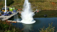
Thornton Tomasetti, the international engineering firm, today announced that the Institute of Physics, a worldwide scientific society working to advance physics for the benefit of all, has awarded the firm the prestigious Business Innovation Award for 2017. The award, presented at the Palace of Westminster in London last evening, recognizes Thornton Tomasetti Defence Ltd.’s cutting-edge airgun testing that replaces explosives testing of military vessels. Navies typically conduct powerful explosi...
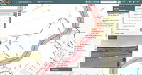
GeoDecisions Recognized for Pennsylvania Project
(Harrisburg, Pa.): The Urban and Regional Information Systems Association (URISA) recently recognized the GeoDecisions-designed Maintenance-IQ application as a Distinguished System as part of the association’s Exemplary Systems in Government (ESIG) awards.GeoDecisions developed Maintenance-IQ for the Pennsylvania Department of Transportation (PennDOT), enabling the department to use geographic information system (GIS) mapping to plan and schedule maintenance activities for the 40,000 miles of ro...
Governor Wolf Announces New Winter Travel Tool for Public, Administration Outlines Winter Preparations
Norristown, PA – With the winter season approaching, Governor Tom Wolf today announced that a new online tool is available to inform the public of Pennsylvania Department of Transportation (PennDOT) operations this winter. He made the announcement in conjunction with a news conference that PennDOT Secretary Leslie S. Richards held today outlining the agency's plans for winter services, and sharing job opportunities and driver preparation tips. "Public safety is our principal mission, which dr...
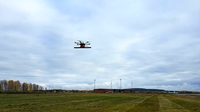
Virtual Surveyor Unveils Productivity Tools in Drone Image Analysis Software at Commercial UAV Expo
LEUVEN, Belgium, 18 October 2017 – Virtual Surveyor nv, developer of UAV image visualization and analysis software, will launch a new suite of Productivity Tools next week at the 2017 Commercial UAV Expo in Las Vegas. The Virtual Surveyor software package enables professional surveyors to generate accurate topographic end products from drone imagery five times faster than traditional field work. Virtual Surveyor will provide software demonstrations and offer discounts on new product purc...
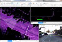
New Road-SIT Survey Vertical Application for the Maintenance of the Utility Tetworks with Mobile Mapping Technology
18 October, 2017, Bologna, Italy – Siteco announces the implementation of the Road-SIT Survey Software application, for the management of the maintenance and rehabilitation interventions of the utilities networks. The most immediate and frequent need for (public) utilities, is being able to quickly assess the cost of maintenance and rehabilitation interventions, in order to plan the required investments. Underground facility plans are usually available and rich of information such...
See Through the Surface of Ground, Ice or Any Structure with a Drone Equipped with Ground Penetrating Radar (GPR)
Riga - October 17, 2017 - To bring technically advanced solutions for surveyors, land engineers, researchers, rescue service providers and sappers - SPH Engineering - the developer of leading drone mission planning software UgCS and Radarteam Sweden AB - the manufacturer of Ground Penetrating Radars completed test flights combining Unmanned Aerial Vehicle (UAV, drone) and GPR technologies. For the test, a Radarteam Sweden AB Cobra Plug-in Ground Penetrating Radar with SE-70 antenna and p...
Stormwater Interview with Robert Page, P.E., Vice President, HNTB

TriMet’s Banfield Type 1 Substation Replacement Project

February Issue 2026
