Bentley Systems Announces Availability of OpenSite Designer
Uniquely integrates reality modeling, optimization, and automated deliverables to accelerate digital twin advancements for civil site designers EXTON, Pa. – Bentley Systems, Incorporated, the leading global provider of comprehensive software and digital twins services for advancing the design, construction, and operations of infrastructure, today announced the availability of OpenSite Designer, its integrated...
ITT Enidine Redefines Shock Absorber Industry with Sentinel™ 1
ORCHARD PARK, N.Y. – ITT Inc. (NYSE: ITT) and its Enidine brand is redefining the shock absorber industry with Sentinel™ 1, ITT Enidine’s first-generation on-board monitoring system. “Sentinel™ 1’s new patent-pending design is the first of its kind in the shock absorber industry,” said Farrokh Batliwala, Senior Vice President and President, Connect and Control Technologies, ITT Inc. “By incorporating microelectronic solutions with Enidine’s robust heavy-duty shock absorber technology, Sent...
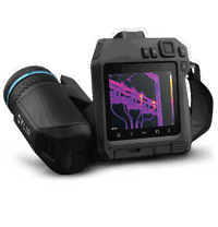
FLIR Launched Addition to High-Performance T-Series Thermal Camera Family
FLIR T840’s Integrated Color Viewfinder Simplifies Inspections Outside in Bright, Challenging Light Conditions WILSONVILLE, Ore., – FLIR Systems, Inc. (NASDAQ: FLIR) launched the FLIR T840, a new thermal camera in the high-performance T-Series family. The high-resolution T840 offers a brighter display and an integrated viewfinder to help electrical utility, plant managers, and other thermography professionals find and diagnose failing components in any lighting conditions to help avoid costl...

ASCENT Unveils 2020 Autodesk Courseware Roadmap
Industry Experts Produce Comprehensive Collection of Autodesk Software Learning Guides with Over 60 Titles to be available for Autodesk 2020 Baltimore, MD — In conjunction with the Autodesk 2020 software releases, ASCENT Center for Technical Knowledge has released its fundamental guides for the core software titles: AutoCAD, Civil 3D, Inventor and Revit. As an Autodesk Authorized Publisher, ASCENT has also published their 2020...
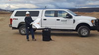
Wood Adopts Delair UX11 for Large Scale Mine Surveying and Quantity Measuring
LOS ANGELES – Delair, a leading supplier of commercial drone solutions, along with one of its regional resellers, Frontier Precision, today announced that Wood has adopted the Delair UX11 high-performance UAV for its work in site planning and asset management in mining and quarry projects in the western US. Wood - a global leader in the delivery of project, engineering and technical services to the energy, industry and built environment sectors - is initially deploying the drone to do high accu...
Video: What Is Infrastructure?
An infrastructure summary video was created by the American Society of Civil Engineers (ASCE).

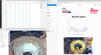
Multivista Launches 3D Images Service for Construction Industry
Phoenix, USA – Multivista, part of Hexagon, has launched 3D Images as part of its suite of documentation services for the construction industry. The service will be powered by the Leica BLK3D, which is a handheld 3D imager that allows real-time, professional grade, in-picture 3D measurement. Like its construction photo documentation service, Multivista will offer 3D Images as a full service, and support both the data capture and the data management. “Multivista enables our customers to se...

Dell Announces New, Affordable Precision Mobile Workstations
The Dell Precision 3540 and 3541 Mobile Workstations – Making Workstation-Class Performance Accessible for All Budgets From bringing cool car designs and the dragons in HBO’s Game of Thrones to life, to helping power research into the early detection of ocular diseases, Dell Precision workstations continue to help customers push the boundaries of creativity and science. Our powerhouse devices (for example: Dell Precision 7000 tower and rack workstations) are in high demand, especia...
Hexagon Introduces Monitoring Platform for Mining
PISA, Italy, and HEERBRUGG, Switzerland — Hexagon’s Geosystems division today released HxGN GeoMonitoring Hub, an integrated visualisation and analysis platform bringing all sensor technology together in one holistic view of a mining environment. The new platform uses advanced software to show highly accurate information, accelerating decision making and improving safety. HxGN GeoMonitoring Hub combines total station, GNSS, radar and other monitoring sensor data from a mining project into on...

senseFly Introduces the Solar 360 Thermal Drone Solution for Uniquely Efficient Solar Farm Inspections at AUVSI XPONENTIAL 2019
Designed to enable the automated and efficient inspection of solar farms, the new senseFly Solar 360 solution, with Raptor Maps, will be showcased on booth 2215 at AUVSI XPONENTIAL, McCormick Center, Chicago, from April 30 to May 2, 2019. Cheseaux, Switzerland, April 30 2019 – senseFly, leading provider of fixed-wing drone solutions, is introducing its new senseFly Solar 360 at this year’s AUVSI XPONENTIAL, the latest addition to its senseFly 360 solutions range. Created in collaboration with...
Stormwater Interview with Robert Page, P.E., Vice President, HNTB

TriMet’s Banfield Type 1 Substation Replacement Project

February Issue 2026
