
ITD Launches New Online Services Website for Many Division of Motor Vehicles Transactions
BOISE--Idahoans needing to renew their driver’s license, identification card or vehicle license plate can now “skip the line by going online” through a new website, Drive Idaho. “Our new online services page, Drive Idaho, brings all of the new and existing DMV’s online services into one, easy-to-navigate page,” Division of Motor Vehicles Administrator Alberto Gonzalez said. “Qualified Idahoans can now skip the line at the county sheriffs’ and assessors’ offices by going online for DMV service...
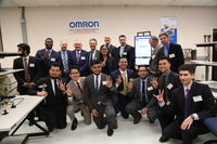
Omron Helps University of Houston Engineering Students Gain Real-World Skills with New Design and Robotics Laboratory
Omron Foundation, the charitable arm of the U.S.-based operations of industrial automation solutions provider Omron, donated a new laboratory complete with workstations and state-of-the-art equipment to give University of Houston students the opportunity to prepare for real-world engineering challenges. Hoffman Estates, IL. – The University of Houston’s Cullen College of Engineering recently unveiled a cutting-edge laboratory donated by the Omron Foundation, the charitable arm of automat...

Modulus Consulting Uses Ideate Software Solutions to Streamline Revit Workflows
San Francisco, CA – Modulus Consulting helps project teams leverage the power of building information modeling (BIM) by providing services from BIM implementation mentoring to architecture, engineering, and construction design modeling; pre-construction coordination; and construction fabrication modeling. To save time and increase the accuracy of its models, Modulus uses Ideate BIMLink, Ideate Explorer, and IdeateApps. Ideate Software developed these Autodesk Revit applications to streamline wor...
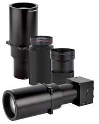
Phase One Industrial Introduces Three High Performance Lenses for High-Altitude Aerial Photography and Long-Range Aerial and Ground Inspection
COPENHAGEN – Phase One Industrial today expanded its RS and RSM lens offering with three new high performance lenses for high-altitude aerial photography and long-range aerial and ground inspection applications. The 300mm AF, 180mm, and 150mm MK II lenses are designed to enhance the performance and flexibility of Phase One Industrial’s iXM-RS and iXM aerial camera series. Each offers precision imagery, taking advantage of the cameras’ ultra-high resolution backside-illuminated (BSI) CMOS sensors...

LuxTurrim5G Ecosystem Builds the Smart City of the Future
Nokia Bell Labs driven industry group is building key enablers for fast 5G network based on smart light poles, which will form the digital backbone of future smart cities. The LuxTurrim5G ecosystem project has developed the 5G smart pole concept where 5G base stations, a variety of different sensors, video cameras, displays and other devices have been integrated to light poles. This creates a novel platform providing fast, low latency mobile communications and possibilities to exploit huge amoun...
USGS, Scientists Test Drone-Based Stream Gauging at ‘2019 Aquatic Airshow’
AUBURN, Maine — U.S. Geological Survey (USGS) and independent scientists gathered this month in Auburn, Maine, to evaluate the use of sensor-mounted unmanned aircraft systems (UAS), or drones, to gauge stream stage, velocity, bathymetry and discharge. The technology is being evaluated and modeled to determine whether it will support the fast, accurate and safe measurement of rivers, especially when they are flooded or contain floating trees, ice or other debris. Close to two dozen hydrologic,...
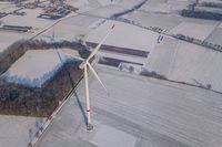
Storm gets on board with Greenbyte Energy Cloud for data management
The Belgian wind farm developer chose Greenbyte Energy Cloud for data management of their operational wind farms of 100 MW all over Belgium and Ireland. Greenbyte Energy Cloud will enable Storm to monitor and manage their wind farms, and analyze their performance for future optimization. Storm is more than the average wind farm developer. With over 400 MW in their pipeline, both in procedure and under construction, they are a rapidly growing organization. On top of that, Storm empowers custom...
Topcon Announces Next Generation Flight Planning Software
LIVERMORE, Calif., U.S./ CAPELLE A/D IJSSEL, the Netherlands – Topcon Positioning Group announces the next generation flight planning system for its rotary-wing aerial UAV offering — Intel® Mission Control Software. The new software is designed to facilitate automated flight planning, managing missions, and data handling for the Intel® Falcon™ 8+ Drone – Topcon®Edition and its available payload options. The software is designed to increase accuracy with advanced mapping features that allow op...

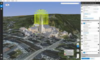
Topcon Announces Advanced Bentley Integration for Aerial Photogrammetry Processing
LIVERMORE, Calif. & CAPELLE A/D IJSSEL, Netherlands - Topcon Positioning Group announces new cloud-based photogrammetry processing powered by Bentley ContextCapture to its MAGNET Collage Web web-based service for publication, sharing, and analysis of reality capture data. The integration allows MAGNET Collage Web users who share and collaborate with scanning and mesh datasets to now process and add UAV photos directly to the MAGNET Collage 3D environment. The built-in Bentley ContextCapture C...
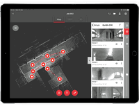
New Complete Ecosystem Created with Smallest Imaging Laser Scanner, Award-Winning Mobile-Device App
(HEERBRUGG, SWITZERLAND, 22 MAY 2019) - Leica Geosystems, part of Hexagon, today announced the Leica Cyclone FIELD 360 laser scanning mobile-device app now works in conjunction with the Leica BLK360 imaging laser scanner to create a laser scanning ecosystem where captured data is streamlined for registration and publication. With the innovative combination of laser scanner and software, users can view, quality control and prepare data directly in the field using a tablet computer. Downstream,...
Stormwater Interview with Robert Page, P.E., Vice President, HNTB

TriMet’s Banfield Type 1 Substation Replacement Project

February Issue 2026
