Cynash Announces Commercial Availability of New Cynalytic™ Analytics Platform for Industrial Control Systems Security
McLean, VA — Cynash Inc., a leading developer of industrial control system (ICS) cybersecurity solutions for critical energy, water and transportation, announces the commercial availability of its Cynalytic™ analytics appliance for serial communications-based ICS/SCADA control networks. The combination of Cynalytic and Cynash’s SerialTap™ sensors brings new visibility and analysis to serial communications—shedding light on ICS cyber blindspots and helping to reduce the risk of cyber-physical dam...
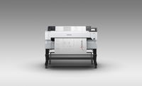
Epson Introduces SureColor T5470M 36-Inch Printer and Integrated Scanner for Enhanced Collaboration and Workflow
SAN DIEGO (ESRI, Epson Booth #327) – Epson today announced the SureColor® T5470M – a new 36-inch printer and integrated scanner offering a fast multifunction solution for printing, sharing and saving technical documents. The new model joins the Epson SureColor T-Series line of wide-format printers, and the sleek print/copy/scan combo produces accurate A1/D-size prints in as fast as 22 seconds,1 making it an ideal choice for managing blueprints, charts, posters, and more. “Epson is committed t...
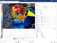
FLIR Announces Thermal Studio Software for Thermographers to Automate Thermal Image Processing
Advanced Batch Video and Image Processing Streamlines Workflows and is Available as Free Trial ARLINGTON, Va., – FLIR Systems, Inc. (NASDAQ: FLIR) introduces FLIR Thermal Studio, a thermal image analysis and reporting software designed to manage large sets of thermal images and videos. Engineered for thermographers who use FLIR thermal handheld cameras, optical gas imaging (OGI) cameras, and unmanned aircraft systems (UAS) with thermal cameras, FLIR Thermal Studio’s advanced processing capa...
“Get There” Offers Easy Ride Matching and Trip Planning to Reduce Driving Alone
SALEM — Want to reduce the cost of your drive? It’s easier than ever to share the ride with ODOT’s new carpooling tool, Get There. A web-based tool, Get There helps Oregonians plan trips, share rides with single trips or on a regular basis, and more. Get There replaces Drive Less Connect, the state’s former carpool matching tool. By typing in a starting point and a destination, users can see options for both passengers and drivers looking to share rides. Using the tool helps travelers share the...
ERM Advanced Telematics Enters the IoT market and Introduces New Sensing Solutions Designed to Monitor and Track Assets
International automotive technology supplier ERM Advanced Telematics, whose products are installed in more than 5 million vehicles worldwide, is expanding its activities from telematics solutions for locating and tracking vehicles, drivers and passengers, to a complimentary field of IoT (Internet of Things). The company is introducing its IoTLink line of products, which is based on technology that was specifically developed at ERM. The new sensing solutions use sensors and gateways that enab...

Hexagon Strengthens 3D Visualisation Capabilities with the Acquisition of Melown Technologies
ZUG, Switzerland (1 July 2019) — Hexagon’s Geosystems division today announced the acquisition of Melown Technologies, a Prague-based technology company from Ivo Lukačovič´s investment company Helifreak Limited. Melown Technologies develops mass-scale computer vision and advanced visualisation technology for interactive web-based rendering, enabling high performing 3D visualisation of digital urban and natural landscape models that are derived from aerial and terrestrial reality capture sen...
Viametris is Launching the Second-Generation Version of the vMS3D, its Urban and Road Scanner
More design-orientated and compact, this second generation version of the 3D mobile vehicle scanner has been fully redesigned. The system has been simplified considerably in both electronic and ergonomic terms to make it more robust and stable in adverse conditions and challenging environments. Despite being lighter, the second generation offers all the same technological capacities as its predecessor, but is simpler to use and can be mounted on a vehicle in just minutes. A complete new design...

Video: DDOT Begins Work On $500M DC PLUG Project
The DC Power Line Undergrounding initiative (DC PLUG) is a partnership between the District and Pepco to improve the reliability and resiliency of the District of Columbia energy grid by placing select feeders underground in Wards 3, 4, 5, 7, and 8. The DC PLUG initiative has a long history, dating back to 2012, when D.C. Mayor Vincent Gray established the Mayor’s Power Line Undergrounding Task Force (Task Force) following severe storms that caused days-long outages for portions of the Distri...
sensemetrics and DHI Partner to Offer Integrated IIoT Solutions for Mine Water Operations
SAN DIEGO - sensemetrics Inc., the Industrial IoT (IIoT) company transforming sensor data into real-time business intelligence to enable productivity and safety solutions, has entered into a partnership agreement with DHI A/S under sensemetrics’ Alliance Member Program. Under the agreement, DHI will integrate with the sensemetrics platform to automate data collection into its MIKE Mine software. MIKE Mine is DHI’s state-of-the-art operational software for water management at mine sites. Toge...
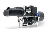
GeoCue Introduces True View, The Industry's First Drone LIDAR/Imagery Fusion Sensor
Nashville, TN – GeoCue Group Inc. unveiled its new True View™ line of drone sensors at an invitation only industry event on June 25th in Nashville, Tennessee. True View sensors offer surveyors an innovative lidar + dual oblique mapping camera configuration integrated in a single lightweight payload for use on commercial drone platforms. True View allows for fast, easy automated generation of true 3D colorized point clouds, oblique imagery and orthophotos from a single flight. In addition to...
Stormwater Interview with Robert Page, P.E., Vice President, HNTB

TriMet’s Banfield Type 1 Substation Replacement Project

February Issue 2026
