
Ideate Software eLearning Assets now Available in Pinnacle Series by Eagle Point Software
San Francisco, CA – Ideate Software, a veteran Autodesk Developer Network member, announced that its Revit workflow and training content is now available to users of Eagle Point Software’s Pinnacle Series. Pinnacle Series is a platform designed to help maximize the productivity and performance of architects, engineers, construction (AEC) and manufacturing professionals around the globe. It allows users to take full advantage of their technology solutions by allowing and enhancing continuous l...
Leica Geosystems Introduces New Generation of Manual Construction Total Stations
The new Leica iCON manual total stations digitalise measurement methods with simplified workflows (Heerbrugg, Switzerland, 18 July 2019) – Leica Geosystems, part of Hexagon, announced today the next generation of iCON manual total stations, the Leica iCON iCB50 and iCB70. The next generation of Leica iCON manual total stations further propels the industry to move from traditional analogue layout methods to digitalised construction layout techniques. Now integrated with the well-established...
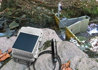
New HOBO® MicroRX Water Level Station from Onset Enables Simple, Cost-Effective Monitoring of Stormwater, Floodwater, Irrigation, and Other Water Systems
MicroRX Water Level Station provides immediate visibility into water level and flow data via 4G cellular technology and cloud-based software BOURNE, MA, July 18, 2019—Minutes can make the difference when it comes to mitigating the effects of floodwaters, stormwater, and even compromised irrigation systems. For the delivery of near real-time water level and flow alerts, Onset, a world leader in data loggers and weather stations, today announced the launch of the new cellular, web-enabled...
Trimble 4D Control Software Delivers Streamlined Real-Time Monitoring System Deployment and Simplified Geotechnical Sensor Support
Increased Capabilities Save Days of Setup Time for Real-Time Structural Monitoring Projects SUNNYVALE, Calif., — Trimble (NASDAQ: TRMB) introduced today the latest version of its core real-time monitoring software—Trimble® 4D Control software. Version 5.0 provides new features that enable users to streamline real-time structural monitoring system deployment as well as simplify the connection to geotechnical sensors. Trimble 4D Control software enables project stakeholders to monitor crit...

Geographers of the Lomonosov Moscow State University published the web-atlas of the available wave energy in the Russian seas
Wave energy distribution in the Black Sea(above) Scientists from Lomonosov MSU (Faculty of Geography) have published the first version of the Russian wave energy web-atlas. The test version of the web-atlas posted at http://autolab.geogr.msu.ru/wavenergy in open access. It contains data on the wave energy spatial distribution in the Black, Caspian, Baltic, Barents and the Kara seas. The atlas also contains information on the basic parameters of wind waves. Scientists started developin...

Vexcel Imaging Releases Subscription Image Service Solutions to Government Agencies
Boulder, CO - Vexcel Imaging today introduces its high quality and up-to-date aerial image subscription for government agencies. The cloud-based image solution, now available via subscription service, saves state and local government a significant amount of time and money by making it fast and simple to acquire up-to-date, concise, ultra high-resolution imagery and leverage it organization-wide into critical location intelligence. “Government agencies face many challenges like supporting Sma...

Terra Drone Eyes Middle East Market with New Joint Venture to Provide UAV Solutions for Survey Activities
Terra Drone sets up joint venture with NDTCCS, the largest NDT inspection services provider in the Middle East Dammam, Kingdom of Saudi Arabia – One of the largest providers of industrial drone solutions in the world, Tokyo-headquartered Terra Drone Corporation, has entered into an investment agreement with NDT Corrosion Control Services Co. (NDTCCS), a leading Saudi company which has been providing nondestructive testing and inspection services in the Middle East since 1975. With this agreem...

BQE Software Launches Industry’s First Conversational Artificial Intelligence Feature
ACCOUNTING AND PROJECT MANAGEMENT SOFTWARE PROVIDER PUSHES INNOVATION WITH RELEASE OF CORE INTELLIGENCE FOR IMMEDIATE RELEASE Torrance, CA – July 10, 2019 — BQE Software, Inc., a global leader in accounting and project management software for professional services firms, launched Core Intelligence, an Artificial Intelligence tool that allows users to have human-like conversations with their business software to gain actionable insights about their company and perform work-related tasks. B...

LIDARUSA Announces Long Endurance Multicopter LIDAR Solution
LiDARUSA is pleased to announce the integration of their UAV-scanning systems with the Harris Aerial H4/H6 Hybrid multicopters. As surveyors and mappers experience growth they assume larger and larger projects making longer flight times increasingly important. The extended flight times become increasingly important. The Harris Hybrid can provide such flights with lidar and industrial grade cameras allowing for far greater coverage in a single flight. “The beauty of the Harris Hybrid, is th...

Woolpert First Provider Approved by PennDOT to Operate Drones for State Projects
The Pennsylvania Department of Transportation requires UAS operators to undergo extensive PennDOT training in addition to attaining the FAA’s Part 107 Remote Pilot Certificate. HARRISBURG, Pa. — Woolpert had numerous surveying, mapping and geospatial professionals complete the Pennsylvania Department of Transportation’s (PennDOT) Unmanned Aircraft System (UAS) training July 2. The training is part of PennDOT’s certification process, along with attaining a Part 107 Remote Pilot Certificate thr...
Stormwater Interview with Robert Page, P.E., Vice President, HNTB

TriMet’s Banfield Type 1 Substation Replacement Project

February Issue 2026
