Autodesk Ushers in New Era of Connected Construction with Autodesk Construction Cloud
Las Vegas, Autodesk University – November 18, 2019 – Today at Connect & Construct Summit, Autodesk, Inc. (Nasdaq: ADSK) unveiled Autodesk Construction Cloud™, which combines advanced technology, a unique builders network and predictive insights to connect people and data across the entire building lifecycle, from design through operations. At the center of Autodesk Construction Cloud are best-of-breed construction solutions Assemble, BuildingConnected, BIM 360 and PlanGrid. Autodesk Construct...

Leica Geosystems Enables a New Era for GIS Data Capture
Heerbrugg, Switzerland – Leica Geosystems, part of Hexagon, announced today the Leica Zeno Mobile data collection app now integrates HxGN SmartNet post-processing service and Esri’s Geospatial Cloud, a leading provider of Geographic Information Systems (GIS). The new functionalities allow workforces with limited surveying knowledge to optimise data accuracy and precision in the field and office and enable a seamless data flow to Esri’s GIS products. Thanks to HxGN SmartNet, Zeno delivers hig...
Unreal Engine 4.24 to Ship with Free Quixel Megascans, Unreal Studio Features, and More
Quixel, creator of the world’s largest photogrammetry 2D and 3D asset library, has joined the Epic Games family, and we’re making the entire Quixel Megascans library of more than 10,000 high-quality, production-ready assets free for all use with Unreal Engine! To get you started right away, 10 new high-resolution packs, as well as the popular Iceland collection of assets used in the “Rebirth” cinematic short, are now available for free on the Unreal Engine Marketplace. The remaind...

Forney LP Launches New Website to Advance ForneyVault®
Pittsburgh, PA: Forney LP, the premier supplier of construction material testing equipment, recently advanced its newest innovation, the ForneyVault® software platform, with a new website (https://forneyvault.com/) and new logo. ForneyVault is a cloud-based construction material testing software platform that closes the loop between sample creation, testing, and data collection, dissemination and use. With ForneyVault, data flows seamlessly throughout the process, reducing the risk of errors,...

Eagle Point Software’s Pinnacle Series Launches Construction Tech Training Content Combined with Their Award-Winning Platform, to be Unveiled at Autodesk University Next Week
DUBUQUE, IA — Today, Eagle Point Software Corporation announced that they have added Construction content and training solutions for three popular software titles: PlanGrid, Assemble and BuildingConnected. This will complement Pinnacle Series’ robust content library which already includes BIM 360, Revit, Navisworks and more. Eagle Point Software is a global software company that has found its niche helping Architects, Engineers and Construction organizations create efficiencies and profitability...

10-year Anniversary of Ideate BIMLink for Revit Brings Major Enhancements
San Francisco, CA – Ideate Software, a veteran Autodesk Developer Network member, announced enhancements to Ideate BIMLink, its Revit productivity application that simplifies model management by facilitating the movement of data from Autodesk® Revit® software to Microsoft Excel for editing, and then back into Revit with speed, ease and accuracy. “As we celebrate the 10-year anniversary of Ideate BIMLink, we enjoy looking back at the meaningful enhancements added with every release,” said Glyn...
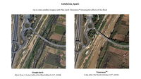
Plex.Earth Timeviews™ empowers AEC professionals with the latest satellite imagery within AutoCAD
Plexscape, developers of Plex.Earth®, one of the most popular tools for AutoCAD for the acceleration of architectural, engineering and construction (AEC) projects, launched Timeviews™, a unique service in the global AEC market, which makes the most up-to-date satellite imagery affordable and easily accessible within AutoCAD. Following a strategic partnership with Bird.i, a company that combines the latest satellite imagery and artificial intelligence to provide valuable insights, Plex.Earth...
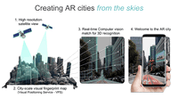
Sturfee Rolls out World’s First AR Cloud Technology for Cities that Uses Satellite Imagery to Create Magical City Experiences
Sturfee’s disruptive approach makes your smartphone cameras recognize streets using AI and Satellgery; major Japanese telco KDDI is already incorporating the production-ready tech for 5G services Milpitas, Calif. – Sturfee, a computer vision/AI solutions company, today emerges from stealth with the launch of its City AR technology, which uses satellite imagery and a mobile device to visually recognize the streets around you and digitally enhance them for applications ranging from navigation,...
Trimble Clarity Now Offered as Web Application for Point Clouds and 3D Models
SUNNYVALE, Calif.— Trimble (NASDAQ: TRMB) announced today that Trimble® Clarity is available as a stand-alone web application that simplifies the visualization and navigation of 3D data. With this major update, Trimble Clarity enables geospatial professionals to view, use and share 3D point cloud data, models and meshes with engineers, architects, city planners and other project stakeholders via a web browser, which can be viewed on desktop and mobile devices. The Trimble Clarity web applicat...
Trimble Announces Availability of the XR10 with HoloLens 2, a Next-Generation Mixed-Reality Solution for Front-Line Workers in Safety-Controlled Environments
DÜSSELDORF, Germany, Nov. 8, 2019—Trimble (NASDAQ: TRMB) announced today that it is now taking orders for the Trimble® XR10 with HoloLens 2 system, a worksite-ready mixed-reality solution that enables workers to visualize 3D data on project sites for easier and more efficient planning, collaboration and reporting. The announcement was made at A+A 2019, the largest international trade forum for safety, security and health at work. The new solution is enabled by two central components:...
Stormwater Interview with Robert Page, P.E., Vice President, HNTB

TriMet’s Banfield Type 1 Substation Replacement Project

February Issue 2026
