
PennDOT Earns Regional America's Transportation Awards for Operations Excellence and Best Use of Technology
Harrisburg, PA – The Pennsylvania Department of Transportation (PennDOT) recently received regional America's Transportation Awards for operational excellence and best use of technology. The department's operational excellence award was for the Automated Work Zone Speed Enforcement ProgramOpens In A New Window and the best use of technology award was for the Shaler Street Bridge ReplacementOpens In A New Window. "Innovation is at the heart of PennDOT initiatives across the state," said Pen...

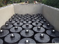
Xylem’s revolutionary Leopold Type 360 underdrain features innovative backwashing capability
New bolt down model increases efficiency RYE BROOK, N.Y., – Xylem now offers the Leopold Type 360 underdrain, a bolt down underdrain system for greenfield projects and water treatment filtration rehabilitation projects. The underdrain system has an innovative design concept where backwash water flows in a 360-degree pattern, increasing efficiency by up to 20%. “The industry challenged us to create an underdrain that combines efficiency, straightforward installation and individually se...

GNSS RTK rover with Visual Positioning increases safety, simplifies surveying
New GS18 I GNSS RTK rover with Visual Positioning can measure what you see (HEERBRUGG, SWITZERLAND, 18, August 2020) – Leica Geosystems, part of Hexagon, unveils the Leica GS18 I (announced by Hexagon yesterday), a versatile, GNSS RTK rover with Visual Positioning. The GS18 I allows users to capture points of interest from a distance and measure points from the images in the field or the office. Visual Positioning technology (sensor fusion combining GNSS, IMU and a camera) allows user...

Milwaukee Tool Integrates One-Key™ with Autodesk BIM 360®
MILWAUKEE, WI - Milwaukee Tool is proud to announce that their One-Key™ digital platform now integrates with Autodesk Construction Cloud™’s BIM 360® construction management software, enabling customers to seamlessly share information between the two solutions and enhance asset tracking, project management, and reporting. As the industry’s largest and most robust asset management platform and tracking network, One-Key™ incorporates industry-leading tool electronics with a custom-built, cloud-b...

Q.E.D. MicroPurge MP25 Simplifies Low-Flow Groundwater Sampling
Purge stabilization flow cell ensures accuracy and consistency Dexter, MI – Q.E.D. Environmental Systems, Inc., a leading manufacturer of innovative environmental products and subsidiary of Graco Inc., highlights that its MicroPurgeÒ MP25 Purge Stabilization Flow Cell system makes consistent low-flow groundwater sampling easy and accurate. The associated PurgeScanÔ technology monitors purging parameters and performs stabilization automatically, reducing potential for error and inaccuraci...

Geo-localized data collection now made easy with new OnPOZ Collect app for Android
Effigis is proud to announce the worldwide launch of its new OnPOZ Collect and Cloud solution, for efficient geo-localized fieldwork data collection and management. OnPOZ Collect is a powerful GIS mapping app that transforms a phone or tablet into a geospatial data collection tool. You will be ready for the field, whether you are completing an inventory assessment, infrastructure inspections, damage reporting, forestry projects or a variety of other project types. OnPOZ Collect is intuitive a...
Contech® Stormwater Management StormFilter® Achieves ISO 14034 Environmental Technology Verification (ETV)
West Chester, OH – Contech® Engineered Solutions announced today that the Stormwater Management StormFilter® has been verified in accordance with ISO 14034 Environmental Management - Environmental Technology Verification (ETV). Data from both laboratory and third-party field monitoring studies provided the basis for the StormFilter performance claims. ISO 14034 ETV is an international standard developed with Canadian participation that provides a protocol for third-party verification of tech...
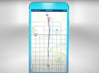
Video: Arizona DOT Launches App, Including Public Access to Traffic Cams
Arizona Department of Transportation (ADOT) released this video explaining the features of its now AZ511 app. The travel planner is able to access real-time data from the DOT, has a mode for safe dashboard mounting, and even allows users to access live feeds from traffic cameras.
New MapleMBSE release from Maplesoft expands support to include Capella
MapleMBSE 2020.2 offers expanded toolchain connectivity, improved performance and usability Waterloo, Canada: Maplesoft™ today announced a new release of MapleMBSE, the software that enables companies to implement Model-Based Systems Engineering (MBSE) processes without requiring every stakeholder on the project to be an expert in complex MBSE tools. The release of MapleMBSE 2020.2 now supports the MBSE platform Capella, in addition to improved performance and usability. MapleMBSE provides...

Enhanced geology and mine design in Vulcan 2020
Desktop tools that enable mining professionals to interact with their data are the building blocks upon which Maptek innovation was founded. Almost 40 years on from the early borehole modelling tools, Maptek has this week released Vulcan 2020, featuring integrated geology and optimised mine design. Today Vulcan is populated with functionality that provides holistic benefits to modern mining operations. These translate into increased productivity for specific applications - such as geological...
Stormwater Interview with Robert Page, P.E., Vice President, HNTB

TriMet’s Banfield Type 1 Substation Replacement Project

February Issue 2026
