
Q-Free Launches New Website with Customer-Focused View to Solve Modern Traffic Mobility Challenges
Company creates new user experience focused on holistic solutions for smarter, safer, more sustainable transportation. OSLO, Norway – Q-Free (OSE: QFR), a global leader in mobility solutions for smart city infrastructure, today announced the launch of a new website to provide a more holistic, integrated and easy-to-understand customer experience that reflects the company’s overall global mission of solving modern traffic mobility challenges and delivering innovative smart city solutions. T...

Tennessee DOT Selects Woolpert for Statewide Photogrammetry and Mapping Services Contract
The firm will provide on-call geospatial services for the design and construction of state roadways. NASHVILLE, Tenn. — Woolpert has been selected by the Tennessee Department of Transportation (TDOT) to provide on-call photogrammetric and mapping services to support the design and construction of roadways throughout the state. The three-year contract has a ceiling of $5 million. Woolpert Geospatial Program Director Sam Moffat said the firm will provide orthoimagery and lidar, digital terr...

HDR Developing Actionable Plan for Increasing Electric Vehicle Readiness in Steamboat Springs
OMAHA, Neb. — The City of Steamboat Springs, Colorado, has hired HDR to develop an Electric Vehicle Readiness Plan. The purpose of the plan is to encourage EV adoption by citizens and fleet operators by identifying barriers and developing actions items to remove them. The ultimate goal is to reduce greenhouse gas emissions. HDR’s team brings deep experience with emerging technology, zero emissions vehicles and strategic communications. Adoption of electric vehicles requires consideration o...
Applanix Introduces Next Generation OEM Solution for Direct Georeferencing of Airborne Sensor Data
Hardware and Software Solution Provides Unparalleled Accuracy and Performance for Systems Integrators RICHMOND HILL, CANADA — Applanix, a Trimble Company (NASDAQ: TRMB), introduced today the Trimble® AP+ Air OEM solution for Direct Georeferencing of airborne sensor data. The solution enables users to accurately and efficiently produce maps and 3D models without the use of ground control points. The Trimble AP+ Air is a powerful solution for manned platforms yet small enough for use on Unmanned...

Hexagon Selected for Innovate UK Rail Infrastructure Artificial Intelligence Project
Project will automate railway structure identification and measurement for Network Rail (Norcross, GA. USA) Innovate UK, the country’s innovation agency, has selected Hexagon’s Geospatial division to conduct a research project that will result in faster and higher-precision mapping of railway infrastructure through the use of artificial intelligence. The project is funded by Network Rail, the owner and operator of Great Britain’s railway infrastructure, under its R&D portfolio and delivered by...
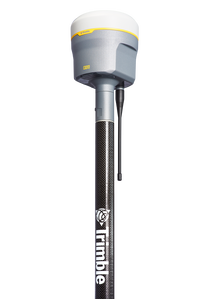
Trimble Announces the Next Evolution of its Flagship GNSS Solution
Trimble R12i GNSS Receiver Incorporates Robust Tilt Compensation to Increase Productivity for Land Surveyors SUNNYVALE, Calif.—Trimble (NASDAQ: TRMB) introduced today the Trimble® R12i GNSS receiver, the latest addition to its Global Navigation Satellite System (GNSS) portfolio. The Trimble R12i incorporates Inertial Measurement Unit (IMU)-based tilt compensation using Trimble TIP™ technology, which enables points to be measured or staked out while the survey rod is tilted, empowering land s...

Bentley Institute Press Announces Availability of Infrastructure Digital Twins: A Leadership Short Course – Volume 1: Getting to Know iTwins
EXTON, Pa. – Bentley Institute Press, publisher of cutting-edge textbooks and professional reference works for the advancement of the engineering, architectural, construction, operations, geospatial, and educational communities, has announced the availability of a new publication titled Infrastructure Digital Twins: A Leadership Short Course – Volume 1: Getting to Know iTwins, now available in print at www.bentley.com/Books, and as an e-book at www.bentley.com/Books, Amazon Kindle, and Apple Boo...

Elevate your performance with UltraMap 5.0
Graz, Austria: Vexcel Imaging announces the release of UltraMap version 5.0, the latest update of its all-in-one aerial photogrammetry software featuring comprehensive DTM generation and full integration of Ortho Production in UltraMap Studio. With the introduction of a completely new Digital Terrain Model (DTM) algorithm based on automatic semantic image segmentation and intelligent filtering, UltraMap 5.0 now generates comprehensive DSMs and DTMs for export at unprecedented quality. Additi...

Eos Positioning Systems announces compatibility of Eos Laser Mapping™ and Eos Locate™ with Esri ArcGIS Field Maps (beta)
The August 2020 release of Eos Tools Pro version 1.89 makes Eos Locate™ for ArcGIS (underground mapping) and Eos Laser Mapping immediately available for use with the Field Maps beta AUGUST 2020, MONTREAL, CANADA — Eos Positioning Systems (Eos), the Canadian manufacturer of the popular high-accuracy Arrow Series® GNSS receivers, has announced today the compatibility of two popular Eos field data-collection solutions with the Esri ArcGIS Field Maps beta. Eos Locate™ for ArcGIS is the world’s f...

The PV software archelios™ Pro Silver: manage projects up to 100 kWp
Trace Software International is excited to announce the launch of the newest editions of archelios™ Pro. The software is an excellent tool for the feasibility and bankability study, simulation, 3D design, and sizing of any photovoltaic project. As the solar market becomes more and more complex and challenging, the company has launched a new PV software offering. Trace Software International has used its expertise to create four different PV tools’ proposals, archelios™ Pro Free, archelios™ Pr...
Stormwater Interview with Robert Page, P.E., Vice President, HNTB

TriMet’s Banfield Type 1 Substation Replacement Project

February Issue 2026
