Trimble Introduces Next Generation High-Accuracy Mapping Solution for GIS Field Applications
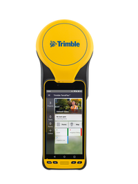
SUNNYVALE, Calif.— Trimble (NASDAQ: TRMB) announced today a new high-performance data collector for its Mapping and Geographic Information Systems (GIS) portfolio—the Trimble® TDC650 handheld. Built for GIS data collection, inspection and asset management activities, the TDC650 provides users a rugged solution with scalable high-accuracy Global Navigation Satellite System (GNSS) positioning for professional field workflows. The TDC650 is fully integrated with today’s demanding GIS data envir...

PERI Formwork Systems, Inc. Announces VARIOKIT Pier System To Revolutionize Bridge Construction
Innovative VARIOKIT Pier System Bridges Safety and Efficiency ELKRIDGE, MD (July 12, 2022) – PERI Formwork Systems, Inc., one of the leading manufacturers and suppliers of formwork and scaffolding systems for today’s construction environment, is setting a new industry standard for bridge construction with the introduction of the company’s VARIOKIT Pier System (VPS). VPS bridges the gap between safety and efficiency to provide a versatile, rentable, and high-performing system for the smar...

Ideate Software Applications Aligned with Autodesk Revit 2023 and Deliver Significant Improvements for Revit Versions 2020-2022
San Francisco, CA – Ideate Software, an Autodesk® AEC Industry Partner and Autodesk® Authorized Developer, announced enhancements to its Revit plugin applications. In addition to aligning its software with Revit 2023, Ideate Software made significant improvements that will help Revit users deliver high-quality models in less time. Perform Time-Intensive Tasks in the Background with Ideate Automation 2.0 “One of the most significant changes made is the release of Ideate Automation 2.0, a sc...

IDS GeoRadar launches Stream DP with new Equalised scrambled Technology (EsT)
Stream DP is the new compact GPR array solution introducing the ground-breaking EsT technology that brings GPR performance to the next level: the deepest one yet. PISA, Italy (12 July 2022) — IDS GeoRadar, part of Hexagon, today announced the launch of Stream DP, an innovation for 3D utility mapping that uses multi-channel ground penetrating radar (GPR). Stream DP with the patented EsT technology enables efficient and safe performance in underground utility detection and mapping. EsT equalises...

CivilGEO’s GeoHECRAS is a 2022 Industry Leader with Top G2 Software Rankings
Widely recognized business solutions ratings platform, G2, has placed CivilGEO’s GeoHECRAS as its Summer 2022 Top Performer in the category of Best Civil Engineering Design Software. Basing its findings on over 100 reviews which awarded GeoHECRAS an average of 4.8 stars on a 5.0 performance scale, G2 placed CivilGEO’s software in the #1 spot representing 100% user satisfaction when compared to the top 20 performers in the category. In achieving the highest ranking in this sector, GeoHECRAS outpe...
Siemens Launches Building X, an Open AI-Enabled Suite for Net Zero Buildings
Building X is the first next generation offering designed and built as part of Siemens Xcelerator Modular, scalable, open smart building suite that seamlessly integrates building systems to eliminate complexity and enable net zero Facilitates co-creation with partners to address digitalization challenges faster Siemens Smart Infrastructure has launched Building X, a new smart building suite that is open, interoperable and fully cloud-based. The suite is the first next generati...
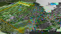
SPH Engineering and GreenValley International synchronize drone technologies for LiDAR data collection and processing
SPH Engineering and GreenValley International partner combining their expertise to deliver drone software technologies for LiDAR data collection and processing. The companies align UgCS mission planning software and LiDAR360 data processing software to optimize the workflow with LiDAR data collected with a UAV. The partnership is ready to provide a full end-to-end software toolchain for airborne LiDAR applications. It includes flight planning and data collection (done with UgCS) and data pr...
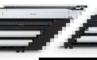
Epson Now Shipping New High-Speed, Compact SureColor T7770D 44-Inch Technical, CAD and Graphics Printer
Wide-Format Dual Roll Printer Features Innovative Design and Delivers Fastest in Class Print Speeds1 for Technical Professionals and Reprographics Providers LOS ALAMITOS, Calif. – With a space-saving design to fit into office spaces and production environments previously not possible, Epson today announced availability for the new SureColor® T7770D 44-inch dual roll printer. Featuring an innovative, compact design, the technical printer is the first available model in the new line of p...
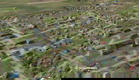
Presagis Extends 3D Tiles Next Workflow into Esri ArcGIS Pro
The 3D Environments Add-In for ArcGIS Pro lets users convert 3D Tiles data into i3S files while preserving domain schemas, such as the One World Terrain (OWT) Ground-Warfighter Geospatial Data Model (GGDM). Montreal, Canada — Presagis, a global leader in 3D advanced modelling and simulation software, is releasing the 3D Environments Add-In application for Esri’s ArcGIS Pro. 3D Environments allows ArcGIS users to rapidly transform 3D Tiles Next data formats, such as One World Terrain, int...

Queen’s researcher develops new sensor which provides early warning of bridge damage
A new prototype sensor that provides an early warning signal if a bridge is at risk of scour – the number one cause of bridge collapse globally – has been developed by a Queen’s University Belfast researcher. Scour is erosion of riverbeds and banks, which can cause major bridge structural failure problems. Dr Myra Lydon has been working on a sensor since last year to tackle the problem. An initial prototype senor has been developed in partnership with Somni Solutions Ltd and testing has now...
Stormwater Interview with Robert Page, P.E., Vice President, HNTB

TriMet’s Banfield Type 1 Substation Replacement Project

February Issue 2026
