
Trimble Introduces Horizontal Steering Control, Automatic Screed Width Control For Vogele Asphalt Pavers
Trimble Roadworks 2.10 Marks Important Step in Trimble's Path Toward Autonomy WESTMINSTER, Colo.- Trimble (NASDAQ: TRMB) introduced today the Trimble® Roadworks Paving Control Platform version 2.10 with Horizontal Steering Control for Vögele Navitronic asphalt pavers. The addition of Horizontal Steering Control and automatic screed width control for Vögele pavers is another important step forward in Trimble's path toward machine control autonomy. Trimble Roadworks version 2.10 with Horiz...
GSSI Releases PaveScan® RDM 2.0 Asphalt Density Assessment Tool
GSSI, the world’s leading manufacturer of ground penetrating radar (GPR) equipment, announces PaveScan® RDM 2.0 – an innovative asphalt density assessment tool that provides accurate real-time measurements to ensure pavement life and quality. GSSI unveiled PaveScan® RDM 2.0 for the U.S. and Canada at the Transportation Research Board 2020 Conference in January. PaveScan 2.0 incorporates a new sensor design built specifically for the extremes of the asphalt paving environment, foldable deploym...

Digital Construction Works Announces Availability of JDLink Connectivity with the DCW Integrations Platform
DCW Integrations Platform Marketplace – View of JDLink New connection now available in both John Deere and DCW Integrations Marketplaces MUNICH, GERMANY – Bauma World Trade Fair – October 24, 2022 - Digital Construction Works (DCW), a leading construction software integrations and solutions company, announces the availability of JDLink Connectivity, a John Deere wireless connectivity solution in its DCW Integrations Platform as a service (iPaaS) Marketplace. The JDLink integration...
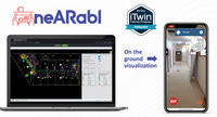
Nearabl Inc., maker of augmented reality-based indoor navigation technology, adopts the Bentley iTwin platform to expand infrastructure deployments
Nearabl Inc. achieves “Powered by iTwin” designation and becomes an iTwin Premier Partner, joining a growing digital twin ecosystem to scale infrastructure deployments globally New York, N.Y. –Today, Nearabl Inc., the metaverse of accessibility company, announced a partnership with Bentley Systems, Incorporated (Nasdaq: BSY), the infrastructure engineering software company, to expand the use of its technology within the global infrastructure, construction, and design industries. The comp...
Leica Geosystems launches next-generation Leica iCON gps 160 — the most versatile construction Smart Antenna
(Heerbrugg, Switzerland) Leica Geosystems, part of Hexagon, today announced the launch of Leica iCON gps 160 — a significantly enhanced, next-generation construction Smart Antenna with features that increase productivity in all stakeout and measurement applications on the jobsite. The Leica iCON construction portfolio offers a broad range of Smart Antennas to fit every construction professional’s needs. From basic level to sophisticated high-end applications, Leica Geosystems’ Smart Antennas...
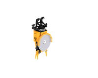
Brokk to Showcase New Innovations at Bauma 2022
The Brokk Grapple Saw 15 is two attachments in one. It can cut metal pipes with a diameter of up to approximately 200 millimeters (7.87 inches) and grab and sort material without changing the attachment – or creating sparks. SKELLEFTEA, Sweden. — Brokk, the world’s leading manufacturer of remote-controlled demolition robots, will introduce three new products and showcase other innovations at Bauma 2022 in Munich, Germany. The new products include the Brokk Grapple Saw (BGS 15), the Bro...

Vexcel Imaging unveils its new UltraNav version 7 including a new partnership with TopoFlight
Graz, Austria: From the Intergeo 2022 in Essen, Germany, Vexcel Imaging introduces the next version of UltraNav, its all-in-one Flight Management and direct georeferencing solution. UltraNav version 7 guides customers every step of the way from 3D Flight Planning to real-time navigation and quality control during flight to post-processing GNSS/INS data. To offer this integrated solution, Vexcel Imaging entered into a new partnership with TopoFlight for flight planning/management and continues it...
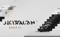
Vexcel introduces new UltraCam Eagle 4.1 photogrammetric aerial camera
Graz, Austria: Vexcel Imaging today announces the release of the new UltraCam Eagle 4.1, the pinnacle of nadir photogrammetric aerial camera systems increasing flight efficiency at truly mapping-grade image quality for precise analysis and interpretation. Based on Vexcel’s ground-breaking 4th generation camera technology, the UltraCam Eagle 4.1 collects high-resolution panchromatic, R, G, B and NIR information at over 500 Megapixels—an impressive footprint that can be exploited at different...

FARO Releases Focus Core Laser Scanner
Lake Mary, Fla – FARO® Technologies, Inc. (Nasdaq: FARO), a global leader in 4D digital reality solutions, today announced the release of the FARO® Focus Core Laser Scanner. The new Focus Core broadens the Focus family’s potential range of applications by providing the ideal combination of price and performance on the market. Fully integrated into FARO’s workflow solutions for application-specific insights, Focus Core uniquely serves the company’s key markets in construction, building operations...
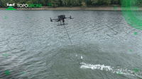
TOPODRONE advances airborne bathymetric surveying with AQUAMAPPER launch at INTERGEO 2022
Montreux, Switzerland – TOPODRONE, a Swiss based designer and manufacturer of high-precision LiDAR equipment for installation on drones, vehicles and backpacks, launches AQUAMAPPER, a UAV-based solution for bathymetric surveying and marine construction. The new multitasking data collecting device and TOPODRONE LiDAR ULTRA equipment have been successfully used together for airborne surveying at a highway construction project in Romania, EU to deliver a full digital twin of a studied area. AQU...
Stormwater Interview with Robert Page, P.E., Vice President, HNTB

TriMet’s Banfield Type 1 Substation Replacement Project

February Issue 2026
