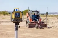
Topcon expands Compact Solutions Portfolio with 2D-MC automatic grade control solution for compact track loaders
LAS VEGAS, Nev. – Topcon Positioning Systems has announced 2D-MC, an automatic grade control solution for compact track loaders. Now available in North America, 2D-MC is a low-cost 2D machine control system that is designed to be installed directly onto select grading attachments. Connecting directly to the machine’s controls and an easy-to-use wireless display, the solution works along with familiar rotary laser technology to provide simplified operational visibility, with all the information n...

ALLPLAN and Solibri Facilitate Higher Quality Models for Optimum Buildability
Munich, January 19, 2023 – ALLPLAN, the global provider of BIM solutions for the AEC industry, today announced that Solibri Inside will be available from within the Allplan software. The newly developed service offering from Solibri provides design model checking facilities for Allplan users. This newly enabled digital workflow solution enables quality assurance where it matters, at the source of every construction project – during the design phase, for optimum buildability. “This development...

HDR Creates Industry-First Customizable Multimodal Tool for Analyzing Airport Landside Traffic
OMAHA, Neb. — HDR has developed an industry-first Airport Landside Multimodal Demand Analysis Tool to help airports identify and explore mobility improvements and management strategies. As airports plan their growth, a better traffic demand analysis enhances project planning, improves the experience for travelers and ultimately saves airports time and money. Previous processes have provided segmented and isolated analysis of individual modes of transportation that must be manually aggregated....
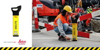
Leica Geosystems simplifies utility detection and increases site safety with new intuitive locator technology
The new Leica DD175 with built-in GPS positioning and data logging for on-site tracking. Heerbrugg, Switzerland, 18 January 2023: Leica Geosystems, part of Hexagon, today announced its latest solution for utility and excavation professionals. The new Leica DD175 utility locator and Leica DA175 signal transmitter complement the existing Leica DD100 series and help operators easily detect underground utilities to ensure site workers’ safety. Locating the position of underground cables an...
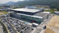
SolarEdge Begins Shipment of New Battery Cell Line for Stationary Energy Storage Applications
SolarEdge’s Sella 2 battery cell manufacturing facility in South Korea SolarEdge battery cells are manufactured at Sella 2, the company’s new battery cell manufacturing facility in South Korea MILPITAS, Calif. – Janua – SolarEdge Technologies, Inc. (“SolarEdge” or the “Company”) (NASDAQ: SEDG), a global leader in smart energy technology, announced today that its Energy Storage division has begun shipping new battery cells designed for stationary energy storage applications. The new...

System-K Concrete Extends the Service Life of Concrete Dam Caps
Microfiber-reinforced shrinkage-compensating cement ensures dam's ongoing structural integrity. Jennings Randolph Lake and dam was built by the U.S. Army Corps of Engineers to improve water quality along the North Branch of the Potomac River and provide flood control. Made of stone and rock, the dam rises nearly 300 feet from the bottom of Jennings Randolph Lake and stretches more than 2,000 feet across the valley. The lake and its beaches serve as both a recreation destination for tourists...
Navigate New Waters with UltraMap 6.0
Graz, Austria: Vexcel Imaging today releases the latest version of its all-in-one photogrammetric software suite UltraMap, with sophisticated and best-in-class water handling features, an enhanced Ortho module performance and a redesigned Ortho reprocessing workflow. UltraMap v6.0 introduces True Pixel Processing (TPP), a proprietary raw data processing approach in the Essentials module and supports professional data production for the recently launched UltraCam Eagle 4.1. The new highly auto...
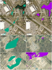
Artificial Intelligence Deep Learning Model for Mapping Wetlands Yields 94% Accuracy
Chesapeake Conservancy’s Data Science Team Publishes Article in “Science of the Total Environment” Annapolis, MD – Chesapeake Conservancy’s data science team developed an artificial intelligence deep learning model for mapping wetlands, which resulted in 94% accuracy. Supported by EPRI, an independent, non-profit energy research and development institute; Lincoln Electric System; and the Grayce B. Kerr Fund, Inc., this method for wetland mapping could deliver important outcomes for prote...

Vectorworks, Inc. Announces New Cloud and Mobile Enhancements Built on Apple Technology
New Features in Vectorworks Cloud Services and the Nomad Mobile App use Advanced Technology to Improve Efficiency and Save Designers Time. Columbia, MD — Global design and BIM software provider Vectorworks, Inc. has released key updates to the Vectorworks 2023 product line focused on providing users with a more efficient and reliable experience on Vectorworks Cloud Services and the Vectorworks Nomad mobile app utilizing Apple’s innovative technology. “We are using the power of the Clo...

Healixa to produce device to create potable water from atmosphere
New York, NY – As many parts of the world continue to struggle with drought, Healixa is about to begin manufacturing a new device that will help provide potable water to people who live in areas with no or limited access to drinkable water. Healixa is set to produce the four-square-foot product called The Global AquaDuct. One Global AquaDuct unit can provide 200 liters (53 gallons) of water a day out of the atmosphere using a solar panel as the energy source. The device freezes water vapor, t...
Stormwater Interview with Robert Page, P.E., Vice President, HNTB

TriMet’s Banfield Type 1 Substation Replacement Project

February Issue 2026
