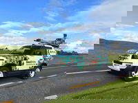
Murphy Geospatial expand services to celebrate 40th anniversary
Geospatial leader Murphy Geospatial, is launching a bespoke mobile-mapping technology to support faster and more accurate geospatial data capture in the built environment. The eye-catching vehicle, called GeoDrive, can easily capture up to 100km of geospatial survey data in just one day. In a world where the sustainability and maintenance of infrastructure assets are of utmost importance, Murphy Geospatial plays a crucial role by providing accurate geospatial data. This data empowers asset ow...

A compact underwater robot providing a safer alternative for underwater inspection, search and maintenance
Professional divers and the Tethys ROV after an underwater inspection operation. Divers can face difficult and dangerous conditions when performing essential underwater inspection, search and maintenance. Now a new Remotely Operated Vehicle (ROV) from Switzerland’s Tethys Robotics is providing a much safer alternative. Find out how a Nortek DVL is being used to complete the navigation solution for this compact robot, while maintaining navigational accuracy in the most challenging un...
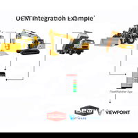
FleetWatcher Integration Enhances Functionality of B2W Software
(Indianapolis, IN) – FleetWatcher integrates with B2W Software to enhance its functionality, saving users of both platforms time while significantly improving accuracy. Machine hour readings from FleetWatcher equipped assets flow seamlessly through to populate B2W modules, thus eliminating the manual input of this information. In addition to saving administrative time, this automatic data transfer significantly enhances accuracy. Because data is tied to equipment activity, the real-time data de...
Powerbox’s COTS/MOTS 1200W power supplies ideal for defense and harsh environments
Powerbox, one of Europe’s largest power supply companies and a leading force for four decades in optimizing power solutions for demanding applications, has announced the release of its new ruggedized 1200W AC/DC power supply for ground based defense applications and harsh industrial environments. In metal chassis format with a baseplate for conduction cooling, the OFD1200A series can be used with a baseplate operating temperature range of -40 up to +95 degrees C. For extremely demanding applicat...

Enscape for Mac Now Available for Vectorworks
Now, All Vectorworks Users Can Harness the Power of the Cutting-Edge Rapid Visualization Plugin. Columbia, MD — Chaos, the world’s largest 3D visualization company and a member of the Vectorworks Partner Network, has extended Enscape for Mac, directly connecting its intuitive real-time visualization tools to the Vectorworks platform on Mac OS. With full integration into Vectorworks, architects and designers can explore high-quality 3D walkthroughs at every stage of the design process, y...

SimActive Accelerates Point Cloud Generation with Version 10.1
Montreal, Canada, October 17th, 2023 – SimActive Inc., a world-leading developer of photogrammetry software, announces the release of Correlator3D Version 10.1. Point clouds and digital surface models (DSMs) are now generated at twice the speed compared to previous versions. The new version reduces processing times by half, which represents a significant technological advance. As an example, a point cloud can be produced from 300 drone images in less than 8 minutes on a single standard PC....

First hydraulic electric crane joins Mammoet fleet
Official handover of the new Mammoet LTC 1050-3.1E. 50 tonne compact crane expands zero emission lifting options for customers Mammoet has added the first electric hydraulic crane to its fleet: the Liebherr LTC 1050-3.1E. Its lifting movements can be powered electrically with full performance, generating zero emissions on site. Heavy construction projects across all industry sectors are seeking to reduce the carbon impact of their operations, to meet strict regulatory requirements...
Trimble Monitoring Software Expands Sensor Support to Deliver Broader Rail and Structural Deformation Analytics for Survey, Monitoring and Construction Professionals
Trimble 4D Control increases flexibility, ease of use and security BERLIN, Germany – Trimble (NASDAQ: TRMB) announced today at the INTERGEO conference the latest release of Trimble® 4D (T4D) Control™ software, version 6.5, expanding rail track monitoring capabilities to address a wider range of standards and specifications. This update also adds support for Syscom Instruments acceleration sensors for event-based monitoring of ground motion, as well as updating authentication methods for...

Vectorworks, Inc. Announces a Colorful Update to its 2024 Product Line
Vectorworks 2024 Update 1 Includes an Innovative NCS+ Pro Integration, User Experience Enhancements and New Feature Improvements. Columbia, MD (October 11, 2023) — Global design and BIM software provider Vectorworks, Inc. has released its first update for the Vectorworks 2024 product line, unveiling a new partnership with NCS Colour, the leading provider of color communication solutions and delivering updates designed to enhance user experience and introduce improvements to newly added...

Revolutionizing 3D Scanning Data Capture, FARO Unveils Orbis Mobile Scanner
The first-to-market hybrid scanner offers mobile and stationary scanning in one device LAKE MARY, Fla.- FARO® Technologies (Nasdaq: FARO), a pioneer in the field of 3D measurement, imaging, and realization technology is proud to announce the release of the FARO® Orbis™ Mobile Scanner, a groundbreaking advancement set to redefine 3D reality capture. Orbis is the first to market hybrid SLAM scanner that can be used for both mobile and stationary data capture in one device. Offering local or cl...
Stormwater Interview with Robert Page, P.E., Vice President, HNTB

TriMet’s Banfield Type 1 Substation Replacement Project

February Issue 2026
