Latest Surfer® Mapping and 3D Visualization Package from Golden Software Gives Users Comprehensive View of Subsurface Data
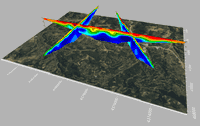
Import imagery, such as PNG files of geophysical profiles, and position the images in any orientation! Import any georeferenced images, such as an aerial image in GeoTIFF format, and it is placed directly in the correct location. GOLDEN, Colorado, 13 February 2024 – Golden Software has further enhanced the 3D visualization capabilities of its Surfer mapping and 3D visualization software to give users a complete picture of their subsurface data. The expanded visualization tools in the lat...

Esri Releases New Landsat Satellite Data App to View and Analyze Land Changes
andsat Explorer Makes Longest-Running Continuous Satellite Imagery More Accessible for Decision-Makers REDLANDS, Calif.—February 13, 2024—Esri, the global leader in mapping and location intelligence, announces the launch of Landsat Explorer, a groundbreaking online app that makes it easier than ever for organizations to access and analyze multispectral imagery from Landsat satellite missions. Remote sensing and earth observation imagery play a crucial role in helping organizations at local, r...
Trimble and DroneDeploy Introduce Premier Positioning Accuracy and Streamlined Workflow for Reality Capture from Drones
RTX-based cloud positioning service expands project opportunities for drone mapping DENVER – GEO WEEK (Booth# 1001) – Trimble (NASDAQ: TRMB) announced today the integration of the Trimble Applanix POSPac CloudⓇ post-processed kinematic (PPK) GNSS positioning service, featuring CenterPointⓇ RTX, with the drone mapping and data collection capabilities of DroneDeploy’s reality capture platform. With the Trimble cloud positioning service, DroneDeploy customers can expect centimeter-level acc...

DJI Launches Its First Intelligent 3D Model Editing Software DJI Modify
Makes repairing common 3D model defects simple and efficient January 18, 2024 – DJI, the world’s leader in civil drones and creative camera technology, today introduced DJI Modify, the company’s first intelligent 3D model editing software. This complementary solution pairs seamlessly with DJI’s enterprise drones and 3D modeling and mapping software, DJI Terra, forming a comprehensive solution for aerial surveying, modeling, and model editing, to meet the operational needs for surveying,...

Trimble Introduces MX90 Mobile Mapping System
Trimble announced today the leading-edge Trimble® MX90 mobile mapping system. With state-of-the-art Trimble GNSS and inertial technology, when combined with Trimble field and office software, the Trimble MX90 provides a complete field-to-finish mobile mapping solution that enables powerful workflows for data capture, processing and analysis. Richer Data for Large-Scale Scanning & Mobile Mapping Projects The vehicle- or train-mounted MX90 rapidly captures highly detailed laser scans an...

Exyn Unveils Nexys: A Fully Modular 3D Mapping Solution for Complex and Challenging Environments
GEOWEEK, FEBRUARY – Exyn Technologies, a pioneer in autonomous robotics, today announced the launch of Exyn Nexys, a revolutionary modular 3D mapping solution. Designed for professionals in mining, construction, AEC, and geospatial industries, Nexys sets a new standard in autonomous mapping technology, offering unparalleled flexibility, speed, and accuracy in the most demanding surveying and inspection environments. Unmatched Modularity for Every Mapping Scenario Nexys’ groundbreaking modu...

A New Standard for Material Testers: 'Connected CMT Machines' Promise Speed, Accuracy
Does your machine 'know' what it's testing? Forney introduces Connected controls to renowned fleet of construction materials testing machines. ZELIENOPLE, Pa., February 6, 2024-- Forney LP, the leading manufacturer of construction materials testing (CMT) machines, equipment and software, recently launched a new type of machine that eliminates the possibility of specimen misidentification at the machine. Using a Forney Connected Machine, a technician can load and test a specimen twice as fast...

Autodesk Informed Design Unlocks Industrialized Construction to Connect Design and Make Workflows
Autodesk launches Autodesk Informed Design to unlock industrialized construction for building design professionals and manufacturers. Autodesk Informed Design connects design and make workflows from day one, to streamline the building design and construction process. Industrialized construction is the future of the AECO industry; it will help deliver projects quicker, with higher quality and with less waste. SAN FRANCISCO – Autodesk, Inc. (NASDAQ: ADSK) today unveiled Autodesk Info...
New Esri UK partner Temple creates biodiversity net gain assessment tool
Streamlined workflow helps users meet England's new legislation Temple, one of the UK’s leading environment, planning and sustainability consultancies, has joined the Esri UK partner network as a Silver Partner. The new partnership enables Temple to use Esri’s GIS (Geographic Information System) technology, combined with its environmental expertise to develop innovative new software solutions for clients. The UKHab and BNG Survey App is the first application to be launched, to help AE...

Trimble Announces Three New Products
Trimble SiteVision Software 5.0 is the latest version of the company’s high accuracy outdoor augmented reality system, now with a new 3D scan tool. The 3D scan app allows customers to use LiDAR sensors available on some Apple Pro devices to capture high-accuracy and instantaneously georeferenced point clouds with a workflow as easy as taking a picture. Combining the power of scanning and precision in a mobile solution, SiteVision 5.0 enables users to create as-builts of the job site on the go,...
Stormwater Interview with Robert Page, P.E., Vice President, HNTB

TriMet’s Banfield Type 1 Substation Replacement Project

February Issue 2026
