
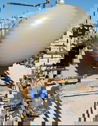
Denso releases it’s first NSF-certified corrosion protection lining/coating for potable water pipes and tanks
Denso, Inc. releases its first NSF-certified corrosion protection lining/coating for potable water pipes and tanks. This two-part ultra-high solid lining is low-VOC (>98 vol% solids) and drinking water safe for fittings, valves, meters and pumps 6 inches in diameter and greater, potable water pipes that are 36 inches in diameter and greater, as well as 10,000-gallon storage tanks and greater. The Archco 426 does not require any induction and may be easily applied in one or two coats directly to...

IMAGINiT Technologies Unveils Clarity 2025
IMAGINiT Technologies launched the latest version of Clarity, a task automation and analytics tool for Autodesk® Revit® and BIM 360® products. New features in the IMAGINiT Clarity 2025 release include integration with Oracle Aconex, enhanced functionality with Autodesk Revit Error Resolution, and advancements to the Clarity Space Programming Module. These updates improve project management efficiency and streamline workflows for firms on Engineering News Record’s Top 500 Design Firms list as wel...

Satellite-Based Sensors Provide Valuable Data for Pipeline Monitoring, Crop Production, and More
ISS National Lab Plays Key Role in Advancing Startup’s Sensor Technology KENNEDY SPACE CENTER (FL) – Using satellite-based hyperspectral sensors that can capture images of Earth beyond the visible light we can see with our eyes, startup Orbital Sidekick provides valuable global monitoring services to customers around the world. So far, the company has launched five commercial satellites, two of which went up in March, and has plans to launch a sixth later this year. Co-founder and CEO Dan...
Using Electromagnetic Flowmeters for Better Management of Produced Water
By Ron Garcia, Strategic Business Director, KROHNE Group The oil and gas industry is increasingly relying on electromagnetic flowmeters, commonly known as magmeters, as a crucial tool to address the ever-growing challenges of managing produced water – the water that is brought to the surface during oil and gas extraction operations. Not only is the volume of produced water surging, but at the same time, the industry faces mounting constraints on its use and disposal. These growing financia...
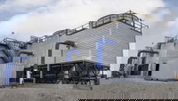
Marmon Industrial Water Launches Ecodyne Modular Cooling Towers
New offering enables seamless installation of cooling tower cells without disrupting production BURLINGTON, Ont. (May 15, 2024) – With over 60 years of expertise in the water treatment industry, Marmon Industrial Water is unveiling Ecodyne Modular Cooling Towers, a solution for new and retrofit builds. The factory assembled modules allow plants to seamlessly replace one cell at a time while those adjacent remain fully operational, reducing downtime and shortening field installation time...

ALLPLAN launches international learning platform ALLPLAN LEARN NOW
ALLPLAN LEARN NOW is ALLPLAN's new learning platform with numerous freely accessible learning opportunities for the entire planning and construction process. Copyright: ALLPLAN. New digital learning opportunities and materials for Allplan Munich, May 13, 2024 - ALLPLAN, provider of BIM solutions for the AEC industry, today announces the international launch of its learning platform ALLPLAN LEARN NOW. It is now available also to customers in France, Austria, Switzerland, Italy, Spain,...

HCSS HeavyBid Pre-Construction Eases Estimating Workflow
Simplifying Pre-Construction Project Tracking for Construction Professionals Sugar Land, Texas – HCSS, the leading provider of software helping heavy civil construction businesses streamline the entire lifecycle of their projects, highlights HeavyBid Pre-Construction, a cutting-edge project-tracking solution designed to streamline the estimating process for construction professionals. HeavyBid Pre-Construction allows pre-construction teams to create activities and bid items instantly, either...
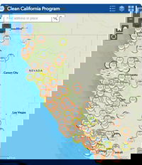
Caltrans Launches Digital Map Highlighting More than 300 Clean California Projects Transforming Communities Across the State
Interactive features allow users to locate, view, and learn more about beautification efforts SACRAMENTO – Just ahead of national infrastructure week, Caltrans today launched a new interactive map that spotlights hundreds of beautification projects funded by Clean California. The geographic information system (GIS) mapping tool offers users location-specific, multilayered data that demonstrates the transformative impact these community-focused improvements and infrastructure investments are...

Esri Releases Latest Land Cover Map with Updated Sentinel-2 Satellite Data
Annual 10-Meter 2017–2023 High-Resolution Maps Available in Esri’s ArcGIS Living Atlas of the World REDLANDS, Calif. —Esri, the global leader in location intelligence, in its partnership with Impact Observatory, has released an updated global land-use/land-cover map of the world based on the most up-to-date 10-meter Sentinel-2 satellite data. In the update, the Sentinel-2 10m Land Use/Land Cover Time Series includes new data from 2023, expanding the series to include global coverage from 2017...

Autodesk Unveils Research Project Bernini for Generative AI 3D Shape Creation
Project Bernini is a research effort focused on developing generative AI for Design and Make industries. The first experimental Bernini model quickly generates functional 3D shapes from a variety of inputs including 2D images, text, voxels and point clouds. While Project Bernini is exciting and at the leading edge of generative AI, its models will become increasingly useful and compelling when trained on larger, higher-quality professional datasets. For the Design and Make industries, a...
Stormwater Interview with Robert Page, P.E., Vice President, HNTB

TriMet’s Banfield Type 1 Substation Replacement Project

February Issue 2026
