
DuPont Water Solutions Launches WAVE PRO for Ultrafiltration Modeling
Most comprehensive web-based modeling tool for ultrafiltration water treatment processes DuPont Water Solutions recently launched WAVE PRO, a powerful online modeling tool for a variety of ultrafiltration (UF) water treatment applications – including drinking water, industrial utility water, wastewater, and seawater desalination. This next generation of the Water Application Value Engine (WAVE), WAVE PRO for UF guides water professionals through the water treatment design process for...

Aalberts integrated piping systems’ "Apollo"® backflow solutions: safeguarding water quality with sustainable protection
Backflow prevention solutions deliver advanced protection, compliance, and ease of maintenance for critical water systems Aalberts integrated piping systems (IPS), a global leader in advanced integrated piping systems for the distribution and control of liquids and gasses, highlights its "Apollo"® backflow product line, delivering superior protection against water contamination across a variety of applications. Designed to meet stringent safety standards, "Apollo"® backflow prevention solutio...

Esri Adds California Live Camera Feeds to ArcGIS for Better Awareness of Wildfires and Other Disasters
New Map Layer Provides Critical Real-Time Information to Emergency Responders and the Public REDLANDS, Calif.—Esri, the global leader in location intelligence, and the University of California San Diego’s ALERTCalifornia program have launched a new ready-to-use map layer that provides instant access to live camera feeds across California. This collaboration comes at a critical time, as the state faces increasingly frequent and severe natural disasters, particularly wildfires, that threaten p...

Topcon 3D leveling system now compatible with new Dynapac Highway Paver series
MUNICH — Topcon Positioning Systems has announced that its MC-Max Asphalt paving system has been confirmed compatible with the Dynapac SD25 and XD25 Highway Paver series, enabling automatic control of height, steering, and screed width for enhanced paving precision and efficiency. Following successful testing, Dynapac has issued formal confirmation of the integration’s effectiveness. This development streamlines the implementation of Topcon advanced machine control technology for Dynapac paver o...

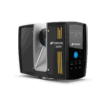
Topcon launches CR-H1 handheld reality capture solution for maximum mobility
MUNICH — Topcon Positioning Systems has announced the CR-H1, a handheld solution that represents one of the latest additions to the company’s Capture Reality portfolio of mass data solutions. The system utilizes PIX4Dcatch, a specialized application that runs on iPhone devices with integrated LiDAR that collects images and employs photogrammetry to create detailed, full-color 3D point clouds. The iPhone connects to Topcon’s HiPer CR receiver, enabling the application to collect georeferenced ima...
Topcon introduces solutions for 3D mass data workflows
MUNICH — Topcon Positioning Systems has announced new technology solutions for 3D mass data workflows. Enhancements to the Topcon Collage Site software solution provide new workflow capabilities designed to allow for the real-time acquisition and processing of data more accurately, efficiently, and quickly to provide the user with greater productivity. Collage Site software allows a single operator to scan, process, and view complete georeferenced point clouds in real time while still in the...

Dig Smarter, Not Harder: Trimble Tech Turns Excavators into Precision Construction Tool
Introducing the Trimble Siteworks Machine Guidance Module for Tilt Buckets WESTMINSTER, Colo., April 7, 2025 - Trimble® (Nasdaq: TRMB) today announced the availability of its Trimble Siteworks Machine Guidance Module for tilt bucket attachments. By integrating the full range of motion of the tilt bucket's cutting edge into the Siteworks machine guidance and layout software, field operators can now achieve precise grading and leveling, efficient ditch cleaning and shaping, accurate backfilling a...
Trimble and Liebherr Introduce Trimble Ready Factory Option for Liebherr PR 776 Generation 8 Bulldozers
Alexander Katrycz, Head of Marketing at Liebherr-Werk Telfs GmbH (left) and Scott Crozier, Vice President, Civil Construction Field Systems at Trimble (right) at bauma 2025 event. (PRNewsfoto/Trimble) TELFS, Austria and WESTMINSTER, Colo., April 7, 2025- Trimble® (Nasdaq: TRMB) and Liebherr announced the introduction of a Trimble Ready® factory option for the new line of Liebherr PR 776 Generation 8 bulldozers, the latest model from Liebherr's competitive dozer lineup to feature th...
Esri Helps Bring Up-to-Date Road Closure Information To Consumer Mapping Apps
ArcGIS Users Can Provide Road Closure Data to Apple Maps and TomTom to Help Improve Travel for Motorists REDLANDS, Calif. — Esri, the global leader in GIS technology and location intelligence, has enhanced its popular Community Maps Program to make sharing of road closures much easier with the Road Closures solution. This new solution in Esri’s ArcGIS, the leading and most comprehensive geospatial platform, bridges the gap between government agencies managing timely road updates and the publi...

What’s New in Civil 3D 2026: Experience New Time-Savings and Performance Gains
Welcome to Autodesk Civil 3D 2026, the newest release to help you improve project timelines, increase accuracy, deepen collaboration, and make data-driven decisions with greater precision. Take advantage of the new features and capabilities—many of which were suggested directly by Civil 3D customers—to transform how you design, collaborate, and deliver more resilient infrastructure. Let’s take a deeper look at the enhancements now available. Automate drainage design With the integration of...
Stormwater Interview with Robert Page, P.E., Vice President, HNTB

TriMet’s Banfield Type 1 Substation Replacement Project

February Issue 2026
