
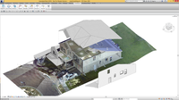
Leica Geosystems’ New Miniaturized 3D Imaging Laser Scanner Simplifies the Collection of As-Built Reality Capture Data for Architecture, Engineering, Construction, and Design
Norcross, Georgia – Leica Geosystems, a leader in the world of measurement and survey for nearly 200 years, has redefined what’s possible in the imaging laser scanner market with the introduction of the BLK360, the world’s smallest 3D imaging laser scanner. The BLK360 will transform the way architects, engineers, and construction professionals measure, photograph and document spaces. Users simply place the lightweight BLK360 on a level surface or tripod and with the push of a single button, i...
FARO Introduces PointSense 18.0 Suite for Construction and Architecture
Lake Mary, FL - FARO® (NASDAQ:FARO), the world’s most trusted source for 3D measurement and imaging solutions for factory metrology, construction BIM/CIM, product design, public safety forensics, and 3D solutions, announces the availability of the FARO® PointSense 18.0 software suite (http://www.faro.com/aecsoftware18-0/). This robust software platform evolution delivers seamless integration into the latest 2018 AutoCAD® and Revit® design tools, a better user experience, improved software handli...

Autodesk Authorized Publisher Announces Autodesk 2018 Courseware Roadmap
Owings Mills, MD — April 24, 2017 — Rand Worldwide (OTCBB: RWWI), a global leader in providing technology solutions to organizations with engineering design and information technology requirements, today announced that its courseware division, ASCENT – Center for Technical Knowledge, a member of the Autodesk Authorized Publisher Program, has released 21 updated training guides for Autodesk 2018 software. ASCENT’s complete Autodesk 2018 Courseware Roadmap will include the release of 72 titles. Ne...

Genesis Water Technologies Expands Natural Zeolite Flocculants for Municipal and Industrial Water Treatment
MAITLAND, Fla., April 24, 2017 - Genesis Water Technologies, Inc., a vibrant USA based global water & wastewater treatment solutions company, is excited about the formal introduction and expansion of its natural zeolite based flocculant, called ZeoTurb. Around the world there is an increasing need for environmentally safe and sustainable methods of providing high quality solutions for water and wastewater treatment in both municipal and industrial applications. GWT ZeoTurb is a natural non...

Revit Live 1.8 Release Announced - Revit Live Service Now Available to Revit LT 2018 Users
Make your Autodesk Revit model immersive in one click with the Autodesk Revit Live service. From Revit, send your model to the Revit Live cloud and in just a few minutes, you will have a file that is ready to be opened, explored, and edited in the Autodesk Live Editor. You can shape your audience’s experience by customizing the navigation points, the render style, and time of day. When you are done refining the interactive visualization, you can present or share your design ideas with...
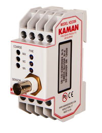
Kaman Measuring Announces KD-2306 Non-Contact Displacement Sensing System
Middletown, CT – The Measuring Division of Kaman Precision Products, Inc., a world leader in the design and manufacture of high-performance, precision non-contact position measuring systems, announces the availability of its KD-2306 single-channel multi-purpose non-contact displacement sensing system. When paired with any of the supported dual and single coil sensors, the KD-2306 becomes an easy-to-use, high precision static and dynamic measuring system. Its DIN rail mount interface makes it ide...
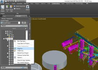
AutoCAD Plant 3D 2018 –Simplified Design from Design Creation, 3D Modeling to Collaboration
This past year has been exciting for the AutoCAD Plant 3D development team. We have added features that further simplify the design process by helping customers easily produce P&IDs, integrate them into a 3D plant design model, and collaborative effectively – all within Plant 3D. This release also paves the way to help customer’s move to the Autodesk Cloud and to BIM solutions. What’s New in Plant 3D 2018 Cloud Based Collaboration This year, we are introducing a new collab...
InfraWorks and AutoCAD Civil 3D 2018: They’re Here!
April 13, 2018. The latest Autodesk InfraWorks and Autodesk AutoCAD Civil 3D 2018 are officially released today. Throughout the year many of you have met with our product managers and development teams; and, many, many more of you have shared your Ideas for product feature enhancements. Your involvement in the development of our solutions is invaluable, helping us bring you the tools you need to conceive, design and construct road, highway, bridge, land, and other infrastructure projects in w...

Procore Users Can Print Plans Faster and Smarter for Much Less
Having printed sets of plans readily available for review is a necessity at building sites and in many other architecture, engineering and construction situations. Often, having plans on paper makes it easier for the project management team to see at a glance both the big picture and granular details in relation to the full project scheme. While tablets and other devices are fantastic in many situations, many industry professionals prefer to view schematics and read text on sharp, crisp printed...

DroneDeploy Integrates with agX to Streamline Planning of Drone Mapping Flights
Stillwater, Okla.- STILLWATER, OK – DroneDeploy, the leading cloud software platform for commercial drones today announced an integration with agX® to help growers more easily capture field maps and analyze aerial data. agX users can now share field boundaries saved in agX with DroneDeploy to simplify the planning of drone mapping flights. Over time, agX and DroneDeploy plan to integrate further to allow seamless sharing of drone images from DroneDeploy to agX. “This integration will provide...
Stormwater Interview with Robert Page, P.E., Vice President, HNTB

TriMet’s Banfield Type 1 Substation Replacement Project

February Issue 2026
