
GeoSLAM Welcomes New Member Of Zeb Family For Indoor + Outdoor Use
The latest innovation from geospatial mapping and monitoring technology specialist, GeoSLAM has launched, with the introduction of the ZEB-HORIZON. Showcased at this year’s Commercial UAV Show, the ZEB-HORIZON is the next generation of handheld 3D laser scanners, capable of rapidly capturing intricate indoor and outdoor measurements on UAVs situated up to 100m away from the subject. The ZEB-HORIZON, which complements the existing ZEB range, is the first new product from the geospatial mapp...

New FLIR InSite Mobile Application Simplifies Inspection Management
WILSONVILLE, Ore. – FLIR Systems, Inc. (NASDAQ: FLIR) announced today the launch of FLIR InSite™, a new mobile application and web portal for organizing client information and thermal inspection data in one location that is easy to access, manage, and share. Ideal for electricians, electrical contractors, and thermography service professionals, the FLIR InSite workflow management tool reduces inspection preparation time, increases efficiency, and helps deliver results quickly. With FLIR InSite,...

Topcon Speakers to Hold Construction Validation Classes at Autodesk University
LIVERMORE, Calif., U.S. – Topcon Positioning Group is participating in the 2018 Autodesk University conference in Las Vegas. At the annual event, Andrew Evans, Topcon product manager for mass data, will host a class titled Construction validation faster than the speed of light. The class will highlight how new advances in technology have made near-real-time construction validation possible. Additionally, Topcon representatives will take part in the Connect and Construct Summit early bird session...

New Release of IMAGINiT Pulse Increases Business Critical Data Sharing
BALTIMORE, MD — Developed to overcome data workflow challenges facing design and manufacturing engineers and architects, IMAGINiT Pulse now offers more integrations with multiple business systems and software platforms as well as support for the Autodesk Vault 2019 product release. Visitors to IMAGINiT Booth #A221 at Autodesk University (AU) 2018 in Las Vegas, NV will see first-hand how they can use Pulse to connect engineering data to other business systems. “Customers who use IMAGINi...
'Spatial Manager v5' Fall Release
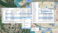
Enjoy a big leap in data management, especially in CAD applications (AutoCAD, BricsCAD and ZWCAD) which have incorporated a powerful and unique Data Grid (already in Desktop) that will allow you to manage the spatial data in your drawings and maps more effectively than ever Recover Data Tables from objects in the drawing, Rename Data Tables, choose the value of a Field from a list of available values when selecting by query, Import and Export user dynamic Background Maps, and many more. BTW,...

Trimble Introduces Satellite-Based RTX Corrections to the Kestrel Seismogeodetic System for Earthquake, Volcano and Infrastructure Monitoring
LAS VEGAS- Trimble (NASDAQ: TRMB) announced today the addition of Trimble RTX™ technology delivered via satellite to its Kestrel™ seismogeodetic system. Pairing uninterrupted, high-quality Global Navigation Satellite System (GNSS) positioning corrections with seismic data—for Earthquake Early Warning (EEW), volcano and infrastructure monitoring of bridges, dams, towers and other civil structures—makes Kestrel an innovative solution for scientists and structural engineers. The announcemen...

Urban Solar Releases Streamline Solar Series - Solar-Powered Area Lighting Systems
BEAVERTON, OR – Urban Solar is pleased to announce the release of an all new solar lighting product line, the Streamline Solar Series. To meet the demands of a growing commercial solar lighting market for a compact and aesthetically-pleasing area lighting solution, the Streamline Solar Series is the first system in Urban Solar’s lineup to incorporate lithium-ion battery technology. Lithium-ion batteries are long-lasting, recyclable and can be replaced by the user at the end of their life-cycle....

Newforma Introduces New APIs for its ConstructEx™ Product and a New Connector with CMiC
Manchester, NH – Newforma, a leader in Project Information Management (PIM) software for architects, engineers, contractors, and owners (AECO) worldwide, today announces the next milestone for its ConstructEx™ product for contractors/construction with the redesign of its API platform. "We believe in a vibrant and open ecosystem of AECO software that works together to improve project delivery and eliminate redundant data entry,” stated Ray DeZenzo, Chief Operating Officer for Newforma. “W...
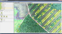
Trimble Announces New Versions of eCognition Software for Photogrammetry and Remote Sensing Professionals
LAS VEGAS — Trimble (NASDAQ: TRMB) announced today eCognition® version 9.4 featuring updates to eCognition Developer and the eCognition Oil Palm Application. Trimble’s eCognition is a software platform for advanced geospatial image analysis for environmental, agriculture, forestry and infrastructure applications.The software extracts accurate geo-information from remote sensing data. eCognition’s intelligent information extraction capabilities accelerate mapping, change detection and object reco...
Trimble Announces Forensics GNSS Solution
LAS VEGAS —Trimble (NASDAQ: TRMB) announced today the launch of the Trimble® Forensics GNSS solution. The solution combines the Trimble T10 tablet or TDC100 handheld with the Trimble Forensics Capture software and the Trimble R4sLE GNSS receiver. The announcement was made at Trimble Dimensions. The solution enhances forensics fieldwork by improving efficiency and broadening the range of data collection technologies available using the same, proven software. Trimble Forensics Capture sof...
Stormwater Interview with Robert Page, P.E., Vice President, HNTB

TriMet’s Banfield Type 1 Substation Replacement Project

February Issue 2026
