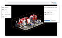
Select and Download Sections of Large Point Clouds Right in Your Browser with NavVis IndoorViewer 2.5
The upcoming release of NavVis IndoorViewer 3D building visualization software will include a new feature to select, crop and download point cloud sections in browser. The beta version of the extended point cloud functionality in NavVis IndoorViewer will be previewed at INTERGEO 2019. Munich, Germany – NavVis, the leading global provider of indoor spatial intelligence technology and enterprise solutions, announces the beta release of NavVis IndoorViewer 2.5. This major software relea...
Vectorworks, Inc. Announces 2020 Version of BIM and Design Software
Experience a smoother workflow with improvements to the VGM level of detail. Columbia, MD — Global design and BIM software provider Vectorworks, Inc. announces the 2020 release of Vectorworks Architect, Landmark, Spotlight, Designer and Fundamentals, as well as 2020 versions of Vision and Braceworks. This newest release brings improved software performance, quality enhancements and new data-driven workflows. “Data and usability are the cornerstones of this year’s product line enhancem...

The Wild and Igloo Vision Partner to Bring Real-Time VR/AR Collaboration to Immersive Shared VR Environments
The Wild and Igloo Vision partner to bring real-time VR/AR collaboration to immersive shared VR environments Portland, OR & Shropshire, UK – 10, September 2019 – Today, Igloo Vision and VR/AR collaboration platform The Wild announced their integration, which will open up even greater possibilities for collaboration and experiential design review for teams working in architecture, engineering, and construction (AEC). Igloo Vision designs and develops immersive 360° projection spaces, along...
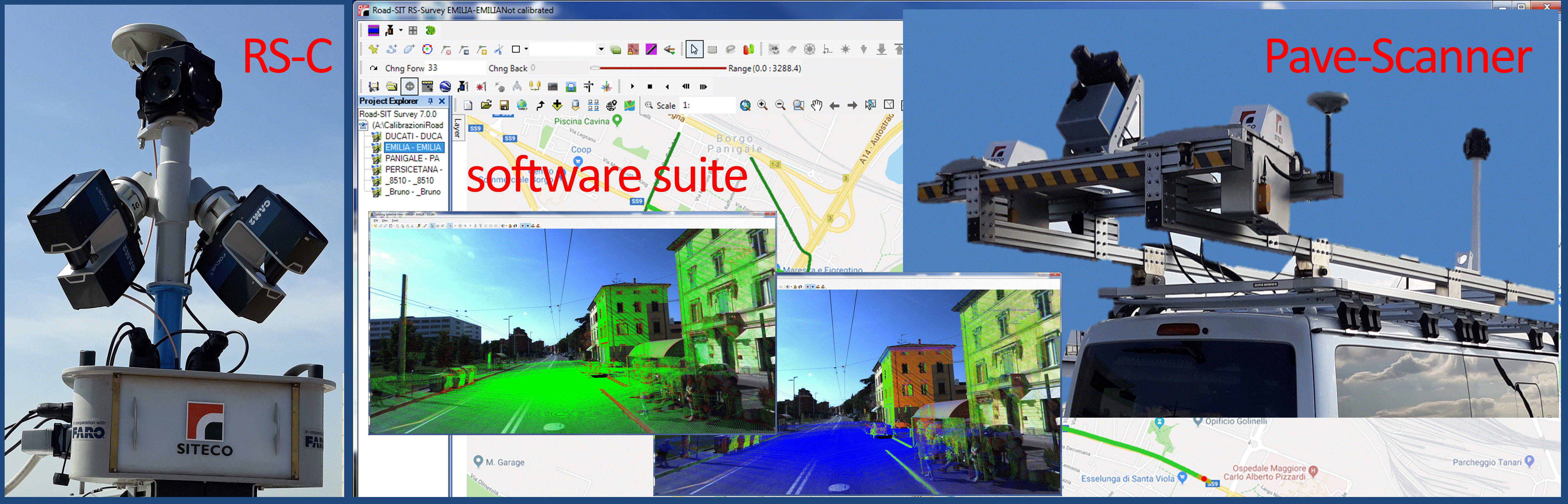
Road-SIT Survey v. 7.5: The Features that Streamline the Survey Work
10 September, 2019, Bologna Italy – SITECO Infomatica SRL will be attending Intergeo 2019 in Stuttgart, Hall 3, Stand B3.025, showcasing the Road-Scanner family of Mobile Mapping Systems and the NEW software release of Road-SIT Survey. Road-SIT Survey is the mobile mapping data application developed by Siteco, fully compatible with the most widespread mobile mapping systems like the Optech-Lynx, Riegl-VMX, Topcon IPS3 and Leica Pegasus. And of course with the well-known Siteco’s Road-Scanner....

Flexible, Adaptable, Strong, Easy to Work With, ACH Foam Technologies’ Molded Polystyrene Foam Is Unlike Anything Else
WESTMINSTER, Colo., Sept. 10, 2019 - It isn’t like any other material - extremely strong yet incredibly lightweight; large but easily moved; durable yet capable of being finely articulated down to the smallest crevice. Molded polystyrene foam from ACH Foam Technologies is being used by sculptors at PLAYTIME to create immersive, animated playscapes and climbable characters. “We use artistry to create truly believable fairytale environments,” says Spencer Smith, a talented sculptor who spends h...

Trimble Announces New Offline Data Transfer and Post-Processing Workflow for Trimble TerraFlex Software
SUNNYVALE, Calif.— Trimble (NASDAQ: TRMB) announced today its Trimble® TerraFlex™ field software now supports the transfer of data between the field and office without the use of Trimble cloud services. The new software workflow—called offline data transfer—is possible through the integration of Trimble TerraFlex and the Trimble Positions™ Desktop add-in for Esri® ArcGIS® Desktop. TerraFlex is a field solution that enables mobile workers to easily collect, manage and edit their geospatial featur...
New Integration for Autodesk Civil 3D
Our partnership with Esri continues to develop, enabling more streamlined flow of data between design tools and GIS. Now, the integration of BIM and GIS has come to Civil 3D! Autodesk® Civil 3D® continues to deliver improvements to design, performance and collaboration efficiencies, enhancing BIM design workflows for larger, more complex infrastructure projects. However, with this latest release – Civil 3D 2020.1 – we are extremely excited to introduce the Autodesk Connector for ArcGIS...
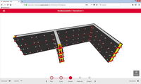
Make your own 3D Formwork drawings
3D Formwork Planning just got simpler: The DUO Planner is here We know how difficult and time consuming it can be to plan your formwork needs and putting material lists together in a very short amount of time. That is why we are very excited to introduce you to our NEW DUO Planner! Our smart, FREE, online tool that with just 5 simple steps it automatically calculates the formwork material required for simple layouts and provides you with 3D drawings! Here is the Link to use the free tool: ...
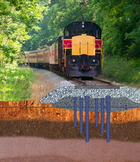
Geopier Foundation Company Launches New GeoSpike Railway Subgrade Improvement System
GeoSpike is an innovative ground improvement method for strengthening weak railroad track subgrades DAVIDSON, NC. (August 26, 2019) Geopier Foundation Company, a world leader in ground improvement solutions, has introduced its newest Intermediate Foundation® solution: the GeoSpike℠ System. This system is a low cost method for strengthening weak railroad track subgrades without removing railroad tracks, tie or ballast. New GeoSpike rail stabilization solution reduces the need for costly re...

Brokk 70 Offers More Power for Confined Spaces
MONROE, Wash. (August 21, 2019) – Brokk, the world’s leading manufacturer of remote-controlled demolition machines, unveiled the Brokk 70 during bauma 2019. Armed with SmartPower™ — the company’s signature intelligent power management system — the smallest electric robot in the Brokk range offers 100% more power than its predecessor, the Brokk 60 II, yet retains the same compact dimensions with only a 133-pound (60-kilogram) weight increase. With the new BHB 105 breaker, the Brokk 70 brings safe...
Stormwater Interview with Robert Page, P.E., Vice President, HNTB

TriMet’s Banfield Type 1 Substation Replacement Project

February Issue 2026
