
Vectorworks, Inc. Brings Ultimate GIS Workflow to AEC and Landscape Professionals
Columbia, MD — GIS helps designers make better decisions. This is why Vectorworks, Inc., a global design and BIM software provider and its partner Esri, the global leader in location intelligence, are bringing Esri’s ArcGIS Online services to AEC and landscape professionals, as well as urban planners and urban designers. The solution offers better and quicker access to GIS imagery, data and geometry and the latest technology available in Vectorworks 2020 software, including Vectorworks Architect...

Cesium Takes City Visualizations Into the 3rd Dimension Through Open-Source Collaboration
Philadelphia – A new open-source initiative by Cesium™, the market leader in streaming 3D geospatial technology will address the need to visualize, analyze, and share the world’s vast and ever-growing collection of 3D geospatial data. Engineering teams from Cesium are working with Uber to add support for 3D Tiles to loaders.gl and deck.gl, two of Uber’s open source geospatial visualization frameworks. Support for 3D Tiles, an open-standard format originally created by Cesium, will enable dec...
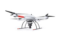
Microdrones is Taking Photogrammetry to New Heights with the mdMapper3000DuoG VHR
Rome, NY - Rome, NY – Microdrones is releasing three new Integrated UAV Systems based on the heavy lifting power, resilience and efficiency of the Microdrones md4-3000 aircraft: the mdMapper3000DuoG VHR, the mdMapper3000DuoG, and the mdMapper3000 PPK. The company has also updated the mdTector1000CH4 LR with a Pergam Laser Methane Falcon sensor for detecting Methane (CH4) and methane-containing gases. Additionally, Microdrones is preparing to release mdInfinity, a new software package t...
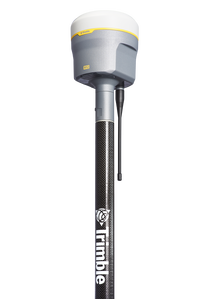
New Trimble R12 Receiver Boosts Surveying Performance
SUNNYVALE, Calif. - Trimble (NASDAQ: TRMB) introduced today the Trimble® R12 GNSS receiver, a high-performance Global Navigation Satellite System (GNSS) surveying solution. Powered by an all new Real Time Kinematic (RTK) and Trimble RTX® positioning engine, it features ground-breaking Trimble ProPoint™ GNSS technology that empowers land surveyors to quickly measure more points in more places than ever before. Surveyors who work in challenging GNSS environments can use the Trimble R12 receiver to...
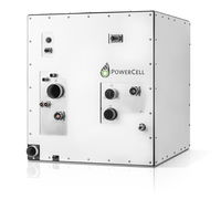
PowerCell to Present New Version of MS-100 Fuel Cell System for Electrification on Land and at Sea
PowerCell Sweden AB (publ) has developed a new and improved version of its MS-100 fuel cell system which will be presented at the Fuel Cell Seminar & Energy Exposition in California on November 5th. The new MS-100 is 30 percent more compact and has improved operating life time as well as robustness for demanding applications on land and at sea. The English version is an in house-translation. In case of any discrepancy, the Swedish text will prevail. The MS-100 fuel cell system has been de...
Eos Releases Underground Infrastructure Mapping Solution for Collector for ArcGIS
Eos Locate™ for Collector for ArcGIS enables utilities to map buried assets with submeter or centimeter accuracy MONTREAL, CANADA — Eos Positioning Systems, Inc.® (Eos) — the leading manufacturer of high-accuracy Arrow GNSS receivers — announced today the release of its highly anticipated underground utility asset-mapping solution: Eos Locate for Collector for ArcGIS. Eos Locate™ for Collector combines three core technologies: Eos Arrow GNSS receivers, Esri Collector, and the Vivax-Metrotech vL...

Autodesk BIM 360 Design Now Offers Anytime, Anywhere, Cloud Collaboration On Projects With Both Infrastructure And Building Features
SAN RAFAEL, Calif. — Autodesk, Inc. (NASDAQ: ADSK) announces the expansion of Autodesk BIM 360 Design, Autodesk’s fastest-growing cloud solution, to include Autodesk Civil 3D. With this announcement, Autodesk now offers one of the most comprehensive solutions enabling teams to collaborate on complex projects with horizontal and vertical structures, nearly anytime, anywhere in a single connected cloud platform. Collaboration for Civil 3D, now included with a BIM 360 Design subscriptio...

LiDARUSA offers new aircraft to carry full range of UAV scanners
Based in Somerville, Alabama, LiDARUSA a global leader in the design and integration of economical LiDAR sensors announced a partnership with Innoflight Technology, a manufacturer specializing in UAV systems for surveying, mapping, and inspection. As a result of the partnership, LiDARUSA is offering the Galaxy 950 platform to carry any of its sensors while consistently providing flight times over 30 minutes. Innoflight and LiDARUSA’s partnership is another step for both companies to offer t...

Bentley Systems Accelerates Focus on Infrastructure Engineering for Digital Cities
The City of Helsinki leveraged Bentley’s reality modeling software to generate a 3D representation of Helsinki as part of its smart city initiative, improving internal services and processes. Image courtesy of City of Helsinki. SINGAPORE – The Year in Infrastructure 2019 Conference – Bentley Systems, Incorporated, the leading global provider of comprehensive software and digital twin cloud services for advancing the design, construction, and operations of infrastructure, today presented i...
Trimble's Compact GNSS Board Adds Flexibility and High-Precision Positioning to Unmanned Aerial Systems
SUNNYVALE, Calif. - Trimble (NASDAQ:TRMB) introduced today a compact, high-precision Global Navigation Satellite System (GNSS) board specifically designed for unmanned aerial systems (UAS)—the Trimble® UAS1. The board's simple connectivity and configuration allow UAS system integrators to easily add satellite-based positioning—with the ability to upgrade its capabilities—using rugged connectors and Trimble's easy-to-use software interface. The new UAS1 incorporates the latest Trimble Maxwell™...
Stormwater Interview with Robert Page, P.E., Vice President, HNTB

TriMet’s Banfield Type 1 Substation Replacement Project

February Issue 2026
