Phase One Announces P3 Drone Payload for Asset Inspection
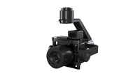
COPENHAGEN – Phase One, a leading developer of digital imaging technologies, today announced the P3 Payload, a versatile solution designed for fast, efficient, and safe inspection of critical infrastructure with an Unmanned Aerial Vehicle (UAV). The P3 Payload includes a Phase One iXM 100MP or 50MP camera, one of the RSM lens options, and a new gimbal with integrated rangefinder. Available in Q2 2021, the P3 Payload is extremely versatile, offered in two configurations to meet a wide range of...

Pinnacle Introduces Next Evolution of Reliability Modeling
Proving out new methodology estimated to reduce facilities’ reliability spending by 10% to 30% PASADENA, TEXAS – Pinnacle, the world’s leading provider of data-driven reliability and integrity programs, today introduces an improved approach to reliability modeling, called Quantitative Reliability Optimization (QRO). This new approach streamlines current reliability methodologies into a single, comprehensive analysis, empowering leaders in processing industries to make smarter decisions at a...

Trimble Announces Release of Tekla 2021 Structural BIM Software Solutions
New Versions Deliver Enhanced Usability, Data-Driven Workflows and Real-Time Collaboration SUNNYVALE, Calif. —Trimble (NASDAQ: TRMB) introduced today the latest versions of its Tekla® software solutions for constructible Building Information Modeling (BIM), structural engineering and steel fabrication management—Tekla Structures 2021, Tekla Structural Designer 2021, Tekla Tedds 2021 and Tekla PowerFab 2021. New Tekla software features and enhancements continue to power data-driven, collabora...

Leica Geosystems Announces BLK3D Update
Leica BLK3D - the in-picture measurement solution (HEERBRUGG, SWITZERLAND, 18 March 2021) – Leica Geosystems, part of Hexagon, today announced the Leica BLK3D update. The new handheld imager has doubled its operating range and in-picture measurement accuracy for many indoor and outdoor applications, such as exterior building measurements for scaffolding, façade, roofing, and architecture projects. The BLK3D users can capture façades of four-storey buildings with centimetre accuracy in seco...

FARO® Introduces BuildIT 2021 Software Suite
Simplifies Workflows & Enhances Ease for Manufacturing, Assembly & Construction LAKE MARY, FL, March 18, 2021 – FARO Technologies, Inc. (Nasdaq: FARO), a global leader for 3D measurement, imaging and realization solutions, today announced the release of its most advanced BuildIT 2021 software suite, which represents the next evolution of this platform that simplifies workflows, improves performance and enhances ease of use. BuildIT offers three individual products – BuildIT Metrology, Buil...

Vectorworks, Inc. Announces Unreal Engine Partnership and Service Pack 3 Release
Major updates include a new real-time rendering connection to Twinmotion and Unreal Engine, a direct connection with Solibri plus a new Vectorworks Cloud Services folder sharing feature for project teams Columbia, MD (March 16, 2021)—Global design and BIM software provider Vectorworks, Inc. has released its third service pack for the Vectorworks 2021 product line focusing on key updates for their architecture, landscape architecture and entertainment design customers. Notable highlights...

New Leica CityMapper-2L configuration enables digital twin creation of cities in complex weather and congested flight operation areas
With a new focal length combination for ultra-high resolution projects or operations when low flying altitude is required, the Leica CityMapper-2 now offers a full product portfolio covering all flying parameters and GSD’s (HEERBRUGG, SWITZERLAND) – Leica Geosystems, part of Hexagon, introduces the new Leica CityMapper-2L configuration specifically designed for airborne urban mapping projects at low altitude operation. Lower flying heights can be required by air traffic control (ATC) restrict...
Simpson Strong-Tie Adds Washer-Head Profile to Comprehensive Line of Code-Listed Titen HD® Anchoring Solutions
Pleasanton, Calif. — Simpson Strong-Tie, the leader in engineered structural connectors and building solutions, announced today the launch of its Titen HD Washer Head screw anchor, a heavy-duty screw anchor for use in cracked and uncracked concrete and masonry. With the introduction of the washer-head design, the Titen family of concrete and masonry anchoring solutions offers a full range of versatile, high-performance products designed for strength and reliability in a variety of applications....
Remote GeoSystems Awarded Patent for Essential Geospatial Full Motion Video “Geo-editing” Technology
FORT COLLINS, Colorado, USA, - Remote GeoSystems, Inc., a global provider of immersive geospatial full motion video and survey data mapping software and recorder solutions, is pleased to announce the award of US Patent Number 10,893,287 on January 12, 2021 for essential elements of “video geo-editing” technology capabilities. The patent covers map-based GPS data and video segment selection, extraction and re-splicing functionality found in products like LineVision Desktop, Video GeoEditor and...

Q-Free launches first multiuse high-speed weigh-in-motion and multimodal classification solution
The versatile, future-proof HI-TRAC® TMU4X was developed in direct response to global demand for a single roadside data solution to help communities address Vision Zero and sustainability goals. NORTH SOMERSET, England, UK – Q-Free (OSE: QFR), a global leader in mobility solutions for smart city infrastructure, announced the formal launch of the HI-TRAC® TMU4X, an advanced multimodal, high-speed weigh-in-motion (WIM) and data collection solution offering automatic vehicle classification...
Stormwater Interview with Robert Page, P.E., Vice President, HNTB

TriMet’s Banfield Type 1 Substation Replacement Project

February Issue 2026
