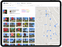
RoadBotics Introduces AgileMapper, a New Asset Mapping Platform
PITTSBURGH, PA – RoadBotics is excited to announce the release of their new AgileMapper platform to its suite of products that helps users digitize their infrastructure assets and manage projects efficiently. AgileMapper snaps, tags, and maps assets with the speed and power of artificial intelligence. “After almost a year in the making, AgileMapper has evolved into a powerful standalone platform and app to easily capture, view, and assess infrastructure data,” explains Matt Lucas, Head of Pr...
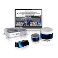
Velodyne Lidar Launches Breakthrough Intelligent Infrastructure Solution
Rutgers University Selects Velodyne’s Solution as Cornerstone Technology for New Jersey Department of Transportation Smart City Project SAN JOSE, Calif. – Velodyne Lidar, Inc. (Nasdaq: VLDR, VLDRW) today launched its Intelligent Infrastructure Solution designed to solve some of the most challenging and pervasive infrastructure problems. This new solution combines Velodyne’s award-winning lidar sensors and Bluecity’s powerful artificial intelligence (AI) software to monitor traffic networks a...

Now Available Belimo SelectPro™ Online
Danbury, CT – Belimo Americas is excited to announce SelectPro™, the sizing and selection tool is now integrated onto the Belimo website! The union of SelectPro and the website now enables you to choose products, add to a schedule, or place them directly into your cart! SelectPro is a quick and simple tool for accurately sizing and selecting actuators and valves. SelectPro has easy and intuitive navigation. Having the tool integrated into the website is a win-win – size, select, and purchase or...

GeoMax introduces new X-PAD 365 service platform
GeoMax connects its entire X-PAD software portfolio, offers integrated applications and services that are accessible anytime, anywhere (Widnau, Switzerland) – GeoMax Positioning, part of Hexagon, introduces the new X-PAD 365 web-based cloud platform that addresses data management and collaboration challenges surveyors and construction professionals meet every day. The web-based platform provides online file management, allowing users to access and store data in the cloud. Users of GeoMax X-PAD...
Test range for UAV-based geophysical sensors launched in Latvia
Riga, Latvia - SPH Engineering announces the official launch of its in-house drone flight area, enriched with a unique 450x70 meter range for various types of geophysical sensor testing with UAVs. The purpose-built testing ground features multiple targets of different materials and sizes buried in a variety of soil types. SPH Engineering’s test range is designed for manufacturers, surveying and scientific teams for equipment testing and various experiments. The four distinct seasons in Latvia...
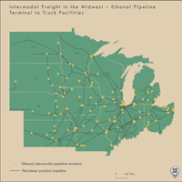
BTS Releases Spring 2021 Updates to National Transportation Atlas Database (NTAD)
U.S. Department of Transportation sent this bulletin at 04/29/2021 11:00 AM EDT National Transportation Atlas Database Spring 2021 Includes New Pipeline Dataset, 8 Other Updates The Spring 2021 update to the National Transportation Atlas Database (NTAD) was released today with the new pipeline intermodal freight facility layer and eight updated datasets. The pipeline addition brings to 89 the total number of geospatial datasets in the NTAD collection representing the nation’s transpor...
Bentley Systems Announces Acquisitions of sensemetrics and Vista Data Vision, Leaders Respectively in Software for Infrastructure Instrumentation and Sensor Management
To Accelerate the “Infrastructure IoT” Opportunity, for Living Digital Twins! EXTON, Pa. – Bentley Systems, Incorporated (Nasdaq: BSY), the infrastructure engineering software company, today announced its acquisitions of sensemetrics (agreement executed) and Vista Data Vision (closed), leading providers of software for Internet of Things (IoT) applications used extensively in infrastructure. sensemetrics and Vista Data Vision will expand the scope of the Bentley iTwin platform to add int...

Hexagon’s HxDR to host 3DNL, Cyclomedia’s Digital Twin of the Netherlands
Cyclomedia's 3DNL, a complete digital twin of the Netherlands, is collected with the Leica CityMapper-2 and hosted on HxDR. Hexagon provides Cyclomedia with Leica CityMapper-2 to capture nationwide 3D data and the HxDR cloud-based visualisation and collaboration platform for geospatial data and services (Heerbrugg, Switzerland, 29 April 2021) Hexagon’s Geosystems division, a global leader in sensor, software and autonomous solutions, announces that Dutch company Cyclomedia uses HxDR,...

5G Promises to Revolutionize Water Management on the Inevitable Road Towards Digital Transformation
5G to take off definitively in a large number of countries this year 29 April, 2021. 5G is set to transform the way mobile networks are designed and the way they are used, going way beyond simply improving the functionalities offered by 4G. Thanks to its low latency and its ability to connect millions of devices in a small area, among other advantages, it is set to bring numerous new business opportunities and value-added services. In 2020, 5G deployment accelerated across the gl...
Latest Topcon Construction and Survey Software Available Now for Compatible, Comprehensive Connectivity
LIVERMORE, Calif.- Topcon Positioning Group announces the newest release of its suite of software for construction and survey professionals. MAGNET 7 is designed to utilize the strength that cloud-based connectivity can play in streamlining workflows through GNSS receivers, total stations, and other positioning tools and instruments, and addresses common needs to increase productivity, efficiency, and profitability levels across the job site spectrum. The software is also designed to improve acc...
Stormwater Interview with Robert Page, P.E., Vice President, HNTB

TriMet’s Banfield Type 1 Substation Replacement Project

February Issue 2026
