
Parrot, Verizon, and Skyward bring first 4G LTE connected drone to the US market
New York, United States - Paris, France – August 4th, 2021: Today, Verizon, Parrot, and Skyward announced an exclusive partnership to bring the first out-of-the-box 4G LTE connected drone solution to the United States. Parrot ANAFI Ai is the first and only off-the-shelf drone to connect to Verizon’s 4G LTE network. Verizon 4G LTE connectivity is provided exclusively to Skyward subscribers at no additional cost. The Skyward Connected Drone Solution gives enterprises one complete experience fo...
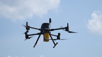
Wingtra launches WingtraOne GEN II—a next-generation VTOL drone with an oblique payload and advanced reliability algorithms
Zurich — After six years in development and 100'000 flights, Wingtra, the professional drone producer, is launching WingtraOne GEN II, a next-generation VTOL drone that offers industrial reliability and mapping versatility with a new oblique camera configuration for high-quality 3D drone mapping data capture. Known for its vertical take-off and landing (VTOL) precision and dependable data capture over large areas, WingtraOne has been chosen by professionals worldwide across many industries....

Digital Twin Consortium Unveils Maturity Model for Real Estate and Construction Industry
Whitepaper guides infrastructure stakeholders on digital twin adoption BOSTON, MA – Digital Twin Consortium® announced the Infrastructure Digital Twin Maturity: A Model for Measuring Progress whitepaper to guide infrastructure stakeholders as they incorporate digital twins in their projects. The paper outlines a five-stage process they can follow based on their organization's digital twin maturity level. "Real estate owners recognize the importance of digital transformation of their processe...

Podcast: Bentley Transportation Software for Small Business
Traditionally, many have viewed Bentley software as a solution for large organizations and megaprojects. Until now many small businesses believed that their projects were too small for the same technology and that the cost was unsustainable for their business model. Bentley’s transportation software was developed by engineers to improve road projects both small and large and Virtuosity, a Bentley Company, has now made it accessible and affordable for small businesses. Whether you are loo...

DuPont Selected to Provide Membrane Technology to Sorek B, Israel’s Largest Desalination Plant
IDE Water Technologies Selects FilmTec™ Membranes for Groundbreaking Desalination Plant WILMINGTON, Del., July 27, 2021, – DuPont (NYSE:DD) today announced that its FilmTec™ membranes have been selected by IDE Water Technologies to provide the sea water reverse osmosis (SWRO) filtration for the Sorek B desalination plant in Israel. The 25-year, 200 million m3/year facility, which will be the largest desalination plant in Israel and one of the largest in the world, is predicted to set...

Cupix Announces Integration with Autodesk BIM 360 Platform, Delivering Full 360-Degree Spatial Context for Construction Sites
Cupix Expands BIM/VDC Leadership by Integrating with Autodesk, Autodesk’s PlanGrid and Hires Industry Veteran as Head of BIM/VDC Strategy Cupix, the fast-growth pioneer of cutting-edge 3D digital twin solutions for the architecture, engineering and construction (AEC) industries and building owners, today announced integration of its CupixWorks 2.0 3D digital twin platform with Autodesk’s industry-leading BIM 360 construction management platform. Cupix’s new cross-platform integration with...
SPH Engineering announces the update of UgCS for UAV-based LIDAR mapping
Riga, Latvia - SPH Engineering announces the release of UgCS update, introducing LIDAR toolset to unlock the full potential of LIDARs making remote sensing most effective with no human errors. Key features include precise calibration, flight patterns for route planning, anti-shake turns, and constant line spacing and buffer. UgCS LIDAR toolset allows to optimize time and cost-effectiveness at all stages of data collection and processing. At the flight planning stage time could be saved on mi...

PERI Formwork Systems, Inc., Upgrades QuickSolve, Empowers Contractors with Even More Powerful Online Planning Tool
Enhanced Web-Based Platform Streamlines Data Capture, Provides Greater Functionality ELKRIDGE, MD (July 20, 2021) – PERI Formwork Systems, Inc., one of the leading manufacturers and suppliers of formwork and scaffolding systems for today’s construction environment, has released an enhanced edition of PERI QuickSolve, a free web-based planning tool that empowers contractors and estimators to sketch out a project and identify the best wall formwork solutions based on the specific characteristic...

HDR Expands Capabilities of its Proprietary Zero Emissions Fleet Optimization and Feasibility Modeling Tool
OMAHA, Neb. — HDR has upgraded its proprietary Zero+ Fleet Optimization and Feasibility Modeling Tool to evaluate all manner of fleets more precisely. The upgraded tool will better serve fleet owners making zero emissions transitions, with detailed analysis of power consumption and vehicle capabilities. Working with international research and development consultant Mitacs and the globally recognized University of Toronto, HDR integrated greenhouse gas emissions as an output capability and add...
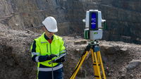
Maptek consolidates on field benefits for high accuracy survey-grade sensors
A new dual-window scanner that halves data capture time headlines the latest Maptek mine measurement improvements. The exciting new Maptek XR3-D mkII laser scanner with dual window arrangement cuts scan acquisition time in half. Conventional terrestrial laser scanners capture data from one window, spinning to achieve a 360° field of view; the XR3-D captures data from both sides simultaneously, with the scanner head only needing to spin 180°. ‘Survey crews can incidentally scan surrounding...
Stormwater Interview with Robert Page, P.E., Vice President, HNTB

TriMet’s Banfield Type 1 Substation Replacement Project

February Issue 2026
