Trimble Introduces Industry’s First Horizontal Steering Control for Soil Compactors
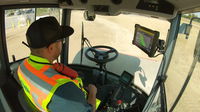
SUNNYVALE, Calif. —Trimble (NASDAQ: TRMB) announced today Horizontal Steering Control functionality on the Trimble® Earthworks Grade Control Platform for Soil Compactors, the industry’s first automatic steering control solution for soil compactors—and the next step towards Trimble’s autonomous vision. Horizontal Steering Control helps operators achieve higher quality surfaces and consistent compaction. Compatibility with all soil compactor makes and models enables contractors with mixed fleets t...

The Six Water Technology Trends for 2022, According to Idrica
These trends are set to bring innovative use cases to transform the industry and ensure the sustainable management of water and its availability. Climate change and water scarcity are challenges that must be tackled urgently. The future depends on digital transformation as a way to extract value from data and turn information into business intelligence. AMI infrastructure, digital twins, intelligent asset management, Geographical Information Systems, 5G and Artificial Intelligence are the...

MDOT Using LiDAR Technology for Road Construction
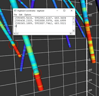
JACKSON, MISS. – The Mississippi Department of Transportation (MDOT) is using LiDAR (light detection and ranging), to improve efficiency and safety in the construction and maintenance of road projects around the state. LiDAR is a method for determining ranges or distances by targeting an object with a laser and measuring the time for the reflected light to return to the receiver. The reflected light data is then converted into distance measurements creating a 3-D model of what was measured....
Golden Software Facilitates Map Making and Data Export in Latest Surfer® Surface Mapping Package
Get more information from 3D models in Surfer by digitizing XYZ coordinates of spot locations. GOLDEN, Colorado – Golden Software, a developer of affordable 2D and 3D scientific modeling packages, has enhanced the map-making functionality and data exporting capabilities in the latest version of its Surfer surface mapping package. “In this version, we focused on making it easier and faster for Surfer users to create the maps they envision without time-consuming workarounds or using oth...

U.S. Federal Highway Administration Approves one.network’s Work Zone Data Exchange Feed for DOT Use, Company Offers It Free of Charge
After extensive compliance testing, one.network’s feed becomes the most comprehensive national solution to deliver work zone data to agencies, third parties, GPS navigational applications, and connected and autonomous vehicles. WILMINGTON, Delaware – one.network, a leading software innovator delivering platform-based, real-time traffic management and event information, announced today that the U.S. Federal Highway Administration (FHWA) has approved the company’s Work Zone Data Exchange (...

International Public Works Professionals Select Top Five Trending Technologies for 2022
Kansas City, MO – After tallying over 1,000 votes from public works professionals internationally, the American Public Works Association (APWA) has announced its Top Five Trending Technologies for 2022. APWA’s Top Trending Technologies highlights trending technologies with practical applications designed to aid public works professionals delivering essential services to communities of all sizes, and to meet the needs of various populations. A technology is considered trending due to its proj...
Propex Launches New Engineered Mattress System for Scour and Erosion Protection
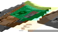
Propex is starting 2022 with the launch of PYRAMATTRESS® Engineered Mattress System, an erosion control solution designed to resist potential scour and erosion caused by the constant flow of water or high hydraulic stresses. The system utilizes the durability and erosion resistance of PYRAMAT® 75 High-Performance Turf Reinforcement Mat (HPTRM) to construct a geosynthetic, soil, and rock composite for protection of channels, slopes, and spillways. The design of this system allows for small...
GSSI Highlights Innovative PaveScan® RDM 2.0 Asphalt Density Assessment Tool at 2022 Transportation Research Board Meeting
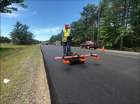
GSSI, the world’s leading manufacturer of ground penetrating radar (GPR) equipment, announces that it will feature its industry-leading PaveScan® RDM 2.0 asphalt density assessment tool at the Transportation Research Board’s (TRB) 101st Annual Meeting, which takes place January 9-13, 2022 at the Walter E. Washington Convention Center in Washington, D.C. Drop by Booth #831 to see a demonstration of PaveScan RDM 2.0, which uses the dielectric measurements of new pavement to determine pavement qual...

Nemetschek Group Announces Strategic Investment in Norwegian Start-Up Imerso
Combining reality capture and AI to close the gap between BIM and on-site fieldwork Imerso’s smart construction monitoring platform enables true-to-life digital twins In line with Nemetschek strategy of investing in AEC/O innovators Munich / Oslo – The Nemetschek Group, one of the leading software providers for the architecture, engineering, construction, and operations (AEC/O) industry, has led a financing round for Imerso AS. The Norway based deep-tech company is offering a next-gen...

Evolution of Narrow Band IoT in Remote Water Consumption Readings
Carlos Tejedor (Idrica): we must get ready. In the short term, everything will have sensors in the water industry. The NB standard will coexist with 5G to support billions of sensors. The Spanish city of Gandia was the first municipality to have tens of thousands of meters working with NB technology, in a project led by Idrica, Vodafone and the Gandia city council. This was the first Smart Water City with Narrow Band (NB) applied to remote metering. The project led the city to become...
Stormwater Interview with Robert Page, P.E., Vice President, HNTB

TriMet’s Banfield Type 1 Substation Replacement Project

February Issue 2026
