
FARO Releases Focus Core Laser Scanner
Lake Mary, Fla – FARO® Technologies, Inc. (Nasdaq: FARO), a global leader in 4D digital reality solutions, today announced the release of the FARO® Focus Core Laser Scanner. The new Focus Core broadens the Focus family’s potential range of applications by providing the ideal combination of price and performance on the market. Fully integrated into FARO’s workflow solutions for application-specific insights, Focus Core uniquely serves the company’s key markets in construction, building operations...
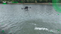
TOPODRONE advances airborne bathymetric surveying with AQUAMAPPER launch at INTERGEO 2022
Montreux, Switzerland – TOPODRONE, a Swiss based designer and manufacturer of high-precision LiDAR equipment for installation on drones, vehicles and backpacks, launches AQUAMAPPER, a UAV-based solution for bathymetric surveying and marine construction. The new multitasking data collecting device and TOPODRONE LiDAR ULTRA equipment have been successfully used together for airborne surveying at a highway construction project in Romania, EU to deliver a full digital twin of a studied area. AQU...
UP42 Launches ArcGIS Pro Add-in as Part of Esri Partner Network
ArcGIS users have direct access to the UP42 platform for easier data visualization and analysis BERLIN, Germany – UP42 made the first major announcement of its new partnership with the introduction of the UP42 ArcGIS Pro Add-in. Available on the Esri ArcGIS Marketplace, the UP42 add-in allows users to access UP42 data sets and projects from within ArcGIS Pro. UP42, a Silver Partner in the Esri Partner Network (EPN), unveiled the add-in today in stand C1.020 at the INTERGEO 2022 Conference...

Emesent launches three time saving products for geospatial professionals
Hovermap ST-X, the newest edition of Emesent’s award-winning Hovermap autonomy and mapping device, captures detailed, accurate data over a greater area in less time. Hovermap ST-X, Long Range Radio, and Emesent’s Aura software platform were launched at INTERGEO, providing a versatile combination to scan large areas and complex assets in less time and visualize the results in full detail. Emesent, World leader in drone autonomy, LiDAR mapping, and data analytics today launched thr...
Teledyne announces new Ladybug6 cameras for high accuracy 360-degree spherical image capture
Richmond, CANADA ─ Teledyne FLIR Integrated Imaging Solutions is pleased to announce the all new Ladybug6— the latest addition to its field proven Ladybug series. Ladybug6 is the leading high-resolution camera designed to capture 360-degree spherical images from moving platforms in all-weather conditions. Its industrial grade design and out-of-the-box factory calibration produces 72 Megapixel (MP) images with pixel values that are spatially accurate within +/- 2 mm at 10-meter distance. “The...

Vectorworks, Inc. Offers New Industry-Specific Professional Certification Courses
Online Training Courses Offer an Innovative way to Advance Designers’ Careers. Columbia, MD — Global design and BIM software provider Vectorworks, Inc. invites designers to take the next step in their careers with the new professional certification course program for Vectorworks Architect, Landmark and Spotlight. The comprehensive courses are available to all users across the globe and cover the essential tools, commands and concepts needed to increase proficiency in Vectorworks' indust...

Allplan 2023: The Multi-Material Solution for Ultimate Buildability
New version allows interdisciplinary AEC teamwork on a single platform. Copyright: ALLPLAN New version allows interdisciplinary AEC teamwork on a single platform / Coordination of materials and construction methods / Superior BIM workflows and real-time collaboration Munich - ALLPLAN, provider of BIM solutions for the AEC industry, launches the new version of its BIM software Allplan 2023. As a connecting platform for interdisciplinary collaboration between architects, engineers, prec...

Epson Advances Immersive Workforce Collaboration with New Generation of Moverio AR Smart Glasses
Moverio BT-45C and BT-45CS Offer Advanced Imaging Technology and Wider Field-of-View to Foster Seamless Collaboration for Evolving Business Needs LOS ALAMITOS, Calif. – Meeting the rapidly growing demand for remote assistance technology, Epson today announced the Moverio® BT-45C and BT-45CS, a new generation of award-winning Moverio augmented reality (AR) smart glasses designed to support seamless remote collaboration with a high-quality AR viewing experience. Purpose-built for mission-c...
New era of property risk management enabled by transformational location intelligence technology
Nearmap automated fire risk assessments (prototype) Nearmap announces product roadmap built on market-leading artificial intelligence platform: automated roof condition assessment, fire risk assessment, flood risk assessment, and artificial intelligence insights for natural disasters Fifth generation of Nearmap AI also launched at annual customer event, Nearmap NAVIG8 2022 Salt Lake City, Utah — Organizations responding to the challenges of a changing climate – in sectors i...
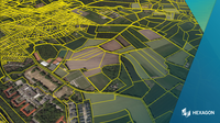
Build geospatial apps faster with Hexagon’s M.App Enterprise 2023
HUNTSVILLE, Ala. – Hexagon’s Safety, Infrastructure & Geospatial division has released M.App Enterprise 2023, a significant update to its platform for creating geospatial and location intelligence applications. The latest release enables users to create applications faster and delivers a seamless layout across desktop, browser and mobile components. M.App Enterprise 2023 features a completely updated design for an enhanced user experience. Users can create applications with fewer clicks, and...
Stormwater Interview with Robert Page, P.E., Vice President, HNTB

TriMet’s Banfield Type 1 Substation Replacement Project

February Issue 2026
