
Bridge protection and traffic safety at its finest
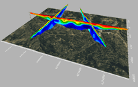
The Great Belt Bridge in Denmark, one of the world’s longest suspension bridges, benefits from Structural Health Monitoring thanks to measurement technology by Kistler Kistler presents unique Structural Health Monitoring and Weigh In Motion portfolio at Intertraffic 2024 Winterthur, February 2024 The next stop for condition monitoring of sensitive infrastructure: the Kistler Group is showcasing its latest solution for bridge protection and traffic safety, a comprehensive Structural Health...

Trimble Introduces Roadworks Paving Control Platform for Mills and Cold Planers
New version of Trimble’s next-generation paving control platform for smoother, more precise paving surfaces extends the functionality to an additional machine type WESTMINSTER, Colo., February 20, 2024 — Trimble (NASDAQ: TRMB) announced today the availability of the Trimble® Roadworks Paving Control Platform for Mills and Cold Planers, extending the functionality of Trimble’s next-generation, 3D paving control system. Trimble Roadworks for Mills and Cold Planers runs on an Android™ opera...

LEC’s New Cutting-Edge Website
LEC is Integrating Industrial Engineering and Design with Smart Water for an Unparalleled User Experience with the Introduction of its New Website. Pearl, MS – 2/20/2024 – LEC, a trailblazer in smart water and wastewater management solutions, and a well-established industrial engineering firm proudly announces the launch of its new website, a significant milestone in the company’s commitment to innovation and technological advancement. As the world grapples with escalating resource challenge...

Siemens presents innovative and sustainable building technology at MCE 2024
- Siemens provides sustainable heating, cooling and ventilation solutions and thus, supports partners and customers in the decarbonization of buildings - One of the highlights will include an energy efficient magnetic expansion valve, with which OEMs can gain up to 21% more heating capacity - Also being showcased is a heat pump automation system as part of Siemens Xcelerator At this year's Mostra Convegno Expocomfort (MCE) trade show, Siemens Smart Infrastructure will present a broad...

New ARTBA Website Is Hub for Infrastructure Law and Transportation Policy
ARTBA.org Built for Association Members, Congressional Staff and News Media WASHINGTON – The American Road & Transportation Builders Association (ARTBA) has launched a redesigned flagship website to showcase how its members are using 2021’s Infrastructure Investment and Jobs Act (IIJA) to improve and revitalize communities across America. With more than 50 written stories and a dozen videos of projects moving forward with help from the IIJA, artba.org also provides valuable informa...
Latest Surfer® Mapping and 3D Visualization Package from Golden Software Gives Users Comprehensive View of Subsurface Data
Import imagery, such as PNG files of geophysical profiles, and position the images in any orientation! Import any georeferenced images, such as an aerial image in GeoTIFF format, and it is placed directly in the correct location. GOLDEN, Colorado, 13 February 2024 – Golden Software has further enhanced the 3D visualization capabilities of its Surfer mapping and 3D visualization software to give users a complete picture of their subsurface data. The expanded visualization tools in the lat...
Trimble and DroneDeploy Introduce Premier Positioning Accuracy and Streamlined Workflow for Reality Capture from Drones
RTX-based cloud positioning service expands project opportunities for drone mapping DENVER – GEO WEEK (Booth# 1001) – Trimble (NASDAQ: TRMB) announced today the integration of the Trimble Applanix POSPac CloudⓇ post-processed kinematic (PPK) GNSS positioning service, featuring CenterPointⓇ RTX, with the drone mapping and data collection capabilities of DroneDeploy’s reality capture platform. With the Trimble cloud positioning service, DroneDeploy customers can expect centimeter-level acc...

DJI Launches Its First Intelligent 3D Model Editing Software DJI Modify
Makes repairing common 3D model defects simple and efficient January 18, 2024 – DJI, the world’s leader in civil drones and creative camera technology, today introduced DJI Modify, the company’s first intelligent 3D model editing software. This complementary solution pairs seamlessly with DJI’s enterprise drones and 3D modeling and mapping software, DJI Terra, forming a comprehensive solution for aerial surveying, modeling, and model editing, to meet the operational needs for surveying,...

Trimble Introduces MX90 Mobile Mapping System
Trimble announced today the leading-edge Trimble® MX90 mobile mapping system. With state-of-the-art Trimble GNSS and inertial technology, when combined with Trimble field and office software, the Trimble MX90 provides a complete field-to-finish mobile mapping solution that enables powerful workflows for data capture, processing and analysis. Richer Data for Large-Scale Scanning & Mobile Mapping Projects The vehicle- or train-mounted MX90 rapidly captures highly detailed laser scans an...

Exyn Unveils Nexys: A Fully Modular 3D Mapping Solution for Complex and Challenging Environments
GEOWEEK, FEBRUARY – Exyn Technologies, a pioneer in autonomous robotics, today announced the launch of Exyn Nexys, a revolutionary modular 3D mapping solution. Designed for professionals in mining, construction, AEC, and geospatial industries, Nexys sets a new standard in autonomous mapping technology, offering unparalleled flexibility, speed, and accuracy in the most demanding surveying and inspection environments. Unmatched Modularity for Every Mapping Scenario Nexys’ groundbreaking modu...
Stormwater Interview with Robert Page, P.E., Vice President, HNTB

TriMet’s Banfield Type 1 Substation Replacement Project

February Issue 2026
